
FCCInfo.com
A Service of Cavell, Mertz & Associates, Inc.
(855) FCC-INFO
|
|
KGSW-LD from 10/01/2012 KGSW-LD from 04/10/1998 KGSW-LD from 01/28/1997 KGSW-LD from 05/24/1995 |
|
|
||||||||||||||||
|
|
Status: License Application Accepted: 02/18/2020 License Expires: 08/01/2022 File Number: -0000106132 FCC Website Links: LMS Facility Details This Application Other KGSW-LD Applications Including Superseded Applications Mailing Address Correspondence for KGSW-LD Correspondence related to application -0000106132 Service Contour - Open Street Map or USGS Map (51 dBu) Service Contour - KML / Google Earth (51 dBu) Rabbit Ears Info Search for KGSW-LD Site Location: 32-24-20.5 N 97-19-55.3 W (NAD 83) Site Location: 32-24-20.0 N 97-19-54.2 W (Converted to NAD 27) ERP: 7 kW Polarization: Horizontally polarized Electrical Beam Tilt: 0.5 degrees R/C AGL: 85.9 m (282 ft.) R/C AMSL: 363 m (1191 ft.) Emission Mask: Stringent Site Elevation: 277.1 m. (909 ft.) Height Overall*: 106.7 m (350 ft.) (* As Filed In This Application, may differ from ASR Data, Below.) Directional Antenna - Antenna Make/Model: Scala 1469B Antenna ID: 1006425 Polarization: Horizontally polarized | ||||||||||||||||||
| Antenna Data for Antenna Id: 1006425 KGSW-LD LD File: -0000106132 Scala - 1469B Service: LD Standard Pattern: N Pattern and Field Values Include a 347° Clockwise Rotation | 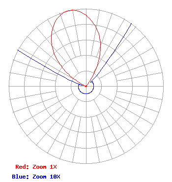 | ||||||||||||||||||
| Azimuth | Ratio | Azimuth | Ratio | Azimuth | Ratio | Azimuth | Ratio | ||||||||||||
| 7 | 0.812 | 17 | 0.622 | 27 | 0.361 | 37 | 0.086 | ||||||||||||
| 47 | 0.015 | 57 | 0.010 | 67 | 0.010 | 77 | 0.010 | ||||||||||||
| 87 | 0.010 | 97 | 0.010 | 107 | 0.010 | 117 | 0.010 | ||||||||||||
| 127 | 0.010 | 137 | 0.010 | 147 | 0.010 | 157 | 0.010 | ||||||||||||
| 167 | 0.010 | 177 | 0.010 | 187 | 0.010 | 197 | 0.010 | ||||||||||||
| 207 | 0.010 | 217 | 0.010 | 227 | 0.010 | 237 | 0.010 | ||||||||||||
| 247 | 0.010 | 257 | 0.010 | 267 | 0.010 | 277 | 0.010 | ||||||||||||
| 287 | 0.010 | 297 | 0.086 | 307 | 0.361 | 317 | 0.622 | ||||||||||||
| 327 | 0.812 | 337 | 0.947 | 347 | 1.000 | 357 | 0.947 | ||||||||||||
Structure Registration Number 1297515 Structure Type: GTOWER Registered To: Southwestern Adventist University Structure Address: 425 Linden St Keene, TX County Name: Johnson County ASR Issued: 02/15/2018 Date Built: 11/24/2016 Site Elevation: 277.1 m (909 ft.) Structure Height: 105.8 m (347 ft.) Height Overall: 106.7 m (350 ft.) Overall Height AMSL: 383.8 m (1259 ft.) FAA Determination: 07/01/2015 FAA Study #: 2015-ASW-1424-OE FAA Circular #: 70/7460-1K Paint & Light FAA Chapters: 3, 4, 5, 12 Removed expiration date from determination. Scenario 1./jjs/case#635066 32-24-20.5 N 97-19-55.3 W (NAD 83) 32-24-20.0 N 97-19-54.2 W (Converted to NAD 27) |
Southwestern Adventist University Keene, TX 76059 Phone: 817-202-6333 Not-for-Profit | Title: President Date: 02/18/2020 Application Certifier SOUTHWESTERN ADVENTIST UNIVERSITY Southwestern Adventist University Southwestern Adventist University Keene, TX 76059 Applicant DONALD MARTIN Donald E. Martin, P.c. Falls Church, VA 22041 ATTORNEY Douglas L Vernier Doug Vernier, Telecommunications Consultants, Llc Doug Vernier Telecommunications Consultants 1600 Picturesque Dr. Cedar Falls, IA 50613 Broadcast Engineering Consultant | |||||||||||||||||