
FCCInfo.com
A Service of Cavell, Mertz & Associates, Inc.
(855) FCC-INFO
|
|
WOOT-LD from 01/02/2013 WOOT-LD from 12/05/2012 WOOT-LD from 02/22/2000 WOOT-LD from 04/29/1988 WOOT-LD from 02/04/1985 |
|
|
|||||||||||||||||||||||||||||||||||
|
|
Status: License Application Accepted: 03/23/2020 License Expires: 08/02/2021 File Number: -0000108610 FCC Website Links: LMS Facility Details This Application Other WOOT-LD Applications Including Superseded Applications Mailing Address Correspondence for WOOT-LD Correspondence related to application -0000108610 Service Contour - Open Street Map or USGS Map (51 dBu) Service Contour - KML / Google Earth (51 dBu) Rabbit Ears Info Search for WOOT-LD Site Location: 35-12-26.0 N 85-16-52.0 W (NAD 83) Site Location: 35-12-25.7 N 85-16-52.1 W (Converted to NAD 27) ERP: 15 kW Polarization: Horizontally polarized Electrical Beam Tilt: 1.0 degree R/C AGL: 71.7 m (235 ft.) R/C AMSL: 685 m (2247 ft.) Emission Mask: Full Service Site Elevation: 613.3 m. (2012 ft.) Height Overall*: 150.3 m (493 ft.) (* As Filed In This Application, may differ from ASR Data, Below.) Directional Antenna - Antenna Make/Model: PS PSILP12OI Antenna ID: 1006580 Polarization: Horizontally polarized
| |||||||||||||||||||||||||||||||||||||
| Antenna Data for Antenna Id: 1006580 WOOT-LD LD File: -0000108610 PS - PSILP12OI Service: LD Standard Pattern: N Pattern and Field Values Include a 175° Clockwise Rotation | 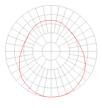 | |||||||||||||||||||||||||||||||||||||
| Azimuth | Ratio | Azimuth | Ratio | Azimuth | Ratio | Azimuth | Ratio | |||||||||||||||||||||||||||||||
| 5 | 0.670 | 15 | 0.660 | 25 | 0.640 | 35 | 0.620 | |||||||||||||||||||||||||||||||
| 45 | 0.600 | 55 | 0.600 | 65 | 0.610 | 75 | 0.630 | |||||||||||||||||||||||||||||||
| 85 | 0.660 | 95 | 0.710 | 105 | 0.760 | 115 | 0.820 | |||||||||||||||||||||||||||||||
| 125 | 0.870 | 135 | 0.910 | 145 | 0.950 | 155 | 0.980 | |||||||||||||||||||||||||||||||
| 165 | 1.000 | 175 | 1.000 | 185 | 1.000 | 195 | 0.980 | |||||||||||||||||||||||||||||||
| 205 | 0.950 | 215 | 0.910 | 225 | 0.870 | 235 | 0.820 | |||||||||||||||||||||||||||||||
| 245 | 0.760 | 255 | 0.710 | 265 | 0.660 | 275 | 0.630 | |||||||||||||||||||||||||||||||
| 285 | 0.610 | 295 | 0.600 | 305 | 0.600 | 315 | 0.620 | |||||||||||||||||||||||||||||||
| 325 | 0.640 | 335 | 0.660 | 345 | 0.670 | 355 | 0.670 | |||||||||||||||||||||||||||||||
Structure Registration Number 1042763 [ASR Heights Differ from WOOT-LD Application] Structure Type: GTOWER Registered To: GREATER CHATTANOOGA PUBLIC TELEVISION CORPORATION Structure Address: Sawyer Cemetery Rd Signal Mountain, TN County Name: Hamilton County ASR Issued: 06/09/2022 Date Built: 06/10/2022 Site Elevation: 613.3 m (2012 ft.) Structure Height: 135.6 m (445 ft.) Height Overall: 135.6 m (445 ft.) Overall Height AMSL: 748.9 m (2457 ft.) FAA Determination: 09/09/2014 FAA Study #: 2014-ASO-8387-OE FAA Circular #: 70/7460-1K Paint & Light FAA Chapters: 3, 4, 5, 12 PRIOR STUDY 1992-ASO-1871-OE 35-12-26.0 N 85-16-52.0 W (NAD 83) 35-12-25.7 N 85-16-52.1 W (Converted to NAD 27) |
Chattanooga, TN 37401 Phone: 202-293-0567 Limited Liability Company | Title: Coo Date: 03/23/2020 Application Certifier DIGITAL NETWORKS-SOUTHEAST, LLC Digital Networks-southeast, Llc Chattanooga, TN 37401 Applicant Jeremy D Ruck, PE Jeremy Ruck & Associates, Inc. Canton, IL 61520 Consulting Engineer Aaron P Shainis, Esq Shainis & Peltzman, Chartered 1850 M Street Nw Suite 240 Washington, DC 20036 Attorney | ||||||||||||||||||||||||||||||||||||
| ||||||||||||||||||||||||||||||||||||||