
FCCInfo.com
A Service of Cavell, Mertz & Associates, Inc.
(855) FCC-INFO
|
|
WSJZ-LD from 05/11/2017 WSJZ-LD from 05/29/2012 |
Virtual Channel 33 |
|
|||||||||||||||||||
|
|
Status: License Application Accepted: 03/31/2020 License Expires: 10/01/2020 File Number: -0000110689 FCC Website Links: LMS Facility Details This Application Other WSJZ-LD Applications Including Superseded Applications Mailing Address Correspondence for WSJZ-LD Correspondence related to application -0000110689 Service Contour - Open Street Map or USGS Map (51 dBu) Service Contour - KML / Google Earth (51 dBu) Rabbit Ears Info Search for WSJZ-LD Site Location: 38-38-35.8 N 75-12-57.4 W (NAD 83) Site Location: 38-38-35.4 N 75-12-58.7 W (Converted to NAD 27) ERP: 9 kW Polarization: Horizontally polarized Electrical Beam Tilt: 1.5 degrees R/C AGL: 118.3 m (388 ft.) R/C AMSL: 125 m (410 ft.) Emission Mask: Full Service Site Elevation: 6.7 m. (22 ft.) Height Overall*: 122.5 m (402 ft.) (* As Filed In This Application, may differ from ASR Data, Below.) Directional Antenna - Antenna Make/Model: DIELECTRIC DLP-8B Antenna ID: 1006622 Polarization: Horizontally polarized
| |||||||||||||||||||||
| Antenna Data for Antenna Id: 1006622 WSJZ-LD LD File: -0000110689 DIELECTRIC - DLP-8B Service: LD Standard Pattern: N Pattern and Field Values Include a 270° Clockwise Rotation | 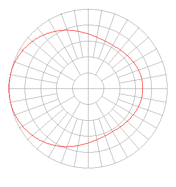 | |||||||||||||||||||||
| Azimuth | Ratio | Azimuth | Ratio | Azimuth | Ratio | Azimuth | Ratio | |||||||||||||||
| 0 | 0.686 | 10 | 0.653 | 20 | 0.633 | 30 | 0.627 | |||||||||||||||
| 40 | 0.632 | 50 | 0.646 | 60 | 0.662 | 70 | 0.678 | |||||||||||||||
| 80 | 0.689 | 90 | 0.692 | 100 | 0.689 | 110 | 0.678 | |||||||||||||||
| 120 | 0.662 | 130 | 0.646 | 140 | 0.632 | 150 | 0.627 | |||||||||||||||
| 160 | 0.633 | 170 | 0.653 | 180 | 0.686 | 190 | 0.729 | |||||||||||||||
| 200 | 0.778 | 210 | 0.828 | 220 | 0.875 | 230 | 0.918 | |||||||||||||||
| 240 | 0.953 | 250 | 0.979 | 260 | 0.995 | 270 | 1.000 | |||||||||||||||
| 280 | 0.995 | 290 | 0.979 | 300 | 0.953 | 310 | 0.918 | |||||||||||||||
| 320 | 0.875 | 330 | 0.828 | 340 | 0.778 | 350 | 0.729 | |||||||||||||||
Structure Registration Number 1033245 Structure Type: GTOWER Registered To: American Towers LLC Structure Address: Rt 307 @ Rt 5 ( 000023 ) Millsboro, DE County Name: Sussex County ASR Issued: 01/28/2013 Date Built: 04/14/2008 Site Elevation: 6.7 m (22 ft.) Structure Height: 122.2 m (401 ft.) Height Overall: 122.5 m (402 ft.) Overall Height AMSL: 129.2 m (424 ft.) FAA Determination: 10/16/2012 FAA Study #: 2012-AEA-5048-OE FAA Circular #: 70/7460-1K Paint & Light FAA Chapters: 4, 8, 12 PRIOR STUDY 2008-AEA-1499-OE 38-38-35.8 N 75-12-57.4 W (NAD 83) 38-38-35.4 N 75-12-58.7 W (Converted to NAD 27) |
1729 North Salisbury Boulevard Salisbury, MD 21801 Phone: 443-880-9090 Corporation | Title: President, Draper Media Date: 03/31/2020 Application Certifier WBOC, INC. Wboc, Inc. 1729 North Salisbury Boulevard Salisbury, MD 21801 Applicant Christina Burrow Cooley Llp 1299 Pennsylvania Avenue, Nw Suite 700 Washington, DC 20004 Joseph M. Davis, P.E. Chesapeake Rf Consultants, Llc 207 Old Dominion Road Yorktown, VA 23692 Consulting Engineer | ||||||||||||||||||||