
FCCInfo.com
A Service of Cavell, Mertz & Associates, Inc.
(855) FCC-INFO
|
|
|
Virtual Channel 3 |
|
||||||||||||||||
|
|
Status: License Application Accepted: 04/06/2020 License Expires: 10/01/2021 File Number: -0000111556 FCC Website Links: LMS Facility Details This Application Other WHNE-LD Applications Including Superseded Applications Mailing Address Correspondence for WHNE-LD Correspondence related to application -0000111556 Service Contour - Open Street Map or USGS Map (43 dBu) Service Contour - KML / Google Earth (43 dBu) Rabbit Ears Info Search for WHNE-LD Site Location: 42-26-52.5 N 83-10-23.1 W (NAD 83) Site Location: 42-26-52.4 N 83-10-23.4 W (Converted to NAD 27) ERP: 3 kW Polarization: Elliptically polarized Electrical Beam Tilt: 1.0 degree R/C AGL: 145 m (476 ft.) R/C AMSL: 346.8 m (1138 ft.) Emission Mask: Stringent Site Elevation: 201.8 m. (662 ft.) Height Overall*: 331.3 m (1087 ft.) (* As Filed In This Application, may differ from ASR Data, Below.) Directional Antenna - Antenna Make/Model: Propagation System Inc PSIVLDP3EC-3-EP Antenna ID: 1006640 Polarization: Elliptically polarized | ||||||||||||||||||
| Antenna Data for Antenna Id: 1006640 WHNE-LD LD File: -0000111556 Propagation System Inc - PSIVLDP3EC-3-EP Service: LD Standard Pattern: N Pattern and Field Values Include a 315° Clockwise Rotation | 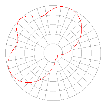 | ||||||||||||||||||
| Azimuth | Ratio | Azimuth | Ratio | Azimuth | Ratio | Azimuth | Ratio | ||||||||||||
| 5 | 0.963 | 15 | 1.000 | 25 | 0.985 | 35 | 0.931 | ||||||||||||
| 45 | 0.843 | 55 | 0.726 | 65 | 0.592 | 75 | 0.457 | ||||||||||||
| 85 | 0.340 | 95 | 0.244 | 105 | 0.157 | 115 | 0.109 | ||||||||||||
| 125 | 0.114 | 135 | 0.127 | 145 | 0.133 | 155 | 0.139 | ||||||||||||
| 165 | 0.177 | 175 | 0.253 | 185 | 0.345 | 195 | 0.471 | ||||||||||||
| 205 | 0.611 | 215 | 0.750 | 225 | 0.866 | 235 | 0.947 | ||||||||||||
| 245 | 0.985 | 255 | 0.977 | 265 | 0.920 | 275 | 0.834 | ||||||||||||
| 285 | 0.777 | 295 | 0.819 | 305 | 0.930 | 315 | 0.990 | ||||||||||||
| 325 | 0.945 | 335 | 0.833 | 345 | 0.804 | 355 | 0.879 | ||||||||||||
Structure Registration Number 1003429 Structure Type: GTOWER Registered To: American Towers LLC Structure Address: 20931 Meyers Rd (282678 / Detroit - Oak Park T1 Mi) Oak Park, MI County Name: Oakland County ASR Issued: 10/14/2016 Date Built: 06/11/1999 Site Elevation: 201.8 m (662 ft.) Structure Height: 308.5 m (1012 ft.) Height Overall: 331.3 m (1087 ft.) Overall Height AMSL: 533.1 m (1749 ft.) FAA Determination: 07/07/2016 FAA Study #: 2016-AGL-8945-OE FAA Circular #: 70/7460-1L Paint & Light FAA Chapters: 4, 9, 12 PRIOR STUDY 2014-AGL-12680-OE 42-26-52.5 N 83-10-23.1 W (NAD 83) 42-26-52.4 N 83-10-23.4 W (Converted to NAD 27) |
38955 Hills Tech Dr. Farmington Hills, MI 48331 Phone: 248-536-0776 Limited Liability Company | Title: Member Date: 04/06/2020 Application Certifier TAIT BROADCASTING, LLC Tait Broadcasting, Llc 27251 State Road 54 Suite B14-124 Wesley Chapel, FL 33544 Applicant GREGORY L BEST Greg Best Consulting 16100 Outlook Ave Stilwell, KS 66085 CONSULTING ENGINEER JAMES V LEBRATO Tait Broadcasting, Llc 24251 State Road 54 Suite B14-124 Wesley Chapel, FL 33544 MEMBER | |||||||||||||||||