
FCCInfo.com
A Service of Cavell, Mertz & Associates, Inc.
(855) FCC-INFO
|
|
|
Virtual Channel 42 |  |
|
|||||||||||||||||||||||||||
|
|
Status: License Application Accepted: 04/20/2020 License Expires: 12/01/2020 File Number: -0000112407 FCC Website Links: LMS Facility Details This Application Other WTVI Applications Including Superseded Applications Mailing Address Correspondence for WTVI Correspondence related to application -0000112407 Service Contour - Open Street Map or USGS Map (51 dBu) Service Contour - KML / Google Earth (51 dBu) History Cards for WTVI Rabbit Ears Info Search for WTVI Site Location: 35-39-27.4 N 81-24-24.3 W (NAD 83) Site Location: 35-39-26.9 N 81-24-25.0 W (Converted to NAD 27) ERP: 5 kW Polarization: Horizontally polarized R/C AGL: 48 m (157 ft.) R/C AMSL: 579 m (1900 ft.) Emission Mask: Full Service Site Elevation: 531 m. (1742 ft.) Height Overall*: 54.8 m (180 ft.) (* As Filed In This Application, may differ from ASR Data, Below.) Directional Antenna - Antenna Make/Model: Electronics Research Inc. ETU1U1-HSP2P-28 Antenna ID: 1006693 Polarization: Horizontally polarized | ||||||||||||||||||||||||||||||
| Antenna Data for Antenna Id: 1006693 WTVI LD File: -0000112407 Electronics Research Inc. - ETU1U1-HSP2P-28 Service: LD Standard Pattern: N Pattern and Field Values Include a 145° Clockwise Rotation | 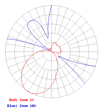 | ||||||||||||||||||||||||||||||
| Azimuth | Ratio | Azimuth | Ratio | Azimuth | Ratio | Azimuth | Ratio | ||||||||||||||||||||||||
| 5 | 0.130 | 15 | 0.190 | 25 | 0.210 | 35 | 0.180 | ||||||||||||||||||||||||
| 45 | 0.180 | 55 | 0.200 | 65 | 0.200 | 75 | 0.200 | ||||||||||||||||||||||||
| 85 | 0.210 | 95 | 0.200 | 105 | 0.130 | 115 | 0.050 | ||||||||||||||||||||||||
| 125 | 0.020 | 135 | 0.110 | 145 | 0.200 | 155 | 0.320 | ||||||||||||||||||||||||
| 165 | 0.460 | 175 | 0.640 | 185 | 0.810 | 195 | 0.930 | ||||||||||||||||||||||||
| 205 | 0.990 | 209 | 1.000 | 215 | 0.990 | 225 | 0.910 | ||||||||||||||||||||||||
| 235 | 0.780 | 245 | 0.630 | 255 | 0.480 | 265 | 0.330 | ||||||||||||||||||||||||
| 275 | 0.210 | 285 | 0.110 | 295 | 0.020 | 305 | 0.010 | ||||||||||||||||||||||||
| 315 | 0.070 | 325 | 0.080 | 335 | 0.070 | 345 | 0.030 | ||||||||||||||||||||||||
| 355 | 0.070 | ||||||||||||||||||||||||||||||
Structure Registration Number 1270703 Structure Type: Registered To: North Carolina State Highway Patrol Structure Address: Hp-1012, Baker Mt., 6680 Baker Mt. Road Hickory, NC County Name: Catawba County ASR Issued: 07/10/2015 Date Built: 09/30/2009 Site Elevation: 531 m (1742 ft.) Structure Height: 54.8 m (180 ft.) Height Overall: 54.8 m (180 ft.) Overall Height AMSL: 585.8 m (1922 ft.) FAA Determination: 01/08/2009 FAA Study #: 2008-ASO-6698-OE Paint & Light FAA Chapters: NONE 35-39-27.4 N 81-24-24.3 W (NAD 83) 35-39-26.9 N 81-24-25.0 W (Converted to NAD 27) |
3242 Commonwealth Ave. Charlotte, NC 28205 Phone: 704-330-5940 Government Entity | Title: General Manager Date: 04/20/2020 Application Certifier CENTRAL PIEDMONT COMMUNITY COLLEGE Central Piedmont Community College Po Box 35009 Charlotte, NC 28235 Applicant Gregory Best, P.E. Greg Best Consulting, Inc. 16100 Outlook Avenue Stillwell, KS 66085 Technical Representative LAWRENCE M. MILLER Garvey Schubert Barer 1000 Potomac Street, Nw Suite 200 Washington, DC 20007 Attorney | |||||||||||||||||||||||||||||
|
| ||||||||||||||||||||||||||||||