
FCCInfo.com
A Service of Cavell, Mertz & Associates, Inc.
(855) FCC-INFO
|
|
K33PV-D from 01/10/2011 |
|
|
||||||||||||||||
|
|
Status: License Application Accepted: 05/19/2020 License Expires: 02/01/2022 File Number: -0000113997 FCC Website Links: LMS Facility Details This Application Other K33PV-D Applications Including Superseded Applications Mailing Address Correspondence for K33PV-D Correspondence related to application -0000113997 Service Contour - Open Street Map or USGS Map (51 dBu) Service Contour - KML / Google Earth (51 dBu) Rabbit Ears Info Search for K33PV-D Site Location: 43-22-35.7 N 96-11-48.6 W (NAD 83) Site Location: 43-22-35.8 N 96-11-47.5 W (Converted to NAD 27) ERP: 15 kW Polarization: Horizontally polarized Electrical Beam Tilt: 0.5 degrees R/C AGL: 140.3 m (460 ft.) R/C AMSL: 570.1 m (1870 ft.) Emission Mask: Full Service Site Elevation: 429.8 m. (1410 ft.) Height Overall*: 147.3 m (483 ft.) (* As Filed In This Application, may differ from ASR Data, Below.) Directional Antenna - Antenna Make/Model: Andrew ALP16WR Antenna ID: 16648 Polarization: Horizontally polarized
| ||||||||||||||||||
| Antenna Data for Antenna Id: 16648 K33PV-D LD File: -0000113997 Andrew - ALP16WR Service: LD Standard Pattern: Y Pattern and Field Values Include a 147° Clockwise Rotation | 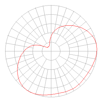 | ||||||||||||||||||
| Azimuth | Ratio | Azimuth | Ratio | Azimuth | Ratio | Azimuth | Ratio | ||||||||||||
| 7 | 0.412 | 17 | 0.521 | 27 | 0.612 | 37 | 0.697 | ||||||||||||
| 47 | 0.785 | 57 | 0.870 | 67 | 0.942 | 77 | 0.988 | ||||||||||||
| 87 | 1.000 | 97 | 0.986 | 107 | 0.961 | 117 | 0.940 | ||||||||||||
| 127 | 0.934 | 137 | 0.944 | 147 | 0.950 | 157 | 0.944 | ||||||||||||
| 167 | 0.934 | 177 | 0.940 | 187 | 0.961 | 197 | 0.986 | ||||||||||||
| 207 | 1.000 | 217 | 0.988 | 227 | 0.942 | 237 | 0.870 | ||||||||||||
| 247 | 0.785 | 257 | 0.697 | 267 | 0.612 | 277 | 0.521 | ||||||||||||
| 287 | 0.412 | 297 | 0.272 | 307 | 0.148 | 317 | 0.112 | ||||||||||||
| 327 | 0.111 | 337 | 0.112 | 347 | 0.148 | 357 | 0.272 | ||||||||||||
Structure Registration Number 1026022 Structure Type: GTOWER Registered To: IOWA PUBLIC BROADCASTING BOARD DBA IOWA PUBLIC TELEVISION Structure Address: 3.5 Mi Se Rock Rapids, IA County Name: Lyon County ASR Issued: 11/27/2019 Date Built: 05/09/2020 Site Elevation: 429.8 m (1410 ft.) Structure Height: 137.1 m (450 ft.) Height Overall: 147.3 m (483 ft.) Overall Height AMSL: 577.1 m (1893 ft.) FAA Determination: 02/12/2019 FAA Study #: 2018-ACE-8619-OE FAA Circular #: 70/7460-1L Paint & Light FAA Chapters: 3, 4, 5, 12 PRIOR STUDY 2013-ACE-2635-OE 43-22-35.7 N 96-11-48.6 W (NAD 83) 43-22-35.8 N 96-11-47.5 W (Converted to NAD 27) |
P.o. Box 6450 Johnston, IA 50131 Phone: 515-725-9700 Government Entity | Title: Director Of Engineering And Technology Date: 05/19/2020 Application Certifier IOWA PUBLIC BROADCASTING BOARD Iowa Public Broadcasting Board P.o. Box 6450 Johnston, IA 50131 Applicant Greg Best Greg Best Consulting Inc. 16100 Outlook Avenue Stilwell, KS 66085 Consulting Engineer WILLIAM T. HAYES Iowa Public Broadcasting Board P.o. Box 6450 Johnston, IA 50131 DIRECTOR OF ENGINEERING Barry S. Persh Gray Miller Persh Llp 2233 Wisconsin Ave., Nw Suite 226 Washington, DC 20007 | |||||||||||||||||