
FCCInfo.com
A Service of Cavell, Mertz & Associates, Inc.
(855) FCC-INFO
|
|
WXVK-LD from 04/19/1995 WXVK-LD from 02/01/1995 WXVK-LD from 12/11/1992 |
|
|
||||||||||||||||
|
|
Status: License Application Accepted: 05/29/2020 License Expires: 04/01/2021 File Number: -0000115071 FCC Website Links: LMS Facility Details This Application Other WXVK-LD Applications Including Superseded Applications Mailing Address Correspondence for WXVK-LD Correspondence related to application -0000115071 Service Contour - Open Street Map or USGS Map (51 dBu) Service Contour - KML / Google Earth (51 dBu) Rabbit Ears Info Search for WXVK-LD Site Location: 32-15-23.9 N 85-00-08.6 W (NAD 83) Site Location: 32-15-23.4 N 85-00-08.9 W (Converted to NAD 27) ERP: 11.6 kW Polarization: Horizontally polarized R/C AGL: 30.5 m (100 ft.) R/C AMSL: 134.1 m (440 ft.) Emission Mask: Stringent Site Elevation: 103.6 m. (340 ft.) Height Overall*: 146.9 m (482 ft.) (* As Filed In This Application, may differ from ASR Data, Below.) Directional Antenna - Antenna Make/Model: Scala PR-TV x4 Array 2@15 2@200 Antenna ID: 1006856 Polarization: Horizontally polarized | ||||||||||||||||||
| Antenna Data for Antenna Id: 1006856 WXVK-LD LD File: -0000115071 Scala - PR-TV x4 Array 2@15 2@200 Service: LD Standard Pattern: N | 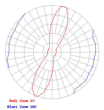 | ||||||||||||||||||
| Azimuth | Ratio | Azimuth | Ratio | Azimuth | Ratio | Azimuth | Ratio | ||||||||||||
| 0 | 0.633 | 10 | 0.945 | 15 | 1.000 | 20 | 0.944 | ||||||||||||
| 30 | 0.631 | 40 | 0.291 | 50 | 0.147 | 60 | 0.105 | ||||||||||||
| 70 | 0.093 | 80 | 0.094 | 90 | 0.093 | 100 | 0.091 | ||||||||||||
| 110 | 0.092 | 120 | 0.091 | 130 | 0.094 | 140 | 0.093 | ||||||||||||
| 150 | 0.096 | 160 | 0.122 | 170 | 0.189 | 180 | 0.446 | ||||||||||||
| 190 | 0.812 | 195 | 0.944 | 200 | 1.000 | 205 | 0.945 | ||||||||||||
| 210 | 0.814 | 220 | 0.448 | 230 | 0.195 | 240 | 0.126 | ||||||||||||
| 250 | 0.100 | 260 | 0.097 | 270 | 0.092 | 280 | 0.093 | ||||||||||||
| 290 | 0.093 | 300 | 0.092 | 310 | 0.095 | 320 | 0.098 | ||||||||||||
| 330 | 0.108 | 340 | 0.154 | 350 | 0.293 | ||||||||||||||
Structure Registration Number 1037006 Structure Type: GTOWER Registered To: American Towers LLC Structure Address: Highway 165 (204489) Oswichee, AL County Name: Russell County ASR Issued: 07/03/2018 Date Built: 11/01/1995 Site Elevation: 103.6 m (340 ft.) Structure Height: 145 m (476 ft.) Height Overall: 146.9 m (482 ft.) Overall Height AMSL: 250.5 m (822 ft.) FAA Determination: 06/29/2018 FAA Study #: 2018-ASO-5257-OE FAA Circular #: 70/7460-1L Paint & Light FAA Chapters: 4, 8, 12 OM&L to remain the same as prior study = A MED-DUAL SYSTEM 32-15-23.9 N 85-00-08.6 W (NAD 83) 32-15-23.4 N 85-00-08.9 W (Converted to NAD 27) |
Po Box 11409 Chattanooga, TN 37401 Phone: 423-468-5100 Limited Liability Company | Title: Coo Date: 05/29/2020 Application Certifier DIGITAL NETWORKS-SOUTHEAST, LLC Digital Networks-southeast, Llc Chattanooga, TN 37401 Applicant Jeremy D Ruck, PE Jeremy Ruck & Associates, Inc. Ps Box 415 Canton, IL 61520 Consulting Engineer Aaron P. Shainis Shainis & Peltzman, Chartered 1850 M St. Nw Suite 240 Washington, DC 20036 FCC Legal Counsel | |||||||||||||||||