
FCCInfo.com
A Service of Cavell, Mertz & Associates, Inc.
(855) FCC-INFO
|
|
K33PA-D from 01/15/2010 K33PA-D from 07/09/1990 |
|
|
||||||||||||||||||||||||||||||
|
|
Status: License Application Accepted: 07/09/2020 License Expires: 04/01/2022 File Number: -0000117470 FCC Website Links: LMS Facility Details This Application Other K33PA-D Applications Including Superseded Applications Mailing Address Correspondence for K33PA-D Correspondence related to application -0000117470 Service Contour - Open Street Map or USGS Map (51 dBu) Service Contour - KML / Google Earth (51 dBu) Rabbit Ears Info Search for K33PA-D Site Location: 40-35-28.0 N 103-02-24.7 W (NAD 83) Site Location: 40-35-28.0 N 103-02-23.0 W (Converted to NAD 27) ERP: 0.395 kW Polarization: Horizontally polarized Electrical Beam Tilt: 1.75 degrees R/C AGL: 124 m (407 ft.) R/C AMSL: 1499 m (4918 ft.) Emission Mask: Simple Site Elevation: 1375 m. (4511 ft.) Height Overall*: 128 m (420 ft.) (* As Filed In This Application, may differ from ASR Data, Below.) Directional Antenna - Antenna Make/Model: Scala 1X1KBBU Antenna ID: 20717 Polarization: Horizontally polarized
| ||||||||||||||||||||||||||||||||
| Antenna Data for Antenna Id: 20717 K33PA-D LD File: -0000117470 Scala - 1X1KBBU Service: LD Standard Pattern: Y Pattern and Field Values Include a 270° Clockwise Rotation | 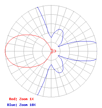 | ||||||||||||||||||||||||||||||||
| Azimuth | Ratio | Azimuth | Ratio | Azimuth | Ratio | Azimuth | Ratio | ||||||||||||||||||||||||||
| 0 | 0.030 | 10 | 0.040 | 20 | 0.050 | 30 | 0.050 | ||||||||||||||||||||||||||
| 40 | 0.040 | 50 | 0.030 | 60 | 0.020 | 70 | 0.060 | ||||||||||||||||||||||||||
| 80 | 0.100 | 90 | 0.100 | 100 | 0.100 | 110 | 0.060 | ||||||||||||||||||||||||||
| 120 | 0.020 | 130 | 0.030 | 140 | 0.040 | 150 | 0.050 | ||||||||||||||||||||||||||
| 160 | 0.050 | 170 | 0.040 | 180 | 0.030 | 190 | 0.050 | ||||||||||||||||||||||||||
| 200 | 0.130 | 210 | 0.270 | 220 | 0.400 | 230 | 0.540 | ||||||||||||||||||||||||||
| 240 | 0.700 | 250 | 0.860 | 260 | 0.960 | 270 | 1.000 | ||||||||||||||||||||||||||
| 280 | 0.960 | 290 | 0.860 | 300 | 0.700 | 310 | 0.540 | ||||||||||||||||||||||||||
| 320 | 0.400 | 330 | 0.270 | 340 | 0.130 | 350 | 0.050 | ||||||||||||||||||||||||||
Structure Registration Number 1025568 Structure Type: TOWER Registered To: LOGAN COUNTY BOARD OF COMMISSIONERS Structure Address: N Reiradon Hill , 9.5 Mi E Of Sterling, Co Sterling, CO County Name: Logan County ASR Issued: 04/08/2014 Date Built: 11/09/2000 Site Elevation: 1375 m (4511 ft.) Structure Height: 121.9 m (400 ft.) Height Overall: 128 m (420 ft.) Overall Height AMSL: 1503 m (4931 ft.) FAA Determination: 09/21/2000 FAA Study #: 00-ANM-1661-OE FAA Circular #: 70/7460-1K Paint & Light FAA Chapters: 4, 6, 12 PRIOR FAA 97-ANM-0792-OE 40-35-28.0 N 103-02-24.7 W (NAD 83) 40-35-28.0 N 103-02-23.0 W (Converted to NAD 27) |
315 Main Street Suite 2 Sterling, CO 80751 Phone: 970-522-0888 Government Entity | Title: Chief Operator Date: 07/09/2020 Application Certifier BOARD OF LOGAN COUNTY COMMISSIONERS Board Of Logan County Commissioners 315 Main Street Suite 2 Sterling, CO 80751 Applicant EDWARD R LAKE Rf Systems Llc 323 W. 4th Ave Yuma, CO 80759 CHIEF OPERATOR | |||||||||||||||||||||||||||||||