
FCCInfo.com
A Service of Cavell, Mertz & Associates, Inc.
(855) FCC-INFO
|
|
WJGC-LD from 09/22/2011 |
|
|
||||||||||||||||
|
|
Status: License Application Accepted: 07/13/2020 License Expires: 12/01/2020 File Number: -0000117659 FCC Website Links: LMS Facility Details This Application Other WJGC-LD Applications Including Superseded Applications Mailing Address Correspondence for WJGC-LD Correspondence related to application -0000117659 Service Contour - Open Street Map or USGS Map (51 dBu) Service Contour - KML / Google Earth (51 dBu) Rabbit Ears Info Search for WJGC-LD Site Location: 35-04-12.5 N 77-24-33.5 W (NAD 83) Site Location: 35-04-11.9 N 77-24-34.6 W (Converted to NAD 27) ERP: 5.02 kW Polarization: Horizontally polarized R/C AGL: 47.8 m (157 ft.) R/C AMSL: 60 m (197 ft.) Emission Mask: Full Service Site Elevation: 12.2 m. (40 ft.) Height Overall*: 94.5 m (310 ft.) (* As Filed In This Application, may differ from ASR Data, Below.) Directional Antenna - Antenna Make/Model: Scala PR-TV x4 Array 2@0 2@180 Antenna ID: 1007067 Polarization: Horizontally polarized | ||||||||||||||||||
| Antenna Data for Antenna Id: 1007067 WJGC-LD LD File: -0000117659 Scala - PR-TV x4 Array 2@0 2@180 Service: LD Standard Pattern: N | 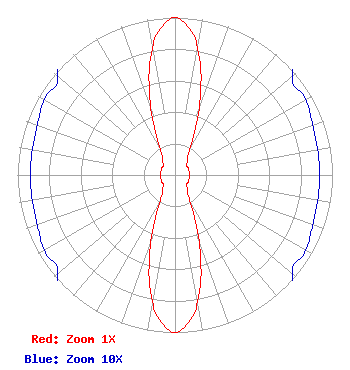 | ||||||||||||||||||
| Azimuth | Ratio | Azimuth | Ratio | Azimuth | Ratio | Azimuth | Ratio | ||||||||||||
| 0 | 1.000 | 5 | 0.944 | 10 | 0.814 | 20 | 0.447 | ||||||||||||
| 30 | 0.190 | 40 | 0.125 | 50 | 0.097 | 60 | 0.096 | ||||||||||||
| 70 | 0.093 | 80 | 0.092 | 90 | 0.092 | 100 | 0.092 | ||||||||||||
| 110 | 0.093 | 120 | 0.096 | 130 | 0.097 | 140 | 0.125 | ||||||||||||
| 150 | 0.190 | 160 | 0.447 | 170 | 0.814 | 175 | 0.944 | ||||||||||||
| 180 | 1.000 | 185 | 0.944 | 190 | 0.814 | 200 | 0.447 | ||||||||||||
| 210 | 0.190 | 220 | 0.125 | 230 | 0.097 | 240 | 0.096 | ||||||||||||
| 250 | 0.093 | 260 | 0.092 | 270 | 0.092 | 280 | 0.092 | ||||||||||||
| 290 | 0.093 | 300 | 0.096 | 310 | 0.097 | 320 | 0.125 | ||||||||||||
| 330 | 0.190 | 340 | 0.447 | 350 | 0.814 | 355 | 0.944 | ||||||||||||
Structure Registration Number 1255346 Structure Type: TOWER Registered To: Alltel Corporation Structure Address: 170 Chinquapin Chapel Road (phillips Crossroads 196407876) Trenton, NC County Name: Jones County ASR Issued: 02/05/2019 Date Built: 02/02/2007 Site Elevation: 12.2 m (40 ft.) Structure Height: 91.4 m (300 ft.) Height Overall: 94.5 m (310 ft.) Overall Height AMSL: 106.7 m (350 ft.) FAA Determination: 04/26/2006 FAA Study #: 2006-ASO-2339-OE FAA Circular #: 70/7460-1K Paint & Light FAA Chapters: 4, 8, 12 Removed expiration date from determination. Scenario 1./jjs/case#635066 35-04-12.5 N 77-24-33.5 W (NAD 83) 35-04-11.9 N 77-24-34.6 W (Converted to NAD 27) |
Chattanooga, TN 37401 Phone: 423-468-5100 Applicant | Title: Coo Date: 07/13/2020 Application Certifier Digital Networks-Southeast, LLC Digital Networks-southeast, Llc Chattanooga, TN 37401 Applicant Jeremy D Ruck, PE Jeremy Ruck & Associates, Inc. Canton, IL 61520 Consulting Engineer Aaron P Shainis, Esq Shainis & Peltzman, Chartered 1850 M Street Nw Suite 240 Washington, DC 20036 FCC Counsel | |||||||||||||||||