
FCCInfo.com
A Service of Cavell, Mertz & Associates, Inc.
(855) FCC-INFO
|
|
WLPX-TV from 10/27/1988 |
Post-repack Channel 18 Virtual Channel 29 |  |
|
|||||||||||||||
|
|
Repacking Information: Pre-Repack Channel: 39 Post-Repack Channel: 18 Post-Repack ERP: 636 kW Phase: 6 Completion Deadline: 10/18/2019 Upstream/Downstream Dependencies Other Linked Stations Find nearby TV Facilities Status: License Application Accepted: 07/17/2020 License Expires: 10/01/2020 File Number: -0000118002 FCC Website Links: LMS Facility Details This Application Other WLPX-TV Applications Including Superseded Applications Mailing Address Correspondence for WLPX-TV Correspondence related to application -0000118002 Service Contour - Open Street Map or USGS Map (41 dBu) Service Contour - KML / Google Earth (41 dBu) Public Inspection Files Rabbit Ears Info Search for WLPX-TV Site Location: 38-30-21.1 N 82-12-32.3 W (NAD 83) Site Location: 38-30-20.8 N 82-12-32.8 W (Converted to NAD 27) ERP: 765 kW Polarization: Elliptically polarized HAAT: 327.2 m (1073 ft.) Electrical Beam Tilt: 0.75 degrees R/C AGL: 259.1 m (850 ft.) R/C AMSL: 555.3 m (1822 ft.) Site Elevation: 296.2 m. (972 ft.) Height Overall*: 353.3 m (1159 ft.) (* As Filed In This Application, may differ from ASR Data, Below.) Directional Antenna - Antenna Make/Model: Electronics Research Inc. ATW26H3-ESC170-18H Antenna ID: 1007097 Polarization: Elliptically polarized | ||||||||||||||||||
| Antenna Data for Antenna Id: 1007097 WLPX-TV DT File: -0000118002 Electronics Research Inc. - ATW26H3-ESC170-18H Service: DT Standard Pattern: N | 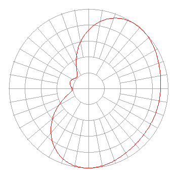 | ||||||||||||||||||
| Azimuth | Ratio | Azimuth | Ratio | Azimuth | Ratio | Azimuth | Ratio | ||||||||||||
| 0 | 0.733 | 10 | 0.854 | 20 | 0.940 | 30 | 0.987 | ||||||||||||
| 40 | 1.000 | 50 | 0.988 | 60 | 0.963 | 70 | 0.936 | ||||||||||||
| 80 | 0.917 | 90 | 0.905 | 100 | 0.900 | 110 | 0.899 | ||||||||||||
| 120 | 0.900 | 130 | 0.905 | 140 | 0.917 | 150 | 0.936 | ||||||||||||
| 160 | 0.963 | 170 | 0.988 | 180 | 1.000 | 190 | 0.987 | ||||||||||||
| 200 | 0.940 | 210 | 0.854 | 220 | 0.733 | 230 | 0.588 | ||||||||||||
| 240 | 0.437 | 250 | 0.302 | 260 | 0.218 | 270 | 0.207 | ||||||||||||
| 280 | 0.232 | 290 | 0.245 | 300 | 0.232 | 310 | 0.207 | ||||||||||||
| 320 | 0.218 | 330 | 0.302 | 340 | 0.437 | 350 | 0.588 | ||||||||||||
Structure Registration Number 1234025 Structure Type: Registered To: Nexstar Media Inc. Structure Address: Barkers Ridge Road Huntington, WV County Name: Cabell County ASR Issued: 05/28/2021 Date Built: 07/07/2015 Site Elevation: 296.2 m (972 ft.) Structure Height: 352 m (1155 ft.) Height Overall: 353.3 m (1159 ft.) Overall Height AMSL: 649.5 m (2131 ft.) FAA Determination: 07/19/2000 FAA Study #: 00-AEA-0363-OE FAA Circular #: 70/7460-1K Paint & Light FAA Chapters: 4, 9, 12 PRIOR FAA 99-AEA-1924-OE 38-30-21.1 N 82-12-32.3 W (NAD 83) 38-30-20.8 N 82-12-32.8 W (Converted to NAD 27) |
312 Walnut Street 28th Floor Cincinnati, OH 45202 Phone: 513-977-3000 Limited Liability Company | Title: Vp, Engineering Date: 07/17/2020 Application Certifier ION MEDIA CHARLESTON LICENSE, INC. Ion Media Charleston License, Inc. 601 Clearwater Park Road West Palm Beach, FL 33401 Applicant Shea Clark Ion Media Networks, Inc. 14444 66th Street N Clearwater, FL 33764 VP, Engineering Bianca Frye Ion Media Networks, Inc. 601 Clearwater Park Road West Palm Beach, FL 33401 Paralegal | |||||||||||||||||