
FCCInfo.com
A Service of Cavell, Mertz & Associates, Inc.
(855) FCC-INFO
|
|
|
|
|
||||||||||||||||
|
|
Status: License Application Accepted: 07/20/2020 License Expires: 10/03/2022 File Number: -0000118136 FCC Website Links: LMS Facility Details This Application Other K09EP-D Applications Including Superseded Applications Mailing Address Correspondence for K09EP-D Correspondence related to application -0000118136 Service Contour - Open Street Map or USGS Map (48 dBu) Service Contour - KML / Google Earth (48 dBu) Rabbit Ears Info Search for K09EP-D Site Location: 35-07-09.1 N 107-54-04.2 W (NAD 83) Site Location: 35-07-09.0 N 107-54-02.0 W (Converted to NAD 27) ERP: 0.009 kW Polarization: Horizontally polarized R/C AGL: 10.6 m (35 ft.) R/C AMSL: 2168.6 m (7115 ft.) Emission Mask: Stringent Site Elevation: 2158 m. (7080 ft.) Height Overall*: 22.9 m (75 ft.) (* As Filed In This Application, may differ from ASR Data, Below.) Directional Antenna - Antenna Make/Model: Channel Master ODDK09EP Antenna ID: 18610 Polarization: Horizontally polarized
| ||||||||||||||||||
| Antenna Data for Antenna Id: 18610 K09EP-D LD File: -0000118136 Channel Master - ODDK09EP Service: LD Standard Pattern: Y | 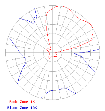 | ||||||||||||||||||
| Azimuth | Ratio | Azimuth | Ratio | Azimuth | Ratio | Azimuth | Ratio | ||||||||||||
| 0 | 0.930 | 10 | 1.000 | 20 | 0.985 | 30 | 0.920 | ||||||||||||
| 40 | 0.915 | 50 | 0.981 | 55 | 1.000 | 60 | 0.991 | ||||||||||||
| 70 | 0.882 | 73 | 0.820 | 80 | 0.240 | 90 | 0.061 | ||||||||||||
| 100 | 0.065 | 110 | 0.082 | 120 | 0.115 | 130 | 0.125 | ||||||||||||
| 140 | 0.115 | 150 | 0.100 | 160 | 0.080 | 170 | 0.080 | ||||||||||||
| 180 | 0.080 | 190 | 0.090 | 200 | 0.120 | 210 | 0.140 | ||||||||||||
| 220 | 0.120 | 230 | 0.095 | 240 | 0.075 | 250 | 0.060 | ||||||||||||
| 260 | 0.060 | 270 | 0.069 | 280 | 0.080 | 290 | 0.100 | ||||||||||||
| 300 | 0.140 | 310 | 0.120 | 320 | 0.090 | 330 | 0.078 | ||||||||||||
| 340 | 0.160 | 350 | 0.770 | ||||||||||||||||
Structure Registration Number 1216858 Structure Type: TOWER Registered To: Regents of the University of New Mexico & the Board of Education of Albuquerque, N.M. Structure Address: 4.63 Km Due South Of Grants Municipal Airport Atop Of Cerrito Colorado Grants, NM County Name: Cibola County ASR Issued: 09/01/2000 Date Built: 09/15/2000 Site Elevation: 2158 m (7080 ft.) Structure Height: 18.3 m (60 ft.) Height Overall: 22.9 m (75 ft.) Overall Height AMSL: 2180.9 m (7155 ft.) FAA Determination: 08/17/2000 FAA Study #: 00-ASW-4068-OE Paint & Light FAA Chapters: NONE Removed expiration date from determination. Scenario 1./jjs/case#635066 35-07-09.1 N 107-54-04.2 W (NAD 83) 35-07-09.0 N 107-54-02.0 W (Converted to NAD 27) |
545 E. John Carpenter Freeway Suite 700 Irving, TX 75062 Phone: 972-373-8800 Corporation | Title: General Counsel Date: 07/20/2020 Application Certifier Nexstar Broadcasting, Inc. 545 E. John Carpenter Freeway Suite 700 Irving, TX 75062 Applicant Gregory Best Greg Best Consulting, Inc. 16100 Outlook Ave. Stilwell, KS 66085 Consulting Engineer Elizabeth Ryder Nexstar Broadcasting, Inc. 545 E. John Carpenter Freeway Suite 700 Irving, TX 75062 General Counsel | |||||||||||||||||