
FCCInfo.com
A Service of Cavell, Mertz & Associates, Inc.
(855) FCC-INFO
|
|
|
|
|
||||||||||||||||
|
|
Status: Construction Permit Application Accepted: 03/24/2022 K28QU-D CP Expires: 03/25/2025 File Number: BNPDTL-20090825BFA Prefix Type: This is BNPDTL FCC Website Links: LMS Facility Details This Application Other K28QU-D Applications Including Superseded Applications Mailing Address Correspondence for K28QU-D Correspondence related to application BNPDTL-20090825BFA Service Contour - Open Street Map or USGS Map (51 dBu) Service Contour - KML / Google Earth (51 dBu) Rabbit Ears Info Search for K28QU-D Site Location: 44-00-03.4 N 123-06-27.3 W (NAD 83) Site Location: 44-00-04.0 N 123-06-23.0 W (Converted to NAD 27) ERP: 1 kW Polarization: Horizontally polarized R/C AGL: 34 m (112 ft.) R/C AMSL: 448.6 m (1472 ft.) Emission Mask: Full Service Site Elevation: 414.6 m. (1360 ft.) Height Overall*: 47.2 m (155 ft.) (* As Filed In This Application, may differ from ASR Data, Below.) Directional Antenna - Antenna Make/Model: ELTI ELTI UHF Panel Antenna ID: 1008435 Polarization: Horizontally polarized | ||||||||||||||||||
| Antenna Data for Antenna Id: 1008435 K28QU-D LD File: BNPDTL-20090825BFA ELTI - ELTI UHF Panel Service: LD Standard Pattern: Y Pattern and Field Values Include a 180° Clockwise Rotation | 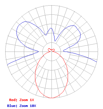 | ||||||||||||||||||
| Azimuth | Ratio | Azimuth | Ratio | Azimuth | Ratio | Azimuth | Ratio | ||||||||||||
| 0 | 0.050 | 10 | 0.033 | 20 | 0.025 | 30 | 0.056 | ||||||||||||
| 40 | 0.073 | 50 | 0.074 | 60 | 0.072 | 70 | 0.060 | ||||||||||||
| 80 | 0.033 | 90 | 0.029 | 100 | 0.082 | 110 | 0.158 | ||||||||||||
| 120 | 0.263 | 130 | 0.389 | 140 | 0.537 | 150 | 0.700 | ||||||||||||
| 160 | 0.851 | 170 | 0.955 | 180 | 1.000 | 190 | 0.955 | ||||||||||||
| 200 | 0.851 | 210 | 0.700 | 220 | 0.531 | 230 | 0.367 | ||||||||||||
| 240 | 0.232 | 250 | 0.132 | 260 | 0.052 | 270 | 0.028 | ||||||||||||
| 280 | 0.053 | 290 | 0.075 | 300 | 0.087 | 310 | 0.090 | ||||||||||||
| 320 | 0.084 | 330 | 0.062 | 340 | 0.038 | 350 | 0.044 | ||||||||||||
Structure Registration Number 1257299 Structure Type: TOWER Registered To: Day Management Corporation dba Day Wireless Systems Structure Address: Blanton Heights Eugene, OR County Name: Lane County ASR Issued: 02/26/2007 Date Built: 09/11/2007 Site Elevation: 414.6 m (1360 ft.) Structure Height: 47.2 m (155 ft.) Height Overall: 47.2 m (155 ft.) Overall Height AMSL: 461.8 m (1515 ft.) FAA Determination: 02/13/2007 FAA Study #: 2007-ANM-410-OE Paint & Light FAA Chapters: NONE 44-00-03.4 N 123-06-27.3 W (NAD 83) 44-00-04.0 N 123-06-23.0 W (Converted to NAD 27) |
715 Broadway Suite 320 Santa Monica, CA 90401 Phone: 323-653-3855 Corporation | Title: President Date: 03/24/2022 Application Certifier Point Broadcasting Company Point Broadcasting Company 715 Broadway Suite 320 Santa Monica, CA 90401 Applicant David D. Oxenford Wilkinson Barker Knauer, Llp 1800 M Street, Nw Suite 800n Washington, DC 20036 DARRYL K. Delawder Delawder Communications, Inc. P.o. Box 1095 Ashburn, VA 20146-1095 | |||||||||||||||||