
FCCInfo.com
A Service of Cavell, Mertz & Associates, Inc.
(855) FCC-INFO
|
|
WUTB from 12/28/1992 WUTB from 01/23/1987 |
RF spectrum relinquished in the spectrum auction Virtual Channel 24 |  |
|
|||||||||||||||
|
|
WUTB is a channel sharing guest of WBFF, Baltimore, Maryland Repacking Information: Channel 41 was relinquished in the spectrum auction Status: License Application Accepted: 07/30/2020 License Expires: 10/01/2020 File Number: -0000119337 FCC Website Links: LMS Facility Details This Application Other WUTB Applications Including Superseded Applications Mailing Address Correspondence for WUTB Correspondence related to application -0000119337 Service Contour - Open Street Map or USGS Map (41 dBu) Service Contour - KML / Google Earth (41 dBu) Public Inspection Files History Cards for WUTB Rabbit Ears Info Search for WUTB Site Location: 39-20-10.4 N 76-38-57.9 W (NAD 83) Site Location: 39-20-10.0 N 76-38-59.0 W (Converted to NAD 27) ERP: 420 kW Polarization: Horizontally polarized HAAT: 372.8 m (1223 ft.) Electrical Beam Tilt: 0.9 degrees R/C AGL: 374.8 m (1230 ft.) R/C AMSL: 456.8 m (1499 ft.) Emission Mask: Simple Site Elevation: 82 m. (269 ft.) Height Overall*: 390.1 m (1280 ft.) (* As Filed In This Application, may differ from ASR Data, Below.) Directional Antenna - Antenna Make/Model: DIELECTRIC TUD-C5SP-10/36SPH-1-B Antenna ID: 1006566 Polarization: Horizontally polarized | ||||||||||||||||||
| Antenna Data for Antenna Id: 1006566 WUTB DT File: -0000119337 DIELECTRIC - TUD-C5SP-10/36SPH-1-B Service: DT Standard Pattern: Y Pattern and Field Values Include a 30° Clockwise Rotation | 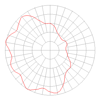 | ||||||||||||||||||
| Azimuth | Ratio | Azimuth | Ratio | Azimuth | Ratio | Azimuth | Ratio | ||||||||||||
| 0 | 0.593 | 10 | 0.537 | 20 | 0.440 | 30 | 0.391 | ||||||||||||
| 40 | 0.362 | 50 | 0.355 | 60 | 0.395 | 70 | 0.402 | ||||||||||||
| 80 | 0.361 | 90 | 0.356 | 100 | 0.385 | 110 | 0.425 | ||||||||||||
| 120 | 0.517 | 130 | 0.589 | 140 | 0.594 | 150 | 0.667 | ||||||||||||
| 160 | 0.842 | 170 | 0.955 | 180 | 0.923 | 190 | 0.859 | ||||||||||||
| 200 | 0.928 | 210 | 1.000 | 220 | 0.928 | 230 | 0.859 | ||||||||||||
| 240 | 0.917 | 250 | 0.929 | 260 | 0.863 | 270 | 0.905 | ||||||||||||
| 280 | 0.996 | 282 | 1.000 | 290 | 0.950 | 300 | 0.861 | ||||||||||||
| 310 | 0.906 | 320 | 0.960 | 330 | 0.874 | 340 | 0.699 | ||||||||||||
| 350 | 0.598 | ||||||||||||||||||
Structure Registration Number 1044237 Structure Type: GTOWER Registered To: CUNNINGHAM COMMUNICATIONS, INC Structure Address: 3900 Hooperave Baltimore, MD County Name: Baltimore city ASR Issued: 12/05/2012 Date Built: 01/01/1987 Site Elevation: 82 m (269 ft.) Structure Height: 389.2 m (1277 ft.) Height Overall: 390.1 m (1280 ft.) Overall Height AMSL: 472.1 m (1549 ft.) FAA Determination: 11/30/2012 FAA Study #: 2012-AEA-4895-OE FAA Circular #: 70/7460-1J Paint & Light FAA Chapters: 4, 7, 13 OM&L to remain the same as prior study = 24-HR HI-STROBES 39-20-10.4 N 76-38-57.9 W (NAD 83) 39-20-10.0 N 76-38-59.0 W (Converted to NAD 27) |
Po Box 5120 Avon, CO 81620 Phone: 970-628-9881 Limited Liability Company | Application Certifier DEERFIELD MEDIA (BALTIMORE) LICENSEE, LLC Deerfield Media (baltimore) Licensee, Llc 1735 York Avenue #38a New York, NY 10128 Applicant Scott R. Flick, Esq Pillsbury Winthrop Shaw Pittman Llp 1200 Seventeenth Street, Nw Washington, DC 20036 FCC Counsel | |||||||||||||||||
| |||||||||||||||||||