
FCCInfo.com
A Service of Cavell, Mertz & Associates, Inc.
(855) FCC-INFO
|
|
KXVU-LD from 08/10/2005 KXVU-LD from 07/25/2005 KXVU-LD from 07/26/2002 |
|
|
||||||||||||||||
|
|
Status: License Application Accepted: 11/09/2020 License Expires: 12/01/2022 File Number: -0000125684 FCC Website Links: LMS Facility Details This Application Other KXVU-LD Applications Including Superseded Applications Mailing Address Correspondence for KXVU-LD Correspondence related to application -0000125684 Service Contour - Open Street Map or USGS Map (43 dBu) Service Contour - KML / Google Earth (43 dBu) Rabbit Ears Info Search for KXVU-LD Site Location: 39-57-42.7 N 121-42-43.1 W (NAD 83) Site Location: 39-57-43.1 N 121-42-39.2 W (Converted to NAD 27) ERP: 0.1 kW Polarization: Horizontally polarized R/C AGL: 60 m (197 ft.) R/C AMSL: 1134.4 m (3722 ft.) Emission Mask: Full Service Site Elevation: 1074.4 m. (3525 ft.) Height Overall*: 123.1 m (404 ft.) (* As Filed In This Application, may differ from ASR Data, Below.) Directional Antenna - Antenna Make/Model: Scala CL-26 Antenna ID: 20783 Polarization: Horizontally polarized | ||||||||||||||||||
| Antenna Data for Antenna Id: 20783 KXVU-LD LD File: -0000125684 Scala - CL-26 Service: LD Standard Pattern: Y Pattern and Field Values Include a 200° Clockwise Rotation | 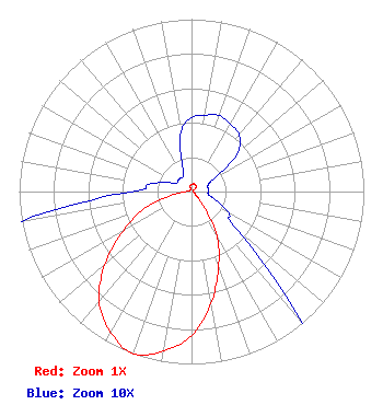 | ||||||||||||||||||
| Azimuth | Ratio | Azimuth | Ratio | Azimuth | Ratio | Azimuth | Ratio | ||||||||||||
| 0 | 0.043 | 10 | 0.045 | 20 | 0.047 | 30 | 0.045 | ||||||||||||
| 40 | 0.043 | 50 | 0.035 | 60 | 0.015 | 70 | 0.010 | ||||||||||||
| 80 | 0.010 | 90 | 0.010 | 100 | 0.010 | 110 | 0.015 | ||||||||||||
| 120 | 0.025 | 130 | 0.035 | 140 | 0.105 | 150 | 0.295 | ||||||||||||
| 160 | 0.460 | 170 | 0.655 | 180 | 0.835 | 190 | 0.940 | ||||||||||||
| 200 | 1.000 | 210 | 0.940 | 220 | 0.835 | 230 | 0.655 | ||||||||||||
| 240 | 0.460 | 250 | 0.295 | 260 | 0.105 | 270 | 0.035 | ||||||||||||
| 280 | 0.025 | 290 | 0.015 | 300 | 0.010 | 310 | 0.010 | ||||||||||||
| 320 | 0.010 | 330 | 0.010 | 340 | 0.015 | 350 | 0.035 | ||||||||||||
Structure Registration Number 1049506 Structure Type: GTOWER Registered To: SBA GC Towers, LLC Structure Address: 11045 Cohasset Rd (ca15878-a #1) Chico, CA County Name: Butte County ASR Issued: 06/21/2021 Date Built: 11/01/1998 Site Elevation: 1074.4 m (3525 ft.) Structure Height: 122.2 m (401 ft.) Height Overall: 123.1 m (404 ft.) Overall Height AMSL: 1197.5 m (3929 ft.) FAA Determination: 06/11/2021 FAA Study #: 2021-AWP-5876-OE FAA Circular #: 70/7460-1M Paint & Light FAA Chapters: 3, 4, 5, 15 PRIOR STUDY 2014-AWP-838-OE 39-57-42.7 N 121-42-43.2 W (NAD 83) 39-57-43.1 N 121-42-39.3 W (Converted to NAD 27) |
10706 Beaver Dam Road Cockeysville, MD 21030 Phone: 410-568-1500 Limited Liability Company | Title: Cfo Date: 11/09/2020 Application Certifier SINCLAIR-CALIFORNIA LICENSEE, LLC Sinclair-california Licensee, Llc 10706 Beaver Dam Road Cockeysville, MD 21030 Applicant John E. Hidle, PE Carl T. Jones Corporation 7901 Yarnwood Court Springfield, VA 22153-2827 Consulting Engineer Paul A. Cicelski, Esq Lerman Senter Pllc 2001 L St Nw Suite 400 Washington, DC 20036 | |||||||||||||||||