
FCCInfo.com
A Service of Cavell, Mertz & Associates, Inc.
(855) FCC-INFO
|
|
|
Post-repack Channel 27 Virtual Channel 18 |  |
|
||||||||||||||||||||||||||||||
|
|
Repacking Information: Pre-Repack Channel: 18 Post-Repack Channel: 27 Post-Repack ERP: 915 kW Phase: 6 Completion Deadline: 10/18/2019 Upstream/Downstream Dependencies Other Linked Stations Find nearby TV Facilities Status: License Application Accepted: 09/17/2020 License Expires: 12/01/2021 File Number: -0000121792 FCC Website Links: LMS Facility Details This Application Other WVTV Applications Including Superseded Applications Mailing Address Correspondence for WVTV Correspondence related to application -0000121792 Service Contour - Open Street Map or USGS Map (41 dBu) Service Contour - KML / Google Earth (41 dBu) Public Inspection Files Rabbit Ears Info Search for WVTV Site Location: 43-05-48.0 N 87-54-18.0 W (NAD 83) Site Location: 43-05-48.0 N 87-54-17.7 W (Converted to NAD 27) ERP: 1000 kW Polarization: Elliptically polarized HAAT: 318 m (1043 ft.) Electrical Beam Tilt: 0.75 degrees R/C AGL: 323.9 m (1063 ft.) R/C AMSL: 516.2 m (1694 ft.) Site Elevation: 192.3 m. (631 ft.) Height Overall*: 335.6 m (1101 ft.) (* As Filed In This Application, may differ from ASR Data, Below.) Directional Antenna - Antenna Make/Model: DIELECTRIC TFU-29ETT/VP-R 4C170 Antenna ID: 1007341 Polarization: Elliptically polarized | |||||||||||||||||||||||||||||||||
| Antenna Data for Antenna Id: 1007341 WVTV DT File: -0000121792 DIELECTRIC - TFU-29ETT/VP-R 4C170 Service: DT Standard Pattern: N | 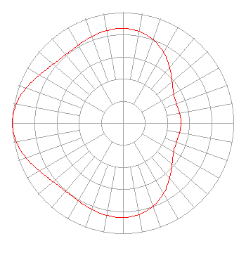 | |||||||||||||||||||||||||||||||||
| Azimuth | Ratio | Azimuth | Ratio | Azimuth | Ratio | Azimuth | Ratio | |||||||||||||||||||||||||||
| 0 | 0.854 | 10 | 0.840 | 20 | 0.799 | 30 | 0.734 | |||||||||||||||||||||||||||
| 40 | 0.654 | 50 | 0.579 | 60 | 0.528 | 70 | 0.513 | |||||||||||||||||||||||||||
| 80 | 0.519 | 90 | 0.524 | 100 | 0.519 | 110 | 0.513 | |||||||||||||||||||||||||||
| 120 | 0.528 | 130 | 0.579 | 140 | 0.654 | 150 | 0.734 | |||||||||||||||||||||||||||
| 160 | 0.799 | 170 | 0.840 | 180 | 0.854 | 190 | 0.847 | |||||||||||||||||||||||||||
| 200 | 0.828 | 210 | 0.810 | 220 | 0.805 | 230 | 0.824 | |||||||||||||||||||||||||||
| 240 | 0.869 | 250 | 0.929 | 260 | 0.980 | 270 | 1.000 | |||||||||||||||||||||||||||
| 280 | 0.980 | 290 | 0.929 | 300 | 0.869 | 310 | 0.824 | |||||||||||||||||||||||||||
| 320 | 0.805 | 330 | 0.810 | 340 | 0.828 | 350 | 0.847 | |||||||||||||||||||||||||||
Structure Registration Number 1045308 Structure Type: TOWER Registered To: WCGV Licensee, LLC Structure Address: 4400 N Humboldt Ave Milwaukee, WI County Name: Milwaukee County ASR Issued: 01/11/2017 Date Built: 11/05/1980 Site Elevation: 192.3 m (631 ft.) Structure Height: 335.6 m (1101 ft.) Height Overall: 335.6 m (1101 ft.) Overall Height AMSL: 527.9 m (1732 ft.) FAA Determination: 04/15/1998 FAA Study #: 98-AGL-1610-OE Paint & Light FAA Chapters: 1, 3, 8, 17, 21 REF STUDY #97-AGL-5272-OE. 43-05-48.0 N 87-54-18.0 W (NAD 83) 43-05-48.0 N 87-54-17.7 W (Converted to NAD 27) |
1200 Seventeenth Street Nw Washington Dc, DC 20036 Phone: 202-663-8195 Corporation | Title: Cfo Date: 09/17/2020 Application Certifier WVTV LICENSEE, INC. Wvtv Licensee, Inc. 10706 Beaver Dam Road Cockeysville, MD 21030 Applicant Paul A. Cicelski, Esq Lerman Senter Pllc 2001 L St. Nw Suite 400 Washington, DC 20036 John E. Hidle, PE Carl T. Jones Corporation 7901 Yarnwood Court Springfield, VA 22153 Consulting Engineer | ||||||||||||||||||||||||||||||||
|
| |||||||||||||||||||||||||||||||||