
FCCInfo.com
A Service of Cavell, Mertz & Associates, Inc.
(855) FCC-INFO
|
|
K22OK-D from 03/27/2012 |
|
|
||||||||||||||||
|
|
Status: License Application Accepted: 09/14/2020 License Expires: 08/01/2022 File Number: -0000121629 FCC Website Links: LMS Facility Details This Application Other K22OK-D Applications Including Superseded Applications Mailing Address Correspondence for K22OK-D Correspondence related to application -0000121629 Service Contour - Open Street Map or USGS Map (51 dBu) Service Contour - KML / Google Earth (51 dBu) Rabbit Ears Info Search for K22OK-D Site Location: 30-56-23.4 N 96-35-06.5 W (NAD 83) Site Location: 30-56-22.7 N 96-35-05.6 W (Converted to NAD 27) ERP: 3.2 kW Polarization: Horizontally polarized R/C AGL: 45.7 m (150 ft.) R/C AMSL: 152.4 m (500 ft.) Emission Mask: Full Service Site Elevation: 106.7 m. (350 ft.) Height Overall*: 102.4 m (336 ft.) (* As Filed In This Application, may differ from ASR Data, Below.) Directional Antenna - Antenna Make/Model: Scala PR-TV x2 Array 1@150 1@310 Antenna ID: 1007325 Polarization: Horizontally polarized | ||||||||||||||||||
| Antenna Data for Antenna Id: 1007325 K22OK-D LD File: -0000121629 Scala - PR-TV x2 Array 1@150 1@310 Service: LD Standard Pattern: N | 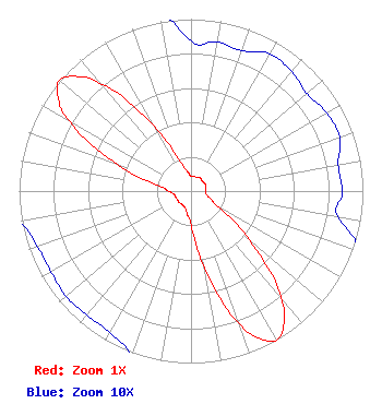 | ||||||||||||||||||
| Azimuth | Ratio | Azimuth | Ratio | Azimuth | Ratio | Azimuth | Ratio | ||||||||||||
| 0 | 0.087 | 10 | 0.088 | 20 | 0.087 | 30 | 0.092 | ||||||||||||
| 40 | 0.091 | 50 | 0.088 | 60 | 0.091 | 70 | 0.092 | ||||||||||||
| 80 | 0.087 | 90 | 0.088 | 100 | 0.087 | 110 | 0.115 | ||||||||||||
| 120 | 0.186 | 130 | 0.442 | 140 | 0.811 | 145 | 0.943 | ||||||||||||
| 150 | 1.000 | 155 | 0.945 | 160 | 0.815 | 170 | 0.455 | ||||||||||||
| 180 | 0.200 | 190 | 0.132 | 200 | 0.102 | 210 | 0.095 | ||||||||||||
| 220 | 0.094 | 230 | 0.095 | 240 | 0.094 | 250 | 0.095 | ||||||||||||
| 260 | 0.102 | 270 | 0.132 | 280 | 0.200 | 290 | 0.455 | ||||||||||||
| 300 | 0.815 | 305 | 0.945 | 310 | 1.000 | 315 | 0.943 | ||||||||||||
| 320 | 0.811 | 330 | 0.442 | 340 | 0.186 | 350 | 0.115 | ||||||||||||
Structure Registration Number 1048522 Structure Type: GTOWER Registered To: American Towers LLC Structure Address: Hwy 79 (4129) Hearne, TX County Name: Robertson County ASR Issued: 11/12/2013 Date Built: 01/01/1996 Site Elevation: 106.7 m (350 ft.) Structure Height: 97.5 m (320 ft.) Height Overall: 102.4 m (336 ft.) Overall Height AMSL: 209.1 m (686 ft.) FAA Determination: 10/22/2013 FAA Study #: 2013-ASW-7069-OE FAA Circular #: 70/7460-1K Paint & Light FAA Chapters: 4, 8, 12 PRIOR STUDY 2004-ASW-5475-OE 30-56-23.4 N 96-35-06.5 W (NAD 83) 30-56-22.7 N 96-35-05.6 W (Converted to NAD 27) |
Chattanooga, TN 37401 Phone: 423-468-5100 Limited Liability Company | Title: Coo Date: 09/14/2020 Application Certifier DIGITAL NETWORKS-SOUTHWEST, LLC Digital Networks-southwest, Llc Chattanooga, TN 37401 Applicant Jeremy D Ruck, PE Jeremy Ruck & Associates, Inc. Canton, IL 61520 Consulting Engineer Aaron P Shainis, Esq Shainis & Peltzman, Chartered 1850 M Street Nw Suite 240 Washington, DC 20036 FCC Legal Counsel | |||||||||||||||||