
FCCInfo.com
A Service of Cavell, Mertz & Associates, Inc.
(855) FCC-INFO
|
|
WLMS-LD from 09/24/1984 |
|
|
||||||||||||||||
|
|
Status: License Application Accepted: 09/21/2020 License Expires: 06/01/2021 File Number: -0000121952 FCC Website Links: LMS Facility Details This Application Other WLMS-LD Applications Including Superseded Applications Mailing Address Correspondence for WLMS-LD Correspondence related to application -0000121952 Service Contour - Open Street Map or USGS Map (51 dBu) Service Contour - KML / Google Earth (51 dBu) Rabbit Ears Info Search for WLMS-LD Site Location: 33-40-09.7 N 88-40-07.9 W (NAD 83) Site Location: 33-40-09.3 N 88-40-07.7 W (Converted to NAD 27) ERP: 15 kW Polarization: Horizontally polarized R/C AGL: 83.3 m (273 ft.) R/C AMSL: 157 m (515 ft.) Emission Mask: Full Service Site Elevation: 73.7 m. (242 ft.) Height Overall*: 106.7 m (350 ft.) (* As Filed In This Application, may differ from ASR Data, Below.) Directional Antenna - Antenna Make/Model: Kathrein 75010210 2x2 Antenna ID: 1007346 Polarization: Horizontally polarized | ||||||||||||||||||
| Antenna Data for Antenna Id: 1007346 WLMS-LD LD File: -0000121952 Kathrein - 75010210 2x2 Service: LD Standard Pattern: N Pattern and Field Values Include a 180° Clockwise Rotation | 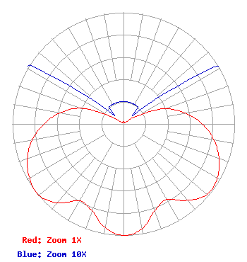 | ||||||||||||||||||
| Azimuth | Ratio | Azimuth | Ratio | Azimuth | Ratio | Azimuth | Ratio | ||||||||||||
| 0 | 0.020 | 10 | 0.020 | 20 | 0.020 | 30 | 0.020 | ||||||||||||
| 40 | 0.020 | 50 | 0.020 | 60 | 0.130 | 70 | 0.395 | ||||||||||||
| 80 | 0.560 | 90 | 0.710 | 100 | 0.825 | 110 | 0.915 | ||||||||||||
| 120 | 0.975 | 130 | 0.983 | 140 | 0.895 | 150 | 0.784 | ||||||||||||
| 160 | 0.827 | 170 | 0.955 | 180 | 1.000 | 190 | 0.945 | ||||||||||||
| 200 | 0.830 | 210 | 0.795 | 220 | 0.925 | 230 | 0.995 | ||||||||||||
| 240 | 0.975 | 250 | 0.920 | 260 | 0.835 | 270 | 0.715 | ||||||||||||
| 280 | 0.580 | 290 | 0.410 | 300 | 0.135 | 310 | 0.020 | ||||||||||||
| 320 | 0.020 | 330 | 0.020 | 340 | 0.020 | 350 | 0.020 | ||||||||||||
Structure Registration Number 1215720 Structure Type: TOWER Registered To: American Towers LLC Structure Address: 4663 Hwy 45a North (035328 / West Point) West Point, MS County Name: Clay County ASR Issued: 06/24/2016 Date Built: 10/18/2004 Site Elevation: 73.7 m (242 ft.) Structure Height: 106 m (348 ft.) Height Overall: 106.7 m (350 ft.) Overall Height AMSL: 180.4 m (592 ft.) FAA Determination: 08/12/2004 FAA Study #: 2004-ASO-4543-OE FAA Circular #: 70/7460-1K Paint & Light FAA Chapters: 4, 8, 12 PRIOR STUDY 2004-ASO-2941-OE 33-40-09.7 N 88-40-07.9 W (NAD 83) 33-40-09.3 N 88-40-07.7 W (Converted to NAD 27) |
Chattanooga, TN 37401 Phone: 202-293-0567 Limited Liability Company | Title: Coo Date: 09/21/2020 Application Certifier DIGITAL NETWORKS-SOUTHEAST, LLC Digital Networks-southeast, Llc Chattanooga, TN 37401 Applicant Jeremy D Ruck, PE Jeremy Ruck & Associates, Inc. Canton, IL 61520 Consulting Engineer Aaron P Shainis Shainis & Peltzman, Chartered 1850 M St. Nw Suite 240 Washington, DC 20036 FCC Legal Counsel | |||||||||||||||||