
FCCInfo.com
A Service of Cavell, Mertz & Associates, Inc.
(855) FCC-INFO
|
|
WJJN-LD from 01/12/2007 |
|
|
||||||||||||||||
|
|
Status: License Application Accepted: 09/22/2020 License Expires: 04/01/2021 File Number: -0000122171 FCC Website Links: LMS Facility Details This Application Other WJJN-LD Applications Including Superseded Applications Mailing Address Correspondence for WJJN-LD Correspondence related to application -0000122171 Service Contour - Open Street Map or USGS Map (51 dBu) Service Contour - KML / Google Earth (51 dBu) Rabbit Ears Info Search for WJJN-LD Site Location: 31-14-55.1 N 85-23-20.0 W (NAD 83) Site Location: 31-14-54.5 N 85-23-20.2 W (Converted to NAD 27) ERP: 15 kW Polarization: Horizontally polarized Electrical Beam Tilt: 0.75 degrees R/C AGL: 150 m (492 ft.) R/C AMSL: 244.4 m (802 ft.) Emission Mask: Full Service Site Elevation: 94.4 m. (310 ft.) Height Overall*: 151.7 m (498 ft.) (* As Filed In This Application, may differ from ASR Data, Below.) Directional Antenna - Antenna Make/Model: Propagation System Inc PSILP12AER Antenna ID: 20349 Polarization: Horizontally polarized | ||||||||||||||||||
| Antenna Data for Antenna Id: 20349 WJJN-LD LD File: -0000122171 Propagation System Inc - PSILP12AER Service: LD Standard Pattern: Y Pattern and Field Values Include a 300° Clockwise Rotation | 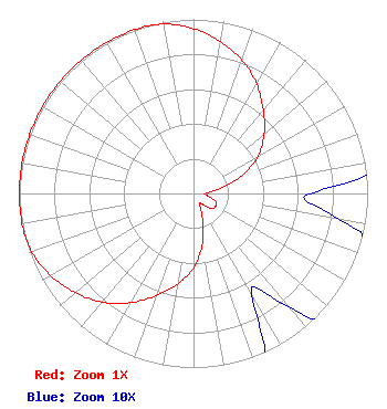 | ||||||||||||||||||
| Azimuth | Ratio | Azimuth | Ratio | Azimuth | Ratio | Azimuth | Ratio | ||||||||||||
| 0 | 0.946 | 10 | 0.886 | 20 | 0.815 | 30 | 0.725 | ||||||||||||
| 40 | 0.624 | 50 | 0.529 | 60 | 0.428 | 70 | 0.293 | ||||||||||||
| 80 | 0.146 | 90 | 0.067 | 100 | 0.085 | 110 | 0.136 | ||||||||||||
| 120 | 0.147 | 130 | 0.136 | 140 | 0.085 | 150 | 0.067 | ||||||||||||
| 160 | 0.146 | 170 | 0.293 | 180 | 0.428 | 190 | 0.529 | ||||||||||||
| 200 | 0.624 | 210 | 0.725 | 220 | 0.815 | 230 | 0.886 | ||||||||||||
| 240 | 0.946 | 250 | 0.988 | 260 | 1.000 | 270 | 1.000 | ||||||||||||
| 280 | 1.000 | 290 | 1.000 | 300 | 1.000 | 310 | 1.000 | ||||||||||||
| 320 | 1.000 | 330 | 1.000 | 340 | 1.000 | 350 | 0.988 | ||||||||||||
Structure Registration Number 1227740 Structure Type: TOWER Registered To: Wilson Broadcasting, Inc. Structure Address: 1210 Wagf Rd. Dothan, AL County Name: Houston County ASR Issued: 07/20/2001 Date Built: 04/01/2002 Site Elevation: 94.4 m (310 ft.) Structure Height: 150.7 m (494 ft.) Height Overall: 151.7 m (498 ft.) Overall Height AMSL: 246.1 m (807 ft.) FAA Determination: 05/31/2001 FAA Study #: 01-ASO-2016-OE FAA Circular #: 70/7460-1K Paint & Light FAA Chapters: 3, 4, 5, 12 SUPPLEMENTAL NOTICE STATES STRUCTURE REACHED GREATEST HEIGHT ON 11/30/2001 31-14-55.1 N 85-23-20.0 W (NAD 83) 31-14-54.5 N 85-23-20.2 W (Converted to NAD 27) |
Dothan, AL 44974 Phone: 334-671-1753 Individual | Title: Licensee Date: 09/22/2020 Application Certifier JAMES WILSON, III 4106 Ross Clark Circle Dothan, AL 44974 Applicant Dan J Alpert The Law Office Of Dan J. Alpert 2120 N. 21st Rd. Arlington, VA 22201 | |||||||||||||||||