
FCCInfo.com
A Service of Cavell, Mertz & Associates, Inc.
(855) FCC-INFO
|
|
KFGX-LD from 07/20/2010 KFGX-LD from 09/19/2007 KFGX-LD from 03/14/1991 |
|
|
||||||||||||||||
|
|
Status: License Application Accepted: 09/23/2020 License Expires: 04/01/2022 File Number: -0000122213 FCC Website Links: LMS Facility Details This Application Other KFGX-LD Applications Including Superseded Applications Mailing Address Correspondence for KFGX-LD Correspondence related to application -0000122213 Service Contour - Open Street Map or USGS Map (51 dBu) Service Contour - KML / Google Earth (51 dBu) Rabbit Ears Info Search for KFGX-LD Site Location: 46-51-23.8 N 96-44-26.4 W (NAD 83) Site Location: 46-51-23.9 N 96-44-25.1 W (Converted to NAD 27) ERP: 2 kW Polarization: Horizontally polarized R/C AGL: 29 m (95 ft.) R/C AMSL: 307.3 m (1008 ft.) Emission Mask: Full Service Site Elevation: 278.3 m. (913 ft.) Height Overall*: 96 m (315 ft.) (* As Filed In This Application, may differ from ASR Data, Below.) Directional Antenna - Antenna Make/Model: Scala PR-TV Antenna ID: 1007360 Polarization: Horizontally polarized | ||||||||||||||||||
| Antenna Data for Antenna Id: 1007360 KFGX-LD LD File: -0000122213 Scala - PR-TV Service: LD Standard Pattern: N Pattern and Field Values Include a 310° Clockwise Rotation | 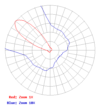 | ||||||||||||||||||
| Azimuth | Ratio | Azimuth | Ratio | Azimuth | Ratio | Azimuth | Ratio | ||||||||||||
| 0 | 0.059 | 10 | 0.052 | 20 | 0.049 | 30 | 0.049 | ||||||||||||
| 40 | 0.047 | 50 | 0.045 | 60 | 0.046 | 70 | 0.046 | ||||||||||||
| 80 | 0.040 | 90 | 0.038 | 100 | 0.030 | 110 | 0.028 | ||||||||||||
| 120 | 0.026 | 130 | 0.025 | 140 | 0.026 | 150 | 0.028 | ||||||||||||
| 160 | 0.030 | 170 | 0.038 | 180 | 0.040 | 190 | 0.046 | ||||||||||||
| 200 | 0.046 | 210 | 0.045 | 220 | 0.047 | 230 | 0.049 | ||||||||||||
| 240 | 0.049 | 250 | 0.052 | 260 | 0.059 | 270 | 0.090 | ||||||||||||
| 280 | 0.165 | 290 | 0.430 | 300 | 0.808 | 305 | 0.942 | ||||||||||||
| 310 | 1.000 | 315 | 0.942 | 320 | 0.808 | 330 | 0.430 | ||||||||||||
| 340 | 0.165 | 350 | 0.090 | ||||||||||||||||
Structure Registration Number 1059614 Structure Type: GTOWER Registered To: American Towers LLC Structure Address: 1774 25th St. South (moorhead #2 - 050679) Moorhead, MN County Name: Clay County ASR Issued: 10/18/2017 Date Built: 01/15/1998 Site Elevation: 278.3 m (913 ft.) Structure Height: 92.4 m (303 ft.) Height Overall: 96 m (315 ft.) Overall Height AMSL: 374.3 m (1228 ft.) FAA Determination: 10/17/2017 FAA Study #: 2017-AGL-17237-OE FAA Circular #: 70/7460-1L Paint & Light FAA Chapters: 4, 8, 12 PRIOR STUDY 2014-AGL-14531-OE 46-51-23.8 N 96-44-26.4 W (NAD 83) 46-51-23.9 N 96-44-25.1 W (Converted to NAD 27) |
Chattanooga, TN 37401 Phone: 423-468-5100 Limited Liability Company | Title: Coo Date: 09/23/2020 Application Certifier DIGITAL NETWORKS-MIDWEST, LLC Digital Networks-midwest, Llc Chattanooga, TN 37401 Applicant Jeremy D Ruck, PE Jeremy Ruck & Associates, Inc. Canton, IL 61520 Consulting Engineer Aaron P Shainis Shainis & Peltzman, Chartered 1850 M St. Nw Suite 240 Washington, DC 20036 FCC Legal Counsel | |||||||||||||||||