
FCCInfo.com
A Service of Cavell, Mertz & Associates, Inc.
(855) FCC-INFO
|
|
WQAW-LD from 07/09/2004 WQAW-LD from 06/13/2002 |
|
|
||||||||||||||||
|
|
Status: License Application Accepted: 09/28/2020 License Expires: 10/01/2020 File Number: -0000122659 FCC Website Links: LMS Facility Details This Application Other WQAW-LD Applications Including Superseded Applications Mailing Address Correspondence for WQAW-LD Correspondence related to application -0000122659 Service Contour - Open Street Map or USGS Map (51 dBu) Service Contour - KML / Google Earth (51 dBu) Rabbit Ears Info Search for WQAW-LD Site Location: 39-00-36.7 N 76-36-31.8 W (NAD 83) Site Location: 39-00-36.3 N 76-36-32.9 W (Converted to NAD 27) ERP: 6.5 kW Polarization: Horizontally polarized Electrical Beam Tilt: 0.5 degrees R/C AGL: 207 m (679 ft.) R/C AMSL: 251.5 m (825 ft.) Emission Mask: Stringent Site Elevation: 44.5 m. (146 ft.) Height Overall*: 275.2 m (903 ft.) (* As Filed In This Application, may differ from ASR Data, Below.) Directional Antenna - Antenna Make/Model: Propagation System Inc PSILP12AH-20 Antenna ID: Polarization: Horizontally polarized | ||||||||||||||||||
| Antenna Data for Antenna Id: WQAW-LD LD File: -0000122659 Propagation System Inc - PSILP12AH-20 Service: LD Standard Pattern: N Pattern and Field Values Include a 90° Clockwise Rotation | 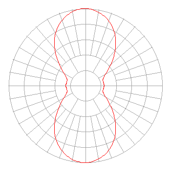 | ||||||||||||||||||
| Azimuth | Ratio | Azimuth | Ratio | Azimuth | Ratio | Azimuth | Ratio | ||||||||||||
| 0 | 1.000 | 10 | 0.967 | 20 | 0.889 | 30 | 0.764 | ||||||||||||
| 40 | 0.600 | 50 | 0.432 | 60 | 0.302 | 70 | 0.242 | ||||||||||||
| 80 | 0.237 | 90 | 0.242 | 100 | 0.237 | 110 | 0.242 | ||||||||||||
| 120 | 0.302 | 130 | 0.432 | 140 | 0.600 | 150 | 0.764 | ||||||||||||
| 160 | 0.889 | 170 | 0.967 | 180 | 1.000 | 190 | 0.974 | ||||||||||||
| 200 | 0.897 | 210 | 0.781 | 220 | 0.622 | 230 | 0.451 | ||||||||||||
| 240 | 0.324 | 250 | 0.258 | 260 | 0.248 | 270 | 0.256 | ||||||||||||
| 280 | 0.248 | 290 | 0.258 | 300 | 0.324 | 310 | 0.451 | ||||||||||||
| 320 | 0.622 | 330 | 0.781 | 340 | 0.897 | 350 | 0.974 | ||||||||||||
Structure Registration Number 1225569 Structure Type: GTOWER Registered To: Maryland Public Broadcasting Commission Structure Address: 1690 Hawkins Road Annapolis, MD County Name: Anne Arundel County ASR Issued: 02/28/2022 Date Built: 01/06/2021 Site Elevation: 44.5 m (146 ft.) Structure Height: 239.6 m (786 ft.) Height Overall: 275.2 m (903 ft.) Overall Height AMSL: 319.7 m (1049 ft.) FAA Determination: 11/25/2020 FAA Study #: 2020-AEA-12482-OE FAA Circular #: 70/7460-1M Paint & Light FAA Chapters: 4, 9, 15 PRIOR STUDY 2002-AEA-4009-OE 39-00-36.7 N 76-36-31.8 W (NAD 83) 39-00-36.3 N 76-36-32.9 W (Converted to NAD 27) |
295 Madison Avenue, 12th Floor New York, NY 10017 Phone: 954-606-5486 Corporation | Title: Chief Operating Officer Date: 09/28/2020 Application Certifier Hc2 Station Group, Inc. 450 Park Avenue 30th Floor New York, NY 10022 Applicant REBECCA HANSON Hc2 Station Group, Inc. 450 Park Avenue 30th Floor New York, NY 10022 EVP and General Counsel RENEE ILHARDT Hc2 Station Group, Inc. 450 Park Avenue 30th Floor New York, NY 10022 | |||||||||||||||||