
FCCInfo.com
A Service of Cavell, Mertz & Associates, Inc.
(855) FCC-INFO
|
|
W32EI-D from 11/07/2012 W32EI-D from 02/25/2004 |
|
|
||||||||||||||||
|
|
W32EI-D is a channel sharing guest of W33ET-D, New York, New York Status: STA – Special Temporary Authority Application Accepted: 09/29/2020 STA Expires: 03/23/2021 File Number: -0000122949 FCC Website Links: LMS Facility Details This Application Other W32EI-D Applications Including Superseded Applications Mailing Address Correspondence for W32EI-D Correspondence related to application -0000122949 Service Contour - Open Street Map or USGS Map (51 dBu) Service Contour - KML / Google Earth (51 dBu) Rabbit Ears Info Search for W32EI-D Site Location: 41-00-35.6 N 74-35-37.4 W (NAD 83) Site Location: 41-00-35.2 N 74-35-38.8 W (Converted to NAD 27) ERP: 1.87 kW Polarization: Horizontally polarized R/C AGL: 65.5 m (215 ft.) R/C AMSL: 471.5 m (1547 ft.) Emission Mask: Full Service Site Elevation: 406 m. (1332 ft.) Height Overall*: 85.6 m (281 ft.) (* As Filed In This Application, may differ from ASR Data, Below.) Directional Antenna - Antenna Make/Model: MICRO COMMUNICATIONS INC 955318 Antenna ID: 20061 Polarization: Horizontally polarized | ||||||||||||||||||
| Antenna Data for Antenna Id: 20061 W32EI-D LD File: -0000122949 MICRO COMMUNICATIONS INC - 955318 Service: LD Standard Pattern: Y Pattern and Field Values Include a 11° Clockwise Rotation | 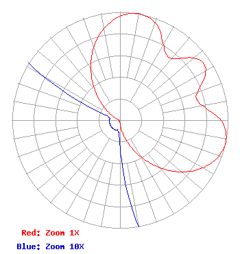 | ||||||||||||||||||
| Azimuth | Ratio | Azimuth | Ratio | Azimuth | Ratio | Azimuth | Ratio | ||||||||||||
| 1 | 0.967 | 11 | 1.000 | 21 | 0.947 | 31 | 0.793 | ||||||||||||
| 36 | 0.740 | 41 | 0.756 | 51 | 0.902 | 56 | 0.933 | ||||||||||||
| 61 | 0.902 | 71 | 0.756 | 76 | 0.740 | 81 | 0.793 | ||||||||||||
| 91 | 0.947 | 101 | 1.000 | 111 | 0.967 | 121 | 0.872 | ||||||||||||
| 131 | 0.729 | 141 | 0.556 | 151 | 0.378 | 161 | 0.218 | ||||||||||||
| 171 | 0.094 | 181 | 0.021 | 191 | 0.010 | 201 | 0.010 | ||||||||||||
| 211 | 0.010 | 221 | 0.010 | 231 | 0.010 | 241 | 0.010 | ||||||||||||
| 251 | 0.010 | 261 | 0.010 | 271 | 0.010 | 281 | 0.010 | ||||||||||||
| 291 | 0.021 | 301 | 0.094 | 311 | 0.218 | 321 | 0.378 | ||||||||||||
| 331 | 0.556 | 341 | 0.729 | 351 | 0.872 | ||||||||||||||
Structure Registration Number 1032928 Structure Type: LTOWER Registered To: American Towers LLC Structure Address: Weldon Road (092873 / Mci Sparta Nj) Sparta, NJ County Name: Sussex County ASR Issued: 01/18/2016 Date Built: 06/09/2009 Site Elevation: 406 m (1332 ft.) Structure Height: 83.8 m (275 ft.) Height Overall: 85.6 m (281 ft.) Overall Height AMSL: 491.6 m (1613 ft.) FAA Determination: 03/10/2015 FAA Study #: 2015-AEA-583-OE FAA Circular #: 70/7460-1K Paint & Light FAA Chapters: 4, 6, 12 PRIOR STUDY 2013-AEA-1556-OE 41-00-35.6 N 74-35-37.4 W (NAD 83) 41-00-35.2 N 74-35-38.8 W (Converted to NAD 27) |
2383 Pruneridge Avenue Suite 4 Santa Clara, CA 95050 Phone: 415-886-7284 Corporation | Title: Manager Date: 09/29/2020 Application Certifier Venture Technologies Group, Llc 5670 Wilshire Blvd., Suite 1620 Los Angeles, CA 90036 Applicant LAWRENCE ROGOW Venture Technologies Group, Llc 5670 Wilshire , Suite 1620 Los Angeles, CA 90036 JOAN STEWART Wiley Rein Llp 1776 K Street Nw Washington, DC 20006 | |||||||||||||||||