
FCCInfo.com
A Service of Cavell, Mertz & Associates, Inc.
(855) FCC-INFO
|
|
|
|
|
||||||||||||||||
|
|
Status: License Application Accepted: 10/01/2020 License Expires: 04/01/2022 File Number: -0000123670 FCC Website Links: LMS Facility Details This Application Other K23MF-D Applications Including Superseded Applications Mailing Address Correspondence for K23MF-D Correspondence related to application -0000123670 Service Contour - Open Street Map or USGS Map (51 dBu) Service Contour - KML / Google Earth (51 dBu) Rabbit Ears Info Search for K23MF-D Site Location: 44-06-28.0 N 94-35-56.0 W (NAD 83) Site Location: 44-06-28.1 N 94-35-55.1 W (Converted to NAD 27) ERP: 1.8 kW Polarization: Horizontally polarized R/C AGL: 181 m (594 ft.) R/C AMSL: 495.6 m (1626 ft.) Emission Mask: Stringent Site Elevation: 314.6 m. (1032 ft.) Height Overall*: 186.5 m (612 ft.) (* As Filed In This Application, may differ from ASR Data, Below.) Directional Antenna - Antenna Make/Model: MICRO COMMUNICATIONS INC 955116 Antenna ID: 20051 Polarization: Horizontally polarized
| ||||||||||||||||||
| Antenna Data for Antenna Id: 20051 K23MF-D LD File: -0000123670 MICRO COMMUNICATIONS INC - 955116 Service: LD Standard Pattern: Y | 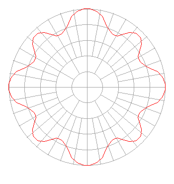 | ||||||||||||||||||
| Azimuth | Ratio | Azimuth | Ratio | Azimuth | Ratio | Azimuth | Ratio | ||||||||||||
| 0 | 1.000 | 10 | 0.947 | 20 | 0.793 | 30 | 0.756 | ||||||||||||
| 40 | 0.902 | 45 | 0.933 | 50 | 0.902 | 60 | 0.756 | ||||||||||||
| 70 | 0.793 | 80 | 0.947 | 90 | 1.000 | 100 | 0.947 | ||||||||||||
| 110 | 0.793 | 120 | 0.756 | 130 | 0.902 | 135 | 0.933 | ||||||||||||
| 140 | 0.902 | 150 | 0.756 | 160 | 0.793 | 170 | 0.947 | ||||||||||||
| 180 | 1.000 | 190 | 0.947 | 200 | 0.793 | 210 | 0.756 | ||||||||||||
| 220 | 0.902 | 225 | 0.933 | 230 | 0.902 | 240 | 0.756 | ||||||||||||
| 250 | 0.793 | 260 | 0.947 | 270 | 1.000 | 280 | 0.947 | ||||||||||||
| 290 | 0.793 | 300 | 0.756 | 310 | 0.902 | 315 | 0.933 | ||||||||||||
| 320 | 0.902 | 330 | 0.756 | 340 | 0.793 | 350 | 0.947 | ||||||||||||
Structure Registration Number 1024448 Structure Type: 2TOWER Registered To: COOPERATIVE TELEVISION OF SOUTHERN MINNESOTA DBA = BROWN COUNTY RURAL ELECTRIC ASSOCIATION Structure Address: 3.2 Km E Godahl, MN County Name: Watonwan County ASR Issued: 07/28/1997 Date Built: 01/01/1980 Site Elevation: 314.6 m (1032 ft.) Structure Height: 186.5 m (612 ft.) Height Overall: 186.5 m (612 ft.) Overall Height AMSL: 501.1 m (1644 ft.) FAA Determination: 09/24/1980 FAA Study #: 80-GL-1233-OE Paint & Light FAA Chapters: 1, 3, 5, 14, 21 RED LIGHTS/PAINT 44-06-28.0 N 94-35-56.0 W (NAD 83) 44-06-28.1 N 94-35-55.1 W (Converted to NAD 27) |
P.o. Box 8 Mankato, MN 56002 Phone: 507-387-7963 Applicant | Title: Manager Date: 10/01/2020 Application Certifier COOPERATIVE TELEVISION ASSOCIATION OF SOUTHERN MINNESOTA Cooperative Television Association Of Southern Minnesota P.o. Box 8 Mankato, MN 56002 Applicant Thomas Uppman Uppman Technical Services. 2230 Bentz Court Chanhassen, MN 55317 Shelley Sadowsky, Esq Shelley Sadowsky, Llc 5938 Dorchester Way Rockville, MD 20852 Darryl K DeLawder Delawder Communications, Inc. P.o Box 1095 Ashburn, VA 20146 President Tom Uppman Uppman Technical Services 27408 Scenic Byway Road Belle Plaine, MN 56011 TECHNICAL CONSULTANT | |||||||||||||||||
| |||||||||||||||||||