
FCCInfo.com
A Service of Cavell, Mertz & Associates, Inc.
(855) FCC-INFO
|
|
|
Virtual Channel 52 |  |
|
|||||||||||||||
|
|
Repacking Information: No changes Status: License Application Accepted: 10/07/2020 License Expires: 08/01/2022 File Number: -0000124274 FCC Website Links: LMS Facility Details This Application Other KFWD Applications Including Superseded Applications Mailing Address Correspondence for KFWD Correspondence related to application -0000124274 Service Contour - Open Street Map or USGS Map (36 dBu) Service Contour - KML / Google Earth (36 dBu) Public Inspection Files Rabbit Ears Info Search for KFWD Site Location: 32-35-20.0 N 96-58-05.9 W (NAD 83) Site Location: 32-35-19.5 N 96-58-04.9 W (Converted to NAD 27) ERP: 26 kW Polarization: Horizontally polarized HAAT: 546 m (1791 ft.) Electrical Beam Tilt: 1.5 degrees R/C AGL: 493 m (1617 ft.) R/C AMSL: 736.8 m (2417 ft.) Site Elevation: 243.8 m. (800 ft.) Height Overall*: 506.2 m (1661 ft.) (* As Filed In This Application, may differ from ASR Data, Below.) Directional Antenna - Antenna Make/Model: DIELECTRIC THV-6A9-R C180 Antenna ID: 85241 Polarization: Horizontally polarized | ||||||||||||||||||
| Antenna Data for Antenna Id: 85241 KFWD DT File: -0000124274 DIELECTRIC - THV-6A9-R C180 Service: DT Standard Pattern: Y | 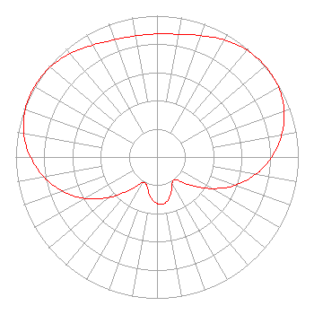 | ||||||||||||||||||
| Azimuth | Ratio | Azimuth | Ratio | Azimuth | Ratio | Azimuth | Ratio | ||||||||||||
| 0 | 0.871 | 10 | 0.882 | 20 | 0.914 | 30 | 0.957 | ||||||||||||
| 40 | 0.988 | 50 | 1.000 | 60 | 0.991 | 70 | 0.958 | ||||||||||||
| 80 | 0.895 | 90 | 0.812 | 100 | 0.709 | 110 | 0.587 | ||||||||||||
| 120 | 0.446 | 130 | 0.309 | 140 | 0.209 | 150 | 0.214 | ||||||||||||
| 160 | 0.281 | 170 | 0.330 | 180 | 0.330 | 190 | 0.281 | ||||||||||||
| 200 | 0.214 | 210 | 0.209 | 220 | 0.309 | 230 | 0.446 | ||||||||||||
| 240 | 0.587 | 250 | 0.709 | 260 | 0.812 | 270 | 0.895 | ||||||||||||
| 280 | 0.958 | 290 | 0.991 | 300 | 1.000 | 310 | 0.988 | ||||||||||||
| 320 | 0.957 | 330 | 0.914 | 340 | 0.882 | 350 | 0.871 | ||||||||||||
Structure Registration Number 1045531 Structure Type: GTOWER Registered To: American Towers LLC Structure Address: 1310 West Beltline Road (cowboy Tower/dallas #75256) Cedar Hill, TX County Name: Dallas County ASR Issued: 09/20/2023 Date Built: 09/19/2008 Site Elevation: 243.8 m (800 ft.) Structure Height: 480.7 m (1577 ft.) Height Overall: 506.2 m (1661 ft.) Overall Height AMSL: 750 m (2461 ft.) FAA Determination: 04/10/2023 FAA Study #: 2022-ASW-23640-OE FAA Circular #: 70/7460-1M Paint & Light FAA Chapters: 4, 9, 15 PRIOR STUDY 2005-ASW-25-OE 32-35-20.0 N 96-58-05.9 W (NAD 83) 32-35-19.5 N 96-58-04.9 W (Converted to NAD 27) |
800 Westchester Ave. Suite S-640 Rye Brook, NY 10573 Phone: 914-417-2700 Limited Liability Company | Title: Chief Operating Officer Date: 10/07/2020 Application Certifier Rnn National, Llc 800 Westchester Ave. Suite S-640 Rye Brook, NY 10573 Applicant Ari Meltzer, Esq Wiley Rein Llp 1776 K Street, N.w. Washington, DC 20006 | |||||||||||||||||