
FCCInfo.com
A Service of Cavell, Mertz & Associates, Inc.
(855) FCC-INFO
|
|
KHSV from 11/04/2014 KHSV from 07/09/2010 KHSV from 06/23/2009 |
Virtual Channel 21 |  |
|
|||||||||||||||||||||||||||||||||||||||
|
|
Repacking Information: No changes Status: Application Application Accepted: 11/27/2020 License Expires: 10/01/2022 File Number: -0000127675 FCC Website Links: LMS Facility Details This Application Other KHSV Applications Including Superseded Applications Mailing Address Correspondence for KHSV Correspondence related to application -0000127675 Service Contour - Open Street Map or USGS Map (41 dBu) Service Contour - KML / Google Earth (41 dBu) Public Inspection Files History Cards for KHSV Rabbit Ears Info Search for KHSV Site Location: 36-00-31.0 N 115-00-20.0 W (NAD 83) Site Location: 36-00-31.1 N 115-00-17.0 W (Converted to NAD 27) ERP: 1000 kW Polarization: Elliptically polarized HAAT: 386 m (1266 ft.) Electrical Beam Tilt: 0.75 degrees R/C AGL: 69 m (226 ft.) R/C AMSL: 1080 m (3543 ft.) Site Elevation: 1011 m. (3317 ft.) Height Overall*: 83.2 m (273 ft.) (* As Filed In This Application, may differ from ASR Data, Below.) Directional Antenna - Antenna Make/Model: Dielectric TFU-25ETT/VP-R 4C150 Antenna ID: 1007633 Polarization: Elliptically polarized
| ||||||||||||||||||||||||||||||||||||||||||
| Antenna Data for Antenna Id: 1007633 KHSV DT File: -0000127675 Dielectric - TFU-25ETT/VP-R 4C150 Service: DT Standard Pattern: N | 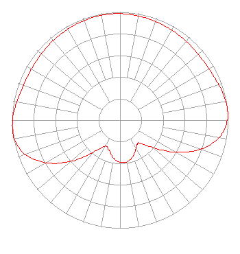 | ||||||||||||||||||||||||||||||||||||||||||
| Azimuth | Ratio | Azimuth | Ratio | Azimuth | Ratio | Azimuth | Ratio | ||||||||||||||||||||||||||||||||||||
| 0 | 0.985 | 10 | 0.979 | 20 | 0.970 | 30 | 0.961 | ||||||||||||||||||||||||||||||||||||
| 40 | 0.952 | 50 | 0.946 | 60 | 0.950 | 70 | 0.970 | ||||||||||||||||||||||||||||||||||||
| 80 | 0.995 | 85 | 1.000 | 90 | 0.994 | 100 | 0.931 | ||||||||||||||||||||||||||||||||||||
| 110 | 0.790 | 120 | 0.592 | 130 | 0.391 | 140 | 0.278 | ||||||||||||||||||||||||||||||||||||
| 143 | 0.272 | 150 | 0.297 | 160 | 0.355 | 170 | 0.389 | ||||||||||||||||||||||||||||||||||||
| 175 | 0.394 | 180 | 0.389 | 190 | 0.355 | 200 | 0.297 | ||||||||||||||||||||||||||||||||||||
| 210 | 0.278 | 220 | 0.391 | 230 | 0.592 | 240 | 0.790 | ||||||||||||||||||||||||||||||||||||
| 250 | 0.931 | 260 | 0.994 | 270 | 0.995 | 280 | 0.970 | ||||||||||||||||||||||||||||||||||||
| 290 | 0.950 | 300 | 0.946 | 310 | 0.952 | 320 | 0.961 | ||||||||||||||||||||||||||||||||||||
| 330 | 0.970 | 340 | 0.979 | 350 | 0.985 | ||||||||||||||||||||||||||||||||||||||
Structure Registration Number 1234294 Structure Type: TOWER Registered To: VALLEY BROADCASTING CO. Structure Address: 2.2 Miles West Of Henderson, Nv, On Black Mountain Henderson, NV County Name: Clark County ASR Issued: 10/21/2003 Date Built: 05/31/2003 Site Elevation: 1011 m (3317 ft.) Structure Height: 50.3 m (165 ft.) Height Overall: 83.2 m (273 ft.) Overall Height AMSL: 1094.2 m (3590 ft.) FAA Determination: 05/22/2002 FAA Study #: 02-AWP-1284-OE FAA Circular #: 70/7460-1K Paint & Light FAA Chapters: 4, 8, 12 36-00-31.0 N 115-00-20.0 W (NAD 83) 36-00-31.1 N 115-00-17.0 W (Converted to NAD 27) |
201 Massachusetts Avenue Ne Suite C-1 Washington, DC 20002 Phone: 202-546-5400 Corporation | Title: Manager Of Hsh Date: 11/27/2020 Application Certifier Channel 33, Inc. Washington, DC 20003 Applicant John E. Hidle, PE Carl T. Jones Corporation 7901 Yarnwood Court Springfield, VA 22153-2827 Consulting Engineer Colby M May, Esq. Colby M. May, Esq., P.c Wash, DC 22003 FCC Counsel | |||||||||||||||||||||||||||||||||||||||||
|
| ||||||||||||||||||||||||||||||||||||||||||