
FCCInfo.com
A Service of Cavell, Mertz & Associates, Inc.
(855) FCC-INFO
|
|
K31NW-D from 09/28/2010 |
|
|
||||||||||||||||
|
|
Status: License Application Accepted: 10/22/2020 License Expires: 04/01/2022 File Number: -0000124962 FCC Website Links: LMS Facility Details This Application Other K31NW-D Applications Including Superseded Applications Mailing Address Correspondence for K31NW-D Correspondence related to application -0000124962 Service Contour - Open Street Map or USGS Map (51 dBu) Service Contour - KML / Google Earth (51 dBu) Rabbit Ears Info Search for K31NW-D Site Location: 46-15-39.5 N 106-40-23.2 W (NAD 83) Site Location: 46-15-39.5 N 106-40-21.1 W (Converted to NAD 27) ERP: 0.1 kW Polarization: Horizontally polarized R/C AGL: 11 m (36 ft.) R/C AMSL: 870.8 m (2857 ft.) Emission Mask: Simple Site Elevation: 859.8 m. (2821 ft.) Height Overall*: 12.4 m (41 ft.) (* As Filed In This Application, may differ from ASR Data, Below.) Directional Antenna - Antenna Make/Model: Scala 1X2KBBU Antenna ID: 20718 Polarization: Horizontally polarized
| ||||||||||||||||||
| Antenna Data for Antenna Id: 20718 K31NW-D LD File: -0000124962 Scala - 1X2KBBU Service: LD Standard Pattern: Y | 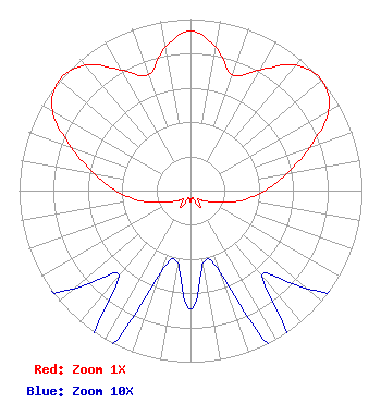 | ||||||||||||||||||
| Azimuth | Ratio | Azimuth | Ratio | Azimuth | Ratio | Azimuth | Ratio | ||||||||||||
| 0 | 0.931 | 10 | 0.846 | 20 | 0.717 | 30 | 0.813 | ||||||||||||
| 40 | 0.955 | 50 | 1.000 | 60 | 0.931 | 70 | 0.738 | ||||||||||||
| 80 | 0.570 | 90 | 0.432 | 100 | 0.316 | 110 | 0.202 | ||||||||||||
| 120 | 0.131 | 130 | 0.089 | 140 | 0.065 | 150 | 0.116 | ||||||||||||
| 160 | 0.051 | 170 | 0.043 | 180 | 0.069 | 190 | 0.043 | ||||||||||||
| 200 | 0.051 | 210 | 0.116 | 220 | 0.065 | 230 | 0.089 | ||||||||||||
| 240 | 0.131 | 250 | 0.202 | 260 | 0.316 | 270 | 0.432 | ||||||||||||
| 280 | 0.570 | 290 | 0.738 | 300 | 0.931 | 310 | 1.000 | ||||||||||||
| 320 | 0.955 | 330 | 0.813 | 340 | 0.717 | 350 | 0.846 | ||||||||||||
Structure Registration Number 1237131 Structure Type: TOWER Registered To: Forsyth T.V. Tax District Structure Address: 0.5 Miles South Of Forsyth Forsyth, MT County Name: Rosebud County ASR Issued: 12/19/2002 Site Elevation: 859.8 m (2821 ft.) Structure Height: 12.4 m (41 ft.) Height Overall: 12.4 m (41 ft.) Overall Height AMSL: 872.2 m (2862 ft.) FAA Determination: 10/16/2002 FAA Study #: 2002-ANM-1809-OE FAA Circular #: Paint & Light FAA Chapters: NONE Removed expiration date from determination. Scenario 1./jjs/case#635066 46-15-39.5 N 106-40-23.2 W (NAD 83) 46-15-39.5 N 106-40-21.1 W (Converted to NAD 27) |
Rosebud County Courthouse Po Box 47 Forsyth, MT 59327 Phone: 406-346-2251 Government Entity | Title: Commissioner Date: 10/22/2020 Application Certifier FORSYTH COMMUNITY TV RELAY SYSTEM Forsyth Community Tv Relay System Rosebud County Courthouse Po Box 47 Forsyth, MT 59327 Applicant Charlie Cannaliato Canyon Tv 200 Evans Ave. Missoula, MT 59801 ENGINEERING CONSULTANT Paul Grutkowski East-mont Communications 1819 Main St., Suite A Miles City, MT 59301 | |||||||||||||||||