
FCCInfo.com
A Service of Cavell, Mertz & Associates, Inc.
(855) FCC-INFO
|
|
KNPL-LD from 08/20/2009 KNPL-LD from 12/17/1982 |
|
|
|||||||||||||||||
|
|
Status: License (Licensed And Silent) Application Accepted: 10/29/2020 License Expires: 06/01/2022 File Number: -0000125163 FCC Website Links: LMS Facility Details This Application Other KNPL-LD Applications Including Superseded Applications Mailing Address Correspondence for KNPL-LD Correspondence related to application -0000125163 Service Contour - Open Street Map or USGS Map (51 dBu) Service Contour - KML / Google Earth (51 dBu) Rabbit Ears Info Search for KNPL-LD Site Location: 41-12-13.0 N 100-44-00.0 W (NAD 83) Site Location: 41-12-13.0 N 100-43-58.5 W (Converted to NAD 27) ERP: 9.5 kW Polarization: Horizontally polarized Electrical Beam Tilt: 1.75 degrees R/C AGL: 76.2 m (250 ft.) R/C AMSL: 996 m (3268 ft.) Emission Mask: Full Service Site Elevation: 919.8 m. (3018 ft.) Height Overall*: 185.6 m (609 ft.) (* As Filed In This Application, may differ from ASR Data, Below.) Directional Antenna - Antenna Make/Model: Scala SL-8 Antenna ID: 23503 Polarization: Horizontally polarized
| |||||||||||||||||||
| Antenna Data for Antenna Id: 23503 KNPL-LD LD File: -0000125163 Scala - SL-8 Service: LD Standard Pattern: Y Pattern and Field Values Include a 200° Clockwise Rotation | 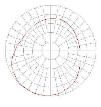 | |||||||||||||||||||
| Azimuth | Ratio | Azimuth | Ratio | Azimuth | Ratio | Azimuth | Ratio | |||||||||||||
| 0 | 0.700 | 10 | 0.710 | 20 | 0.720 | 30 | 0.700 | |||||||||||||
| 40 | 0.690 | 50 | 0.670 | 60 | 0.650 | 70 | 0.640 | |||||||||||||
| 80 | 0.640 | 90 | 0.650 | 100 | 0.660 | 110 | 0.690 | |||||||||||||
| 120 | 0.740 | 130 | 0.790 | 140 | 0.850 | 150 | 0.890 | |||||||||||||
| 160 | 0.930 | 170 | 0.960 | 180 | 0.980 | 190 | 0.990 | |||||||||||||
| 200 | 1.000 | 210 | 0.990 | 220 | 0.990 | 230 | 0.970 | |||||||||||||
| 240 | 0.940 | 250 | 0.910 | 260 | 0.850 | 270 | 0.780 | |||||||||||||
| 280 | 0.730 | 290 | 0.680 | 300 | 0.660 | 310 | 0.650 | |||||||||||||
| 320 | 0.650 | 330 | 0.660 | 340 | 0.680 | 350 | 0.690 | |||||||||||||
Structure Registration Number 1048076 Structure Type: TOWER Registered To: Gray Media Group, Inc. Structure Address: 4.7 Miles Northeast Of Center North Platte, NE County Name: Lincoln County ASR Issued: 09/09/2020 Date Built: 01/01/1940 Site Elevation: 919.8 m (3018 ft.) Structure Height: 185.6 m (609 ft.) Height Overall: 185.6 m (609 ft.) Overall Height AMSL: 1105.4 m (3627 ft.) Paint & Light FAA Chapters: 1, 3, 5, 14, 21 41-12-13.0 N 100-44-00.0 W (NAD 83) 41-12-13.0 N 100-43-58.5 W (Converted to NAD 27) |
4370 Peachtree Road, Ne Atlanta, GA 30319 Phone: 404-504-9828 Limited Liability Company | Title: Assistant Secretary Date: 10/29/2020 Application Certifier Gray Television Licensee, Llc 840 North 40th Street Lincoln, NE 68503 Applicant Joseph M. Davis, P.E. Chesapeake Rf Consultants, Llc 207 Old Dominion Road Yorktown, VA 23692 Consulting Engineer JOAN STEWART Wiley Rein Llp 1776 K Street Nw Washington, DC 20006 | ||||||||||||||||||