
FCCInfo.com
A Service of Cavell, Mertz & Associates, Inc.
(855) FCC-INFO
|
|
WYCI from 02/16/2006 |
Post-repack Channel 34 Virtual Channel 40 |
|
||||||||||||||||
|
|
Repacking Information: Pre-Repack Channel: 40 Post-Repack Channel: 34 Post-Repack ERP: 6.94 kW Phase: 0 Completion Deadline: 9/1/2018 Find nearby TV Facilities Status: Construction Permit Application Accepted: 11/27/2020 WYCI CP Expires: 08/11/2025 File Number: -0000127536 FCC Website Links: LMS Facility Details This Application Other WYCI Applications Including Superseded Applications Mailing Address Correspondence for WYCI Correspondence related to application -0000127536 Service Contour - Open Street Map or USGS Map (41 dBu) Service Contour - KML / Google Earth (41 dBu) Public Inspection Files Rabbit Ears Info Search for WYCI DTS Site Number: 1 Site Location: 44-34-27.3 N 73-40-29.0 W (NAD 83) Site Location: 44-34-27.1 N 73-40-30.5 W (Converted to NAD 27) ERP: 200 kW Polarization: Elliptically polarized HAAT: 529.3 m (1737 ft.) Electrical Beam Tilt: 1.0 degree R/C AGL: 225 m (738 ft.) R/C AMSL: 836.7 m (2745 ft.) Site Elevation: 611.7 m. (2007 ft.) Height Overall*: 233 m (764 ft.) (* As Filed In This Application, may differ from ASR Data, Below.) Directional Antenna - Antenna Make/Model: Dielectric TFU-16DSB-B/VP-R Antenna ID: 1007609 Polarization: Elliptically polarized | ||||||||||||||||||
| Antenna Data for Antenna Id: 1007609 WYCI DD File: -0000127536 Dielectric - TFU-16DSB-B/VP-R Service: DD Standard Pattern: N Pattern and Field Values Include a 90° Clockwise Rotation | 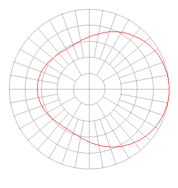 | ||||||||||||||||||
| Azimuth | Ratio | Azimuth | Ratio | Azimuth | Ratio | Azimuth | Ratio | ||||||||||||
| 0 | 0.650 | 10 | 0.699 | 20 | 0.759 | 30 | 0.817 | ||||||||||||
| 40 | 0.869 | 50 | 0.914 | 60 | 0.951 | 70 | 0.975 | ||||||||||||
| 80 | 0.993 | 90 | 1.000 | 100 | 0.996 | 110 | 0.981 | ||||||||||||
| 120 | 0.955 | 130 | 0.920 | 140 | 0.876 | 150 | 0.826 | ||||||||||||
| 160 | 0.771 | 170 | 0.714 | 180 | 0.661 | 190 | 0.615 | ||||||||||||
| 200 | 0.583 | 210 | 0.569 | 220 | 0.571 | 230 | 0.586 | ||||||||||||
| 240 | 0.607 | 250 | 0.627 | 260 | 0.640 | 270 | 0.645 | ||||||||||||
| 280 | 0.641 | 290 | 0.631 | 300 | 0.613 | 310 | 0.592 | ||||||||||||
| 320 | 0.579 | 330 | 0.570 | 340 | 0.579 | 350 | 0.610 | ||||||||||||
Structure Registration Number 1003384 Structure Type: GTOWER Registered To: County of Essex Structure Address: Terry Mtn 7.3 Mi W Peru, NY County Name: Clinton County ASR Issued: 12/05/2023 Date Built: 09/09/2016 Site Elevation: 611.7 m (2007 ft.) Structure Height: 233 m (764 ft.) Height Overall: 233.2 m (765 ft.) Overall Height AMSL: 844.9 m (2772 ft.) FAA Determination: 12/04/2023 FAA Study #: 2023-AEA-14508-OE FAA Circular #: 70/7460-1M Paint & Light FAA Chapters: 4, 9, 15 PRIOR STUDY 2015-AEA-2856-OE 44-34-27.3 N 73-40-29.0 W (NAD 83) 44-34-27.1 N 73-40-30.5 W (Converted to NAD 27) |
4370 Peachtree Road, Ne Atlanta, GA 30319 Phone: 404-504-9828 Limited Liability Company | Title: Assistant Secretary Date: 11/27/2020 Application Certifier GRAY TELEVISION LICENSEE, LLC Gray Television Licensee, Llc 4370 Peachtree Road, Ne Atlanta, GA 30319 Applicant David Burke Gray Television Licensee, Llc 201 Monroe Street Montgomery, AL 36104 Senior Vice President and CTO Joan Steward, Esq. Wiley Rein Llp 1776 K Street Nw Washington, DC 20006 | |||||||||||||||||