
FCCInfo.com
A Service of Cavell, Mertz & Associates, Inc.
(855) FCC-INFO
|
|
KGNG-LD from 01/12/2007 |
|
|
||||||||||||||||
|
|
Status: License Application Accepted: 11/20/2020 License Expires: 10/03/2022 File Number: -0000126700 FCC Website Links: LMS Facility Details This Application Other KGNG-LD Applications Including Superseded Applications Mailing Address Correspondence for KGNG-LD Correspondence related to application -0000126700 Service Contour - Open Street Map or USGS Map (51 dBu) Service Contour - KML / Google Earth (51 dBu) Rabbit Ears Info Search for KGNG-LD Site Location: 35-56-46.0 N 115-02-37.0 W (NAD 83) Site Location: 35-56-46.1 N 115-02-34.0 W (Converted to NAD 27) ERP: 15 kW Polarization: Horizontally polarized R/C AGL: 15.2 m (50 ft.) R/C AMSL: 1331.9 m (4370 ft.) Emission Mask: Stringent Site Elevation: 1316.7 m. (4320 ft.) Height Overall*: 83.5 m (274 ft.) (* As Filed In This Application, may differ from ASR Data, Below.) Directional Antenna - Antenna Make/Model: Scala 4X3KBBU Antenna ID: 20757 Polarization: Horizontally polarized | ||||||||||||||||||
| Antenna Data for Antenna Id: 20757 KGNG-LD LD File: -0000126700 Scala - 4X3KBBU Service: LD Standard Pattern: Y Pattern and Field Values Include a 315° Clockwise Rotation | 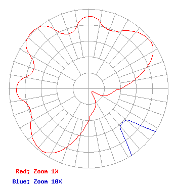 | ||||||||||||||||||
| Azimuth | Ratio | Azimuth | Ratio | Azimuth | Ratio | Azimuth | Ratio | ||||||||||||
| 5 | 0.897 | 15 | 0.791 | 25 | 0.792 | 35 | 0.886 | ||||||||||||
| 45 | 0.957 | 55 | 0.973 | 65 | 0.873 | 75 | 0.674 | ||||||||||||
| 85 | 0.486 | 95 | 0.338 | 105 | 0.277 | 115 | 0.212 | ||||||||||||
| 125 | 0.082 | 135 | 0.061 | 145 | 0.082 | 155 | 0.212 | ||||||||||||
| 165 | 0.277 | 175 | 0.338 | 185 | 0.486 | 195 | 0.674 | ||||||||||||
| 205 | 0.873 | 215 | 0.973 | 225 | 0.957 | 235 | 0.886 | ||||||||||||
| 245 | 0.792 | 255 | 0.791 | 265 | 0.897 | 275 | 0.880 | ||||||||||||
| 285 | 0.740 | 295 | 0.757 | 305 | 0.958 | 315 | 1.000 | ||||||||||||
| 325 | 0.958 | 335 | 0.757 | 345 | 0.740 | 355 | 0.880 | ||||||||||||
Structure Registration Number 1020486 Structure Type: TOWER Registered To: KUPN Licensee, LLC Structure Address: 7-a Black Mountain Rd Black Mtn Arden Site Henderson, NV County Name: Clark County ASR Issued: 01/11/2017 Date Built: 03/01/1989 Site Elevation: 1316.7 m (4320 ft.) Structure Height: 81.4 m (267 ft.) Height Overall: 83.5 m (274 ft.) Overall Height AMSL: 1400.2 m (4594 ft.) FAA Determination: 04/18/1997 FAA Study #: 97-AWP-0697-OE Paint & Light FAA Chapters: NONE ADJACENT TO EXISTING STRUCTURES WHICH ARE MARKED & LIGHTED. LCS 35-56-46.0 N 115-02-37.0 W (NAD 83) 35-56-46.1 N 115-02-34.0 W (Converted to NAD 27) |
452 E. Silverado Ranch Blvd. #471 Las Vegas, NV 89183 Phone: 702-642-8847 Corporation | Title: President Date: 11/20/2020 Application Certifier KING KONG BROADCASTING, INC. King Kong Broadcasting, Inc. 452 E. Silverado Ranch Blvd. #471 Las Vegas, NV 89183 Applicant Susan Hansen B. W. St. Clair 6868 Vivian St. Arvada, CO 80004 CONSULTANT LARRY Hunt King Kong Broadcasting, Inc. 452 E. Silerado Ranch Blvd., #471 Las Vegas, NV 89183 | |||||||||||||||||