
FCCInfo.com
A Service of Cavell, Mertz & Associates, Inc.
(855) FCC-INFO
|
|
KWWT from 07/01/1998 KWWT from 06/01/1998 |
Virtual Channel 30 |
|
||||||||||||||||
|
|
Repacking Information: No changes Status: Construction Permit Application Accepted: 11/27/2020 KWWT CP Expires: 08/24/2023 File Number: -0000127640 FCC Website Links: LMS Facility Details This Application Other KWWT Applications Including Superseded Applications Mailing Address Correspondence for KWWT Correspondence related to application -0000127640 Service Contour - Open Street Map or USGS Map (41 dBu) Service Contour - KML / Google Earth (41 dBu) Public Inspection Files Rabbit Ears Info Search for KWWT Site Location: 31-51-50.8 N 102-34-42.5 W (NAD 83) Site Location: 31-51-50.4 N 102-34-41.0 W (Converted to NAD 27) ERP: 500 kW Polarization: Elliptically polarized HAAT: 204.1 m (670 ft.) Electrical Beam Tilt: 0.5 degrees R/C AGL: 187.5 m (615 ft.) R/C AMSL: 1143.1 m (3750 ft.) Site Elevation: 955.6 m. (3135 ft.) Height Overall*: 222.5 m (730 ft.) (* As Filed In This Application, may differ from ASR Data, Below.) Directional Antenna - Antenna Make/Model: Electronics Research Inc. ATW24H2-ESWC-30H Antenna ID: 1007629 Polarization: Elliptically polarized | ||||||||||||||||||
| Antenna Data for Antenna Id: 1007629 KWWT DT File: -0000127640 Electronics Research Inc. - ATW24H2-ESWC-30H Service: DT Standard Pattern: N Pattern and Field Values Include a 70° Clockwise Rotation | 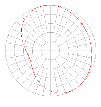 | ||||||||||||||||||
| Azimuth | Ratio | Azimuth | Ratio | Azimuth | Ratio | Azimuth | Ratio | ||||||||||||
| 0 | 0.998 | 10 | 0.985 | 20 | 0.964 | 30 | 0.941 | ||||||||||||
| 40 | 0.920 | 50 | 0.905 | 60 | 0.896 | 70 | 0.893 | ||||||||||||
| 80 | 0.896 | 90 | 0.905 | 100 | 0.920 | 110 | 0.941 | ||||||||||||
| 120 | 0.964 | 130 | 0.985 | 140 | 0.998 | 145 | 1.000 | ||||||||||||
| 150 | 0.998 | 160 | 0.980 | 170 | 0.943 | 180 | 0.888 | ||||||||||||
| 190 | 0.818 | 200 | 0.741 | 210 | 0.663 | 220 | 0.593 | ||||||||||||
| 230 | 0.537 | 240 | 0.502 | 250 | 0.490 | 260 | 0.502 | ||||||||||||
| 270 | 0.537 | 280 | 0.593 | 290 | 0.663 | 300 | 0.741 | ||||||||||||
| 310 | 0.818 | 320 | 0.888 | 330 | 0.943 | 340 | 0.980 | ||||||||||||
| 350 | 0.998 | 355 | 1.000 | ||||||||||||||||
Structure Registration Number 1233693 Structure Type: TOWER Registered To: Gray Media Group, Inc. Structure Address: 12500 South Fm-866 Odessa, TX County Name: Ector County ASR Issued: 09/09/2020 Date Built: 09/01/1955 Site Elevation: 955.6 m (3135 ft.) Structure Height: 198.3 m (651 ft.) Height Overall: 222.5 m (730 ft.) Overall Height AMSL: 1178.1 m (3865 ft.) FAA Determination: 03/27/1998 FAA Study #: 98-ASW-0924-OE Paint & Light FAA Chapters: 1, 3, 6, 15, 21 OM&L TO REMAIN PAINT RED LIGHTS AS PER PRIOR STUDY 98-ASW-0924-OE 31-51-50.8 N 102-34-42.5 W (NAD 83) 31-51-50.4 N 102-34-41.0 W (Converted to NAD 27) |
4370 Peachtree Road, Ne Atlanta, GA 30319 Phone: 404-504-9828 Limited Liability Company | Title: Assistant Secretary Date: 11/27/2020 Application Certifier GRAY TELEVISION LICENSEE, LLC Gray Television Licensee, Llc 4370 Peachtree Road, Ne Atlanta, GA 30319 Applicant Joan Stewart Wiley Rein Llp 1776 K Street Nw Washington, DC 20006 | |||||||||||||||||