
FCCInfo.com
A Service of Cavell, Mertz & Associates, Inc.
(855) FCC-INFO
|
|
W28EE-D from 10/23/2006 |
|
|
|||||||||||||||||||||
|
|
Status: License Application Accepted: 12/30/2020 License Expires: 12/01/2028 File Number: -0000130215 FCC Website Links: LMS Facility Details This Application Other W28EE-D Applications Including Superseded Applications Mailing Address Correspondence for W28EE-D Correspondence related to application -0000130215 Service Contour - Open Street Map or USGS Map (51 dBu) Service Contour - KML / Google Earth (51 dBu) Rabbit Ears Info Search for W28EE-D Site Location: 35-38-14.8 N 82-29-55.5 W (NAD 83) Site Location: 35-38-14.4 N 82-29-56.0 W (Converted to NAD 27) ERP: 3.3 kW Polarization: Horizontally polarized Electrical Beam Tilt: 1 degree R/C AGL: 40 m (131 ft.) R/C AMSL: 1169.8 m (3838 ft.) Emission Mask: Full Service Site Elevation: 1129.8 m. (3707 ft.) Height Overall*: 56.3 m (185 ft.) (* As Filed In This Application, may differ from ASR Data, Below.) Directional Antenna - Antenna Make/Model: Propagation System Inc PSILP8AT-28 Antenna ID: 1007728 Polarization: Horizontally polarized
| |||||||||||||||||||||||
| Antenna Data for Antenna Id: 1007728 W28EE-D LD File: -0000130215 Propagation System Inc - PSILP8AT-28 Service: LD Standard Pattern: N Pattern and Field Values Include a 270° Clockwise Rotation | 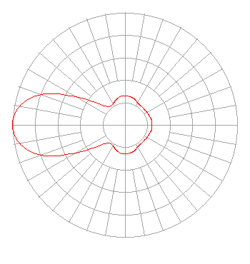 | |||||||||||||||||||||||
| Azimuth | Ratio | Azimuth | Ratio | Azimuth | Ratio | Azimuth | Ratio | |||||||||||||||||
| 0 | 0.260 | 10 | 0.255 | 20 | 0.245 | 30 | 0.225 | |||||||||||||||||
| 40 | 0.220 | 50 | 0.220 | 60 | 0.225 | 70 | 0.230 | |||||||||||||||||
| 80 | 0.240 | 90 | 0.240 | 100 | 0.240 | 110 | 0.230 | |||||||||||||||||
| 120 | 0.225 | 130 | 0.220 | 140 | 0.220 | 150 | 0.225 | |||||||||||||||||
| 160 | 0.245 | 170 | 0.255 | 180 | 0.260 | 190 | 0.255 | |||||||||||||||||
| 200 | 0.235 | 210 | 0.215 | 220 | 0.215 | 230 | 0.280 | |||||||||||||||||
| 240 | 0.500 | 250 | 0.790 | 260 | 0.950 | 270 | 1.000 | |||||||||||||||||
| 280 | 0.950 | 290 | 0.790 | 300 | 0.500 | 310 | 0.280 | |||||||||||||||||
| 320 | 0.215 | 330 | 0.215 | 340 | 0.235 | 350 | 0.255 | |||||||||||||||||
Structure Registration Number 1252866 Structure Type: TOWER Registered To: North Carolina Highway Patrol Structure Address: Atop Peach Knob On Peach Knob Drive Asheville, NC County Name: Buncombe County ASR Issued: 04/07/2006 Date Built: 09/19/2006 Site Elevation: 1129.8 m (3707 ft.) Structure Height: 54.8 m (180 ft.) Height Overall: 56.3 m (185 ft.) Overall Height AMSL: 1186.1 m (3891 ft.) FAA Determination: 03/24/2006 FAA Study #: 2006-ASO-1185-OE Paint & Light FAA Chapters: NONE 35-38-14.8 N 82-29-55.5 W (NAD 83) 35-38-14.4 N 82-29-56.0 W (Converted to NAD 27) |
10 Unc-tv Drive Research Triangle Park, NC 27709 Phone: 919-549-7000 Government Entity | Title: Chief Operating Officer Date: 12/30/2020 Application Certifier University of North Carolina University Of North Carolina 10 Unc-tv Drive Research Triangle Park, NC 27709 Applicant Joseph M. Davis, P.E. Chesapeake Rf Consultants, Llc 207 Old Dominion Road Yorktown, VA 23692 Consulting Engineer Stephen Hartzell Brooks, Pierce Et Al. 150 Fayetteville Street Suite 1700 Raleigh, NC 27601 Donald W Smith University Of North Carolina 10 Unc-tv Drive Research Triangle Park, NC 27709 Marcus W Trathen Brooks, Pierce Et Al. 150 Fayetteville Street Suite 1700 Raleigh, NC 27601 | ||||||||||||||||||||||