
FCCInfo.com
A Service of Cavell, Mertz & Associates, Inc.
(855) FCC-INFO
|
|
WETM-TV from 03/27/1979 |
Post-repack Channel 23 Virtual Channel 18 |  |
|
|||||||||||||||||||||
|
|
Repacking Information: Pre-Repack Channel: 18 Post-Repack Channel: 23 Post-Repack ERP: 50.6 kW Phase: 7 Completion Deadline: 1/17/2020 Find nearby TV Facilities Status: License Application Accepted: 12/18/2020 License Expires: 06/01/2023 File Number: -0000129877 FCC Website Links: LMS Facility Details This Application Other WETM-TV Applications Including Superseded Applications Mailing Address Correspondence for WETM-TV Correspondence related to application -0000129877 Service Contour - Open Street Map or USGS Map (41 dBu) Service Contour - KML / Google Earth (41 dBu) Public Inspection Files History Cards for WETM-TV Rabbit Ears Info Search for WETM-TV Site Location: 42-06-22.0 N 76-52-16.0 W (NAD 83) Site Location: 42-06-21.7 N 76-52-17.1 W (Converted to NAD 27) ERP: 265 kW Polarization: Horizontally polarized HAAT: 375.3 m (1231 ft.) Electrical Beam Tilt: 1 degree R/C AGL: 249 m (817 ft.) R/C AMSL: 769 m (2523 ft.) Site Elevation: 520 m. (1706 ft.) Height Overall*: 256.9 m (843 ft.) (* As Filed In This Application, may differ from ASR Data, Below.) Directional Antenna - Antenna Make/Model: Harris TAD-20UDA 4/40 Antenna ID: 1007700 Polarization: Horizontally polarized | ||||||||||||||||||||||||
| Antenna Data for Antenna Id: 1007700 WETM-TV DT File: -0000129877 Harris - TAD-20UDA 4/40 Service: DT Standard Pattern: N | 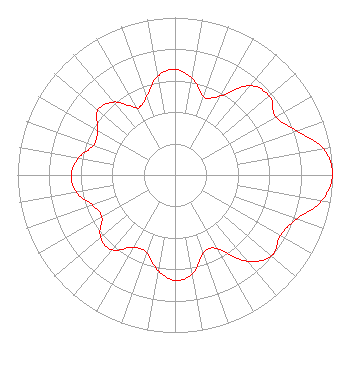 | ||||||||||||||||||||||||
| Azimuth | Ratio | Azimuth | Ratio | Azimuth | Ratio | Azimuth | Ratio | ||||||||||||||||||
| 0 | 0.670 | 10 | 0.625 | 20 | 0.528 | 30 | 0.580 | ||||||||||||||||||
| 40 | 0.741 | 50 | 0.780 | 60 | 0.740 | 70 | 0.821 | ||||||||||||||||||
| 80 | 0.957 | 90 | 1.000 | 100 | 0.945 | 110 | 0.819 | ||||||||||||||||||
| 120 | 0.772 | 130 | 0.800 | 140 | 0.715 | 150 | 0.539 | ||||||||||||||||||
| 160 | 0.526 | 170 | 0.638 | 180 | 0.669 | 190 | 0.617 | ||||||||||||||||||
| 200 | 0.524 | 210 | 0.529 | 220 | 0.621 | 230 | 0.617 | ||||||||||||||||||
| 240 | 0.537 | 250 | 0.557 | 260 | 0.636 | 270 | 0.660 | ||||||||||||||||||
| 280 | 0.622 | 290 | 0.550 | 300 | 0.567 | 310 | 0.639 | ||||||||||||||||||
| 320 | 0.605 | 330 | 0.497 | 333 | 0.488 | 340 | 0.530 | ||||||||||||||||||
| 350 | 0.635 | ||||||||||||||||||||||||
Structure Registration Number 1010439 Structure Type: GTOWER Registered To: Nexstar Media Inc. Structure Address: Off Of Television Rd On Hawley Hill Elmira, NY County Name: Chemung County ASR Issued: 12/13/2023 Date Built: 09/01/1963 Site Elevation: 520 m (1706 ft.) Structure Height: 243.5 m (799 ft.) Height Overall: 256.9 m (843 ft.) Overall Height AMSL: 776.9 m (2549 ft.) FAA Determination: 12/01/2023 FAA Study #: 2022-AEA-14594-OE FAA Circular #: 70/7460-1M Paint & Light FAA Chapters: 3, 4, 5, 15 PRIOR STUDY 1996-AEA-1273-OE 42-06-22.9 N 76-52-16.4 W (NAD 83) 42-06-22.6 N 76-52-17.5 W (Converted to NAD 27) |
545 E. John W. Carpenter Freeway Suite 700 Irving, TX 75062 Phone: 972-373-8800 Corporation | Title: General Counsel Date: 12/18/2020 Application Certifier Nexstar Inc. 545 E. John W. Carpenter Freeway Suite 700 Irving, TX 75062 Applicant William T. Godfrey, Jr Kessler And Gehman Associates, Inc. Kessler And Gehman Associates, Inc. 507-d Nw 60th Street Gainesville, FL 32607-2055 Consulting Engineers Elizabeth Ryder Nexstar Inc. 545 E John Carpenter Freeway Suite 700 Irving, TX 75062 General Counsel | |||||||||||||||||||||||
| |||||||||||||||||||||||||