
FCCInfo.com
A Service of Cavell, Mertz & Associates, Inc.
(855) FCC-INFO
|
|
KTWM-LD from 01/11/2002 KTWM-LD from 09/26/1985 |
|
|
||||||||||||||||
|
|
Status: Construction Permit Application Accepted: 01/04/2021 KTWM-LD CP Expires: 03/04/2024 File Number: -0000130317 FCC Website Links: LMS Facility Details This Application Other KTWM-LD Applications Including Superseded Applications Mailing Address Correspondence for KTWM-LD Correspondence related to application -0000130317 Service Contour - Open Street Map or USGS Map (51 dBu) Service Contour - KML / Google Earth (51 dBu) Rabbit Ears Info Search for KTWM-LD Site Location: 33-58-20.4 N 98-45-36.1 W (NAD 83) Site Location: 33-58-20.1 N 98-45-34.9 W (Converted to NAD 27) ERP: 15 kW Polarization: Horizontally polarized Electrical Beam Tilt: 1.0 degree R/C AGL: 86.7 m (284 ft.) R/C AMSL: 400 m (1312 ft.) Emission Mask: Full Service Site Elevation: 313.3 m. (1028 ft.) Height Overall*: 95.4 m (313 ft.) (* As Filed In This Application, may differ from ASR Data, Below.) Directional Antenna - Antenna Make/Model: Propagation System Inc PSILP16AER Antenna ID: 1007738 Polarization: Horizontally polarized | ||||||||||||||||||
| Antenna Data for Antenna Id: 1007738 KTWM-LD LD File: -0000130317 Propagation System Inc - PSILP16AER Service: LD Standard Pattern: N Pattern and Field Values Include a 100° Clockwise Rotation | 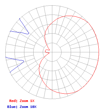 | ||||||||||||||||||
| Azimuth | Ratio | Azimuth | Ratio | Azimuth | Ratio | Azimuth | Ratio | ||||||||||||
| 0 | 0.624 | 10 | 0.725 | 20 | 0.815 | 30 | 0.886 | ||||||||||||
| 40 | 0.946 | 50 | 0.988 | 60 | 1.000 | 70 | 1.000 | ||||||||||||
| 80 | 1.000 | 90 | 1.000 | 100 | 1.000 | 110 | 1.000 | ||||||||||||
| 120 | 1.000 | 130 | 1.000 | 140 | 1.000 | 150 | 0.988 | ||||||||||||
| 160 | 0.946 | 170 | 0.886 | 180 | 0.815 | 190 | 0.725 | ||||||||||||
| 200 | 0.624 | 210 | 0.529 | 220 | 0.428 | 230 | 0.293 | ||||||||||||
| 240 | 0.146 | 250 | 0.067 | 260 | 0.085 | 270 | 0.136 | ||||||||||||
| 280 | 0.147 | 290 | 0.136 | 300 | 0.085 | 310 | 0.067 | ||||||||||||
| 320 | 0.146 | 330 | 0.293 | 340 | 0.428 | 350 | 0.529 | ||||||||||||
Structure Registration Number 1231196 Structure Type: TOWER Registered To: American Towers LLC Structure Address: Hwy 287 & East Of Burnett Rd (092104) Iowa Park, TX County Name: Wichita County ASR Issued: 06/24/2016 Date Built: 01/06/2002 Site Elevation: 313.3 m (1028 ft.) Structure Height: 91.4 m (300 ft.) Height Overall: 95.4 m (313 ft.) Overall Height AMSL: 408.7 m (1341 ft.) FAA Determination: 05/20/2009 FAA Study #: 2009-ASW-2455-OE FAA Circular #: 70/7460-1K Paint & Light FAA Chapters: 4, 8, 12 PRIOR STUDY 2004-ASW-1660-OE 33-58-20.4 N 98-45-36.1 W (NAD 83) 33-58-20.1 N 98-45-34.9 W (Converted to NAD 27) |
Chattanooga, TN 37401 Phone: 423-468-5100 Limited Liability Company | Title: Coo Date: 01/04/2021 Application Certifier Digital Networks-Midwest, LLC Digital Networks-midwest, Llc Chattanooga, TN 37401 Applicant Jeremy D Ruck, PE Jeremy Ruck & Associates, Inc. Canton, IL 61520 Consulting Engineer Aaron P Shainis Shainis & Peltzman, Chartered 1850 M St. Nw Suite 240 Washington, DC 20036 FCC Legal Counsel | |||||||||||||||||