
FCCInfo.com
A Service of Cavell, Mertz & Associates, Inc.
(855) FCC-INFO
|
|
WMUB-LD from 07/03/2010 WMUB-LD from 12/08/2009 |
|
|
||||||||||||||||
|
|
Status: License Application Accepted: 02/02/2021 License Expires: 04/01/2021 File Number: -0000135124 FCC Website Links: LMS Facility Details This Application Other WMUB-LD Applications Including Superseded Applications Mailing Address Correspondence for WMUB-LD Correspondence related to application -0000135124 Service Contour - Open Street Map or USGS Map (51 dBu) Service Contour - KML / Google Earth (51 dBu) Rabbit Ears Info Search for WMUB-LD Site Location: 32-45-52.0 N 83-33-32.0 W (NAD 83) Site Location: 32-45-51.5 N 83-33-32.3 W (Converted to NAD 27) ERP: 15 kW Polarization: Horizontally polarized Electrical Beam Tilt: 1.5 degrees R/C AGL: 182 m (597 ft.) R/C AMSL: 332.9 m (1092 ft.) Emission Mask: Full Service Site Elevation: 150.9 m. (495 ft.) Height Overall*: 194 m (636 ft.) (* As Filed In This Application, may differ from ASR Data, Below.) Directional Antenna - Antenna Make/Model: Dielectric DLP-8B Antenna ID: 1007823 Polarization: Horizontally polarized | ||||||||||||||||||
| Antenna Data for Antenna Id: 1007823 WMUB-LD LD File: -0000135124 Dielectric - DLP-8B Service: LD Standard Pattern: N Pattern and Field Values Include a 305° Clockwise Rotation | 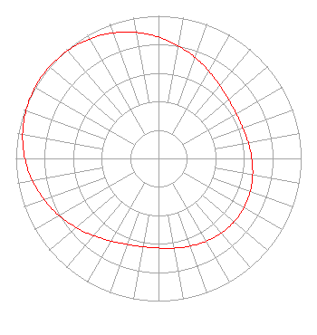 | ||||||||||||||||||
| Azimuth | Ratio | Azimuth | Ratio | Azimuth | Ratio | Azimuth | Ratio | ||||||||||||
| 5 | 0.828 | 15 | 0.778 | 25 | 0.729 | 35 | 0.686 | ||||||||||||
| 45 | 0.653 | 55 | 0.633 | 65 | 0.627 | 75 | 0.632 | ||||||||||||
| 85 | 0.646 | 95 | 0.662 | 105 | 0.678 | 115 | 0.688 | ||||||||||||
| 125 | 0.692 | 135 | 0.688 | 145 | 0.678 | 155 | 0.662 | ||||||||||||
| 165 | 0.646 | 175 | 0.632 | 185 | 0.627 | 195 | 0.633 | ||||||||||||
| 205 | 0.653 | 215 | 0.686 | 225 | 0.729 | 235 | 0.778 | ||||||||||||
| 245 | 0.828 | 255 | 0.875 | 265 | 0.918 | 275 | 0.953 | ||||||||||||
| 285 | 0.979 | 295 | 0.995 | 305 | 1.000 | 315 | 0.995 | ||||||||||||
| 325 | 0.979 | 335 | 0.953 | 345 | 0.918 | 355 | 0.875 | ||||||||||||
Structure Registration Number 1045776 [ASR Heights Differ from WMUB-LD Application] Structure Type: GTOWER Registered To: Macon Urban Ministries, Inc Structure Address: 5950 Ocmulgee East Blvd (9at0619e) Macon, GA County Name: Bibb County ASR Issued: 07/12/2023 Date Built: 06/02/1999 Site Elevation: 147.2 m (483 ft.) Structure Height: 192 m (630 ft.) Height Overall: 194.2 m (637 ft.) Overall Height AMSL: 341.4 m (1120 ft.) FAA Determination: 06/15/2023 FAA Study #: 2022-ASO-39227-OE FAA Circular #: 70/7460-1M Paint & Light FAA Chapters: 4, 8, 15 PRIOR STUDY 1997-ASO-6564-OE 32-45-55.2 N 83-33-32.1 W (NAD 83) 32-45-54.7 N 83-33-32.4 W (Converted to NAD 27) |
1501 Mercer University Drive Macon, GA 31207 Phone: 478-301-2771 Private Not-for-Profit Educational Institution | Title: Executive Vice President Administration And Finance Date: 02/02/2021 Application Certifier The Corporation Of Mercer University 1501 Mercer University Drive Macon, GA 31207 Applicant Derek Teslik Gray Miller Persh Llp 2233 Wisconsin Avenue, Nw Suite 226 Washington, DC 22182 Barry S. Persh Gray Miller Persh Llp 2233 Wisconsin Avenue Nw Suite 226 Washington, DC 20007 | |||||||||||||||||
| |||||||||||||||||||