
FCCInfo.com
A Service of Cavell, Mertz & Associates, Inc.
(855) FCC-INFO
|
|
WDCO-CD from 04/06/2015 WDCO-CD from 03/30/2015 WDCO-CD from 06/18/2002 WDCO-CD from 12/30/1994 WDCO-CD from 04/30/1985 |
Post-repack Channel 24 |
|
||||||||||||||||
|
|
Repacking Information: Pre-Repack Channel: 45 Post-Repack Channel: 24 Post-Repack ERP: 3.58 kW Phase: 4 Completion Deadline: 8/2/2019 Find nearby TV Facilities Status: License Application Accepted: 03/09/2021 License Expires: 10/01/2028 File Number: -0000138193 FCC Website Links: LMS Facility Details This Application Other WDCO-CD Applications Including Superseded Applications Mailing Address Correspondence for WDCO-CD Correspondence related to application -0000138193 Service Contour - Open Street Map or USGS Map (51 dBu) Service Contour - KML / Google Earth (51 dBu) Public Inspection Files Rabbit Ears Info Search for WDCO-CD Site Location: 38-56-24.2 N 77-04-52.5 W (NAD 83) Site Location: 38-56-23.8 N 77-04-53.6 W (Converted to NAD 27) ERP: 15 kW Polarization: Elliptically polarized R/C AGL: 100.6 m (330 ft.) R/C AMSL: 220.1 m (722 ft.) Emission Mask: Full Service Site Elevation: 119.5 m. (392 ft.) Height Overall*: 135 m (443 ft.) (* As Filed In This Application, may differ from ASR Data, Below.) Directional Antenna - Antenna Make/Model: DIELECTRIC TFU-12DSB/VP-BB-B Antenna ID: 1007935 Polarization: Elliptically polarized | ||||||||||||||||||
| Antenna Data for Antenna Id: 1007935 WDCO-CD DC File: -0000138193 DIELECTRIC - TFU-12DSB/VP-BB-B Service: DC Standard Pattern: N Pattern and Field Values Include a 335° Clockwise Rotation | 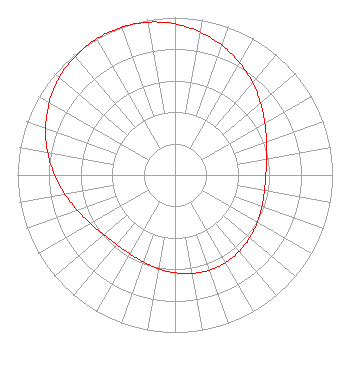 | ||||||||||||||||||
| Azimuth | Ratio | Azimuth | Ratio | Azimuth | Ratio | Azimuth | Ratio | ||||||||||||
| 5 | 0.942 | 15 | 0.899 | 25 | 0.849 | 35 | 0.793 | ||||||||||||
| 45 | 0.737 | 55 | 0.683 | 65 | 0.637 | 75 | 0.603 | ||||||||||||
| 85 | 0.582 | 95 | 0.575 | 105 | 0.581 | 115 | 0.595 | ||||||||||||
| 125 | 0.612 | 135 | 0.628 | 145 | 0.639 | 155 | 0.643 | ||||||||||||
| 165 | 0.639 | 175 | 0.628 | 185 | 0.612 | 195 | 0.595 | ||||||||||||
| 205 | 0.581 | 215 | 0.575 | 225 | 0.582 | 235 | 0.603 | ||||||||||||
| 245 | 0.637 | 255 | 0.683 | 265 | 0.737 | 275 | 0.793 | ||||||||||||
| 285 | 0.849 | 295 | 0.899 | 305 | 0.942 | 315 | 0.974 | ||||||||||||
| 325 | 0.993 | 335 | 1.000 | 345 | 0.993 | 355 | 0.974 | ||||||||||||
Structure Registration Number 1285336 Structure Type: LTOWER Registered To: American Towers LLC Structure Address: 4001 Nebraska Ave. Nw Washington, DC County Name: District of Columbia ASR Issued: 04/14/2014 Date Built: 01/01/1957 Site Elevation: 119.5 m (392 ft.) Structure Height: 112.8 m (370 ft.) Height Overall: 135 m (443 ft.) Overall Height AMSL: 254.5 m (835 ft.) FAA Determination: 07/11/2012 FAA Study #: 2012-AEA-2930-OE Paint & Light FAA Chapters: NONE PRIOR STUDY 2012-AEA-1892-OE 38-56-24.2 N 77-04-52.5 W (NAD 83) 38-56-23.8 N 77-04-53.6 W (Converted to NAD 27) |
C/o Miles S. Mason, Pillsbury Winthrop Shaw Pittman Llp 1200 Seventeenth Street, Nw Washington, DC 20036 Phone: 202-663-8195 Limited Liability Company | Title: Evp And Cfo, Sinclair Broadcast Group, Inc Date: 03/09/2021 Application Certifier Acc Licensee, Llc C/o Miles S. Mason, Pillsbury Winthrop Shaw Pittman Llp 1200 Seventeenth Street, Nw Washington, DC 20036 Applicant Miles S. Mason, Esq Pillsbury Winthrop Shaw Pittman Llp 1200 Seventeenth Street, Nw Washington, DC 20036 | |||||||||||||||||