
FCCInfo.com
A Service of Cavell, Mertz & Associates, Inc.
(855) FCC-INFO
|
|
|
|
|
||||||||||||||||
|
|
Status: License Application Accepted: 03/12/2021 License Expires: 02/01/2029 File Number: -0000139080 FCC Website Links: LMS Facility Details This Application Other W11DH-D Applications Including Superseded Applications Mailing Address Correspondence for W11DH-D Correspondence related to application -0000139080 Service Contour - Open Street Map or USGS Map (48 dBu) Service Contour - KML / Google Earth (48 dBu) Rabbit Ears Info Search for W11DH-D Site Location: 27-16-31.0 N 80-17-10.2 W (NAD 83) Site Location: 27-16-29.8 N 80-17-11.0 W (Converted to NAD 27) ERP: 1.5 kW Polarization: Horizontally polarized Electrical Beam Tilt: 2.5 degrees R/C AGL: 116 m (381 ft.) R/C AMSL: 120.3 m (395 ft.) Emission Mask: Full Service Site Elevation: 4.3 m. (14 ft.) Height Overall*: 152.4 m (500 ft.) (* As Filed In This Application, may differ from ASR Data, Below.) Directional Antenna - Antenna Make/Model: Scala CL-713 ARRAY Antenna ID: 1007958 Polarization: Horizontally polarized | ||||||||||||||||||
| Antenna Data for Antenna Id: 1007958 W11DH-D LD File: -0000139080 Scala - CL-713 ARRAY Service: LD Standard Pattern: N Pattern and Field Values Include a 343° Clockwise Rotation | 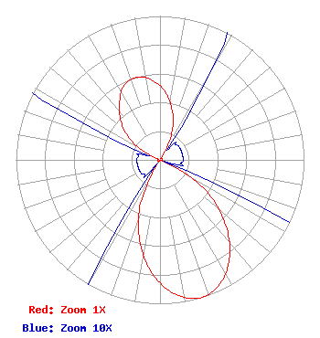 | ||||||||||||||||||
| Azimuth | Ratio | Azimuth | Ratio | Azimuth | Ratio | Azimuth | Ratio | ||||||||||||
| 3 | 0.486 | 13 | 0.364 | 23 | 0.220 | 33 | 0.027 | ||||||||||||
| 43 | 0.016 | 53 | 0.016 | 63 | 0.016 | 73 | 0.016 | ||||||||||||
| 83 | 0.016 | 93 | 0.016 | 103 | 0.016 | 113 | 0.035 | ||||||||||||
| 123 | 0.358 | 133 | 0.602 | 143 | 0.808 | 153 | 0.946 | ||||||||||||
| 163 | 1.000 | 173 | 0.946 | 183 | 0.808 | 193 | 0.602 | ||||||||||||
| 203 | 0.358 | 213 | 0.035 | 223 | 0.016 | 233 | 0.016 | ||||||||||||
| 243 | 0.016 | 253 | 0.016 | 263 | 0.016 | 273 | 0.016 | ||||||||||||
| 283 | 0.016 | 293 | 0.027 | 303 | 0.220 | 313 | 0.364 | ||||||||||||
| 323 | 0.468 | 333 | 0.566 | 343 | 0.597 | 353 | 0.566 | ||||||||||||
Structure Registration Number 1052692 Structure Type: GTOWER Registered To: Vertical Bridge CC FM, LLC Structure Address: 3771 Jennings Road / Us-fl-5013 Port St. Lucie, FL County Name: St. Lucie County ASR Issued: 11/25/2020 Date Built: 07/23/2002 Site Elevation: 4.3 m (14 ft.) Structure Height: 151 m (495 ft.) Height Overall: 152.4 m (500 ft.) Overall Height AMSL: 156.7 m (514 ft.) FAA Determination: 10/07/2020 FAA Study #: 2020-ASO-29666-OE FAA Circular #: 70/7460-1L Paint & Light FAA Chapters: 4, 8, 12 PRIOR STUDY 2015-ASO-10148-OE 27-16-31.0 N 80-17-10.2 W (NAD 83) 27-16-29.8 N 80-17-11.0 W (Converted to NAD 27) |
16280 Nw 17th Street Pembroke Pines, FL 33028 Phone: 954-812-7381 Applicant | Title: Licensee Date: 03/12/2021 Application Certifier FRANCOIS LECONTE Francois Leconte 16280 Nw 17th Street Pembroke Pines, FL 33028 Applicant Greg Best Greg Best Consulting, Inc. 16100 Outlook Ave Stilwell, KS 66085 CONSULTING ENGINEER | |||||||||||||||||