
FCCInfo.com
A Service of Cavell, Mertz & Associates, Inc.
(855) FCC-INFO
|
|
|
|
|
||||||||||||||||
|
|
Status: Construction Permit Application Accepted: 04/20/2021 KJLN-LD CP Expires: 04/26/2024 File Number: -0000143697 FCC Website Links: LMS Facility Details This Application Other KJLN-LD Applications Including Superseded Applications Mailing Address Correspondence for KJLN-LD Correspondence related to application -0000143697 Service Contour - Open Street Map or USGS Map (51 dBu) Service Contour - KML / Google Earth (51 dBu) Rabbit Ears Info Search for KJLN-LD Site Location: 37-04-38.0 N 94-30-16.5 W (NAD 83) Site Location: 37-04-37.8 N 94-30-15.7 W (Converted to NAD 27) ERP: 15 kW Polarization: Horizontally polarized Electrical Beam Tilt: 1.0 degree R/C AGL: 72.8 m (239 ft.) R/C AMSL: 374 m (1227 ft.) Emission Mask: Full Service Site Elevation: 301.2 m. (988 ft.) Height Overall*: 82.3 m (270 ft.) (* As Filed In This Application, may differ from ASR Data, Below.) Directional Antenna - Antenna Make/Model: Propagation System Inc PSILP16BA Antenna ID: 1008095 Polarization: Horizontally polarized | ||||||||||||||||||
| Antenna Data for Antenna Id: 1008095 KJLN-LD LD File: -0000143697 Propagation System Inc - PSILP16BA Service: LD Standard Pattern: N Pattern and Field Values Include a 325° Clockwise Rotation | 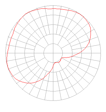 | ||||||||||||||||||
| Azimuth | Ratio | Azimuth | Ratio | Azimuth | Ratio | Azimuth | Ratio | ||||||||||||
| 5 | 0.930 | 15 | 0.940 | 25 | 0.970 | 35 | 0.990 | ||||||||||||
| 45 | 0.980 | 55 | 0.950 | 65 | 0.870 | 75 | 0.770 | ||||||||||||
| 85 | 0.630 | 95 | 0.470 | 105 | 0.350 | 115 | 0.230 | ||||||||||||
| 125 | 0.210 | 135 | 0.220 | 145 | 0.230 | 155 | 0.220 | ||||||||||||
| 165 | 0.210 | 175 | 0.230 | 185 | 0.350 | 195 | 0.470 | ||||||||||||
| 205 | 0.630 | 215 | 0.770 | 225 | 0.870 | 235 | 0.950 | ||||||||||||
| 245 | 0.980 | 255 | 0.990 | 265 | 0.970 | 275 | 0.940 | ||||||||||||
| 285 | 0.930 | 295 | 0.930 | 305 | 0.960 | 315 | 0.980 | ||||||||||||
| 325 | 1.000 | 335 | 0.980 | 345 | 0.960 | 355 | 0.930 | ||||||||||||
Structure Registration Number 1020777 Structure Type: LTOWER Registered To: American Towers, LLC Structure Address: Markwardt St (305883) Joplin, MO County Name: Jasper County ASR Issued: 02/07/2020 Date Built: 08/01/1987 Site Elevation: 301.2 m (988 ft.) Structure Height: 76.2 m (250 ft.) Height Overall: 82.3 m (270 ft.) Overall Height AMSL: 383.5 m (1258 ft.) FAA Determination: 10/11/2012 FAA Study #: 2012-ACE-2944-OE Paint & Light FAA Chapters: A1, H, 3, 11, 21, 23 Continue As Is OM&L = A MED-DUAL SYSTEM 37-04-38.0 N 94-30-16.5 W (NAD 83) 37-04-37.8 N 94-30-15.7 W (Converted to NAD 27) |
Po Box 11409 Chattanooga, TN 37401 Phone: 423-468-5100 Limited Liability Company | Title: Coo Date: 04/20/2021 Application Certifier Digital Networks-Midwest, LLC Digital Networks-midwest, Llc Chattanooga, TN 37401 Applicant Aaron P Shainis, Esq Shainis & Peltzman, Chartered 1850 M Street Nw Suite 240 Washington, DC 20036 FCC Counsel Jeremy D Ruck, PE Jeremy Ruck & Associates, Inc. Canton, IL 61520 Consulting Engineer | |||||||||||||||||