
FCCInfo.com
A Service of Cavell, Mertz & Associates, Inc.
(855) FCC-INFO
|
|
|
Virtual Channel 27 |
|
|||||||||||||||||||||||||
|
|
Repacking Information: No changes Status: Construction Permit Application Accepted: 05/14/2021 KCWV CP Expires: 11/23/2024 File Number: -0000036079 FCC Website Links: LMS Facility Details This Application Other KCWV Applications Including Superseded Applications Mailing Address Correspondence for KCWV Correspondence related to application -0000036079 Service Contour - Open Street Map or USGS Map (41 dBu) Service Contour - KML / Google Earth (41 dBu) Public Inspection Files Rabbit Ears Info Search for KCWV Site Location: 46-47-07.0 N 92-07-16.0 W (NAD 83) Site Location: 46-47-07.2 N 92-07-15.3 W (Converted to NAD 27) ERP: 62.5 kW Polarization: Horizontally polarized HAAT: 218.1 m (716 ft.) Electrical Beam Tilt: 0.75 degrees R/C AGL: 148.4 m (487 ft.) R/C AMSL: 524.2 m (1720 ft.) Site Elevation: 375.8 m. (1233 ft.) Height Overall*: 153.6 m (504 ft.) (* As Filed In This Application, may differ from ASR Data, Below.) Directional Antenna - Antenna Make/Model: Electronics Research Inc. ALP16L3-HSE-27 Antenna ID: 94742 Polarization: Horizontally polarized
| |||||||||||||||||||||||||||
| Antenna Data for Antenna Id: 94742 KCWV DT File: -0000036079 Electronics Research Inc. - ALP16L3-HSE-27 Service: DT Standard Pattern: Y Pattern and Field Values Include a 135° Clockwise Rotation | 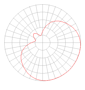 | |||||||||||||||||||||||||||
| Azimuth | Ratio | Azimuth | Ratio | Azimuth | Ratio | Azimuth | Ratio | |||||||||||||||||||||
| 5 | 0.340 | 15 | 0.476 | 25 | 0.597 | 35 | 0.687 | |||||||||||||||||||||
| 45 | 0.758 | 55 | 0.826 | 65 | 0.890 | 75 | 0.944 | |||||||||||||||||||||
| 85 | 0.979 | 95 | 0.996 | 105 | 0.999 | 115 | 0.999 | |||||||||||||||||||||
| 125 | 0.999 | 135 | 1.000 | 145 | 0.999 | 155 | 0.999 | |||||||||||||||||||||
| 165 | 0.999 | 175 | 0.996 | 185 | 0.979 | 195 | 0.944 | |||||||||||||||||||||
| 205 | 0.890 | 215 | 0.826 | 225 | 0.758 | 235 | 0.687 | |||||||||||||||||||||
| 245 | 0.597 | 255 | 0.476 | 265 | 0.340 | 275 | 0.229 | |||||||||||||||||||||
| 285 | 0.188 | 295 | 0.222 | 305 | 0.287 | 315 | 0.322 | |||||||||||||||||||||
| 325 | 0.287 | 335 | 0.222 | 345 | 0.188 | 355 | 0.229 | |||||||||||||||||||||
Structure Registration Number 1298032 Structure Type: GTOWER Registered To: RADIANT LIFE MINISTRIES, INC. Structure Address: Observation Rd Duluth, MN County Name: St. Louis County ASR Issued: 06/10/2021 Date Built: 09/01/2015 Site Elevation: 375.8 m (1233 ft.) Structure Height: 152.7 m (501 ft.) Height Overall: 153.6 m (504 ft.) Overall Height AMSL: 529.4 m (1737 ft.) FAA Determination: 11/25/2015 FAA Study #: 2015-AGL-13729-OE Paint & Light FAA Chapters: 1, 3, 4, 13, 21 Continue As Is OM&L = PAINT/RED LIGHTS 46-47-07.0 N 92-07-16.0 W (NAD 83) 46-47-07.2 N 92-07-15.3 W (Converted to NAD 27) |
Marion, IL 62959 Phone: 618-997-4700 Not-for-Profit | Title: President Date: 05/14/2021 Application Certifier Radiant Life Ministries, Inc. Marion, IL 62959 Applicant Kevin T. Fisher Smith And Fisher, Llc 4791 Wintergreen Court Woodbridge, VA 22192 Engineering Consultant Joseph C Chautin, III Hardy, Carey, Chautin & Balkin, Llp 1080 West Causeway Approach Mandeville, LA 70471 Attorney-At-Law | ||||||||||||||||||||||||||