
FCCInfo.com
A Service of Cavell, Mertz & Associates, Inc.
(855) FCC-INFO
|
|
K21OB-D from 03/15/2004 |
|
|
||||||||||||||||
|
|
Status: License Application Accepted: 05/27/2021 License Expires: 06/01/2021 File Number: -0000147610 FCC Website Links: LMS Facility Details This Application Other K21OB-D Applications Including Superseded Applications Mailing Address Correspondence for K21OB-D Correspondence related to application -0000147610 Service Contour - Open Street Map or USGS Map (51 dBu) Service Contour - KML / Google Earth (51 dBu) Rabbit Ears Info Search for K21OB-D Site Location: 30-16-46.3 N 93-14-45.4 W (NAD 83) Site Location: 30-16-45.6 N 93-14-44.8 W (Converted to NAD 27) ERP: 10 kW Polarization: Circularly polarized Electrical Beam Tilt: 0.50 degrees R/C AGL: 90 m (295 ft.) R/C AMSL: 96.4 m (316 ft.) Emission Mask: Full Service Site Elevation: 6.4 m. (21 ft.) Height Overall*: 128.6 m (422 ft.) (* As Filed In This Application, may differ from ASR Data, Below.) Directional Antenna - Antenna Make/Model: Propagation System Inc PSILP08OI Antenna ID: 1008231 Polarization: Circularly polarized | ||||||||||||||||||
| Antenna Data for Antenna Id: 1008231 K21OB-D LD File: -0000147610 Propagation System Inc - PSILP08OI Service: LD Standard Pattern: N Pattern and Field Values Include a 143.0° Clockwise Rotation | 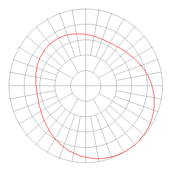 | ||||||||||||||||||
| Azimuth | Ratio | Azimuth | Ratio | Azimuth | Ratio | Azimuth | Ratio | ||||||||||||
| 3 | 0.661 | 13 | 0.646 | 23 | 0.639 | 33 | 0.644 | ||||||||||||
| 43 | 0.662 | 53 | 0.692 | 63 | 0.733 | 73 | 0.780 | ||||||||||||
| 83 | 0.829 | 93 | 0.876 | 103 | 0.918 | 113 | 0.953 | ||||||||||||
| 123 | 0.979 | 133 | 0.995 | 143 | 1.000 | 153 | 0.995 | ||||||||||||
| 163 | 0.979 | 173 | 0.953 | 183 | 0.918 | 193 | 0.876 | ||||||||||||
| 203 | 0.829 | 213 | 0.780 | 223 | 0.733 | 233 | 0.692 | ||||||||||||
| 243 | 0.662 | 253 | 0.644 | 263 | 0.639 | 273 | 0.646 | ||||||||||||
| 283 | 0.661 | 293 | 0.678 | 303 | 0.694 | 313 | 0.705 | ||||||||||||
| 323 | 0.709 | 333 | 0.705 | 343 | 0.694 | 353 | 0.678 | ||||||||||||
Structure Registration Number 1022607 Structure Type: Registered To: American Towers LLC Structure Address: 309 Fletcher Rd (035791 / Westlake 1b) Westlake, LA County Name: Calcasieu Parish ASR Issued: 06/17/2016 Date Built: 05/16/2008 Site Elevation: 6.4 m (21 ft.) Structure Height: 121.9 m (400 ft.) Height Overall: 128.6 m (422 ft.) Overall Height AMSL: 135 m (443 ft.) FAA Determination: 07/27/2007 FAA Study #: 2007-ASW-6408-OE FAA Circular #: 70/7460-1K Paint & Light FAA Chapters: 4, 8, 12 OM&L to remain the same as prior study = A MED-DUAL SYSTEM 30-16-46.3 N 93-14-45.4 W (NAD 83) 30-16-45.6 N 93-14-44.8 W (Converted to NAD 27) |
104 Woodmont Montgomery, TX 77356 Phone: 936-443-4451 Applicant | Title: Manager Date: 05/27/2021 Application Certifier WINDSONG COMMUNICATIONS, INC Windsong Communications, Inc 104 Woodmont Montgomery, TX 77356 Applicant JIM McPhetridge Wes Broadcast Consultants, Inc. 228 Flynn Drive. El Paso, TX 79932 CONSULTING ENGINEER JAMES L. Oyster Law Offices Of James L. Oyster 108 Oyster Lane Castleton, VA 22716 | |||||||||||||||||