
FCCInfo.com
A Service of Cavell, Mertz & Associates, Inc.
(855) FCC-INFO
|
|
|
Virtual Channel 34 |  |
|
|||||||||||||||
|
|
Repacking Information: No changes Status: License Application Accepted: 06/09/2021 License Expires: 12/01/2021 File Number: -0000149930 FCC Website Links: LMS Facility Details This Application Other WYOW Applications Including Superseded Applications Mailing Address Correspondence for WYOW Correspondence related to application -0000149930 Service Contour - Open Street Map or USGS Map (41 dBu) Service Contour - KML / Google Earth (41 dBu) Public Inspection Files Rabbit Ears Info Search for WYOW Site Location: 45-46-29.8 N 89-14-55.5 W (NAD 83) Site Location: 45-46-30.0 N 89-14-55.0 W (Converted to NAD 27) ERP: 80 kW Polarization: Horizontally polarized HAAT: 163 m (535 ft.) Electrical Beam Tilt: 1 degree R/C AGL: 149 m (489 ft.) R/C AMSL: 661.1 m (2169 ft.) Site Elevation: 512.1 m. (1680 ft.) Height Overall*: 152.1 m (499 ft.) (* As Filed In This Application, may differ from ASR Data, Below.) Directional Antenna - Antenna Make/Model: DIELECTRIC TFU-8DSB-G Antenna ID: 110814 Polarization: Horizontally polarized | ||||||||||||||||||
| Antenna Data for Antenna Id: 110814 WYOW DT File: -0000149930 DIELECTRIC - TFU-8DSB-G Service: DT Standard Pattern: Y Pattern and Field Values Include a 235° Clockwise Rotation | 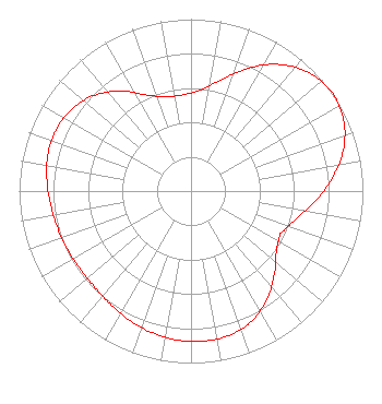 | ||||||||||||||||||
| Azimuth | Ratio | Azimuth | Ratio | Azimuth | Ratio | Azimuth | Ratio | ||||||||||||
| 5 | 0.588 | 15 | 0.668 | 25 | 0.789 | 35 | 0.899 | ||||||||||||
| 45 | 0.973 | 55 | 1.000 | 65 | 0.980 | 75 | 0.917 | ||||||||||||
| 85 | 0.823 | 95 | 0.721 | 105 | 0.632 | 115 | 0.580 | ||||||||||||
| 117 | 0.579 | 125 | 0.607 | 135 | 0.685 | 145 | 0.770 | ||||||||||||
| 155 | 0.836 | 165 | 0.868 | 175 | 0.876 | 185 | 0.870 | ||||||||||||
| 195 | 0.854 | 205 | 0.832 | 215 | 0.809 | 225 | 0.791 | ||||||||||||
| 235 | 0.788 | 245 | 0.796 | 255 | 0.806 | 265 | 0.822 | ||||||||||||
| 275 | 0.842 | 285 | 0.860 | 291 | 0.863 | 295 | 0.861 | ||||||||||||
| 305 | 0.839 | 315 | 0.790 | 325 | 0.710 | 335 | 0.618 | ||||||||||||
| 345 | 0.568 | 352 | 0.560 | 355 | 0.561 | ||||||||||||||
Structure Registration Number 1059095 Structure Type: TOWER Registered To: Gray Media Group, Inc. Structure Address: 6425 Thunder Lake Rd Rhinelander, WI County Name: Oneida County ASR Issued: 08/03/2021 Date Built: 12/21/2000 Site Elevation: 512.1 m (1680 ft.) Structure Height: 151 m (495 ft.) Height Overall: 152.1 m (499 ft.) Overall Height AMSL: 664.2 m (2179 ft.) FAA Determination: 05/25/2000 FAA Study #: 00-AGL-1161-OE FAA Circular #: 70/7460-1K Paint & Light FAA Chapters: 3, 4, 5, 12 Removed expiration and final dates from determination. Scenario 2./jjs/case#635066 45-46-29.8 N 89-14-55.5 W (NAD 83) 45-46-30.0 N 89-14-55.0 W (Converted to NAD 27) |
4370 Peachtree Road, Ne Atlanta, GA 30319 Phone: 404-504-9828 Limited Liability Company | Title: President Date: 06/09/2021 Application Certifier WAOW-WYOW LICENSE, LLC Waow-wyow License, Llc P.o. Box 909 Quincy, IL 62306 Applicant Scott Turpie Lohnes & Culver, Llc Alexandria, VA 22302 Sr. Technical Consultant Stephen Hartzell Brooks, Pierce, Et Al. Raleigh, NC 27602 | |||||||||||||||||
| |||||||||||||||||||