
FCCInfo.com
A Service of Cavell, Mertz & Associates, Inc.
(855) FCC-INFO
|
|
|
|
|
||||||||||||||||
|
|
Status: License Application Accepted: 06/09/2021 License Expires: 10/02/2028 File Number: -0000149920 FCC Website Links: LMS Facility Details This Application Other WBOC-LD Applications Including Superseded Applications Mailing Address Correspondence for WBOC-LD Correspondence related to application -0000149920 Service Contour - Open Street Map or USGS Map (51 dBu) Service Contour - KML / Google Earth (51 dBu) Rabbit Ears Info Search for WBOC-LD Site Location: 38-30-18.0 N 75-38-36.0 W (NAD 83) Site Location: 38-30-17.6 N 75-38-37.3 W (Converted to NAD 27) ERP: 15 kW Polarization: Horizontally polarized Electrical Beam Tilt: 1.0 degree R/C AGL: 243.8 m (800 ft.) R/C AMSL: 257.8 m (846 ft.) Emission Mask: Full Service Site Elevation: 14 m. (46 ft.) Height Overall*: 305.4 m (1002 ft.) (* As Filed In This Application, may differ from ASR Data, Below.) Directional Antenna - Antenna Make/Model: Dielectric DLP-12C Antenna ID: 1008271 Polarization: Horizontally polarized | ||||||||||||||||||
| Antenna Data for Antenna Id: 1008271 WBOC-LD LD File: -0000149920 Dielectric - DLP-12C Service: LD Standard Pattern: N Pattern and Field Values Include a 280° Clockwise Rotation | 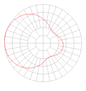 | ||||||||||||||||||
| Azimuth | Ratio | Azimuth | Ratio | Azimuth | Ratio | Azimuth | Ratio | ||||||||||||
| 0 | 0.628 | 10 | 0.547 | 20 | 0.474 | 30 | 0.415 | ||||||||||||
| 40 | 0.378 | 50 | 0.378 | 60 | 0.408 | 70 | 0.449 | ||||||||||||
| 80 | 0.487 | 90 | 0.515 | 100 | 0.527 | 110 | 0.522 | ||||||||||||
| 120 | 0.500 | 130 | 0.467 | 140 | 0.430 | 150 | 0.400 | ||||||||||||
| 160 | 0.398 | 170 | 0.440 | 180 | 0.510 | 190 | 0.590 | ||||||||||||
| 200 | 0.671 | 210 | 0.748 | 220 | 0.818 | 230 | 0.877 | ||||||||||||
| 240 | 0.924 | 250 | 0.958 | 260 | 0.980 | 270 | 0.994 | ||||||||||||
| 280 | 1.000 | 290 | 0.990 | 300 | 0.973 | 310 | 0.946 | ||||||||||||
| 320 | 0.907 | 330 | 0.857 | 340 | 0.792 | 350 | 0.713 | ||||||||||||
Structure Registration Number 1301089 Structure Type: GTOWER Registered To: WBOC, Inc. Structure Address: Wboc-tv Tower Site, 1616 Draper Lane,ralph's Road Sw, Laurel, DE County Name: Sussex County ASR Issued: 01/11/2017 Date Built: 08/31/2000 Site Elevation: 14 m (46 ft.) Structure Height: 271.3 m (890 ft.) Height Overall: 305.4 m (1002 ft.) Overall Height AMSL: 319.4 m (1048 ft.) FAA Determination: 12/21/2016 FAA Study #: 2016-AEA-10901-OE FAA Circular #: 70/7460-1L Paint & Light FAA Chapters: 4, 7, 12 Removed expiration date from determination. Scenario 1./jjs/case#635066 38-30-18.0 N 75-38-36.0 W (NAD 83) 38-30-17.6 N 75-38-37.3 W (Converted to NAD 27) |
1729 North Salisbury Boulevard Salisbury, MD 21801 Phone: 443-880-9090 Corporation | Title: President, Draper Media Date: 06/09/2021 Application Certifier WBOC, Inc. Wboc, Inc. 1729 North Salisbury Boulevard Salisbury, MD 21801 Applicant Josh Lynch Wboc, Inc. 1729 North Salisbury Boulevard Salisbury, MD 21801 Acting Chief Engineer Christina Burrow Cooley Llp 1299 Pennsylvania Avenue, Nw Suite 700 Washington, DC 20004 Legal Counsel Joseph M. Davis, P.E. Chesapeake Rf Consultants, Llc 207 Old Dominion Road Yorktown, VA 23692 Consulting Engineer | |||||||||||||||||