
FCCInfo.com
A Service of Cavell, Mertz & Associates, Inc.
(855) FCC-INFO
|
|
W26EU-D from 04/18/2018 W26EU-D from 10/28/1999 W26EU-D from 11/07/1996 W26EU-D from 09/01/1995 W26EU-D from 08/23/1989 |
|
|
||||||||||||||||
|
|
Status: License Application Accepted: 06/21/2021 License Expires: 04/03/2023 File Number: -0000150613 FCC Website Links: LMS Facility Details This Application Other W26EU-D Applications Including Superseded Applications Mailing Address Correspondence for W26EU-D Correspondence related to application -0000150613 Service Contour - Open Street Map or USGS Map (51 dBu) Service Contour - KML / Google Earth (51 dBu) Rabbit Ears Info Search for W26EU-D Site Location: 42-18-27.8 N 71-13-24.9 W (NAD 83) Site Location: 42-18-27.4 N 71-13-26.7 W (Converted to NAD 27) ERP: 12 kW Polarization: Circularly polarized R/C AGL: 304 m (997 ft.) R/C AMSL: 332.6 m (1091 ft.) Emission Mask: Full Service Site Elevation: 28.6 m. (94 ft.) Height Overall*: 381.9 m (1253 ft.) (* As Filed In This Application, may differ from ASR Data, Below.) Directional Antenna - Antenna Make/Model: Systems With Reliability Inc. SWDDP2-2-0/26-CP Antenna ID: 1008314 Polarization: Circularly polarized | ||||||||||||||||||
| Antenna Data for Antenna Id: 1008314 W26EU-D LD File: -0000150613 Systems With Reliability Inc. - SWDDP2-2-0/26-CP Service: LD Standard Pattern: N Pattern and Field Values Include a 90° Clockwise Rotation | 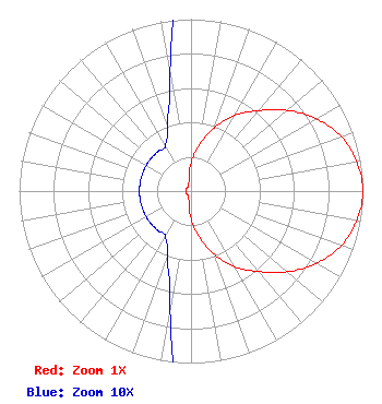 | ||||||||||||||||||
| Azimuth | Ratio | Azimuth | Ratio | Azimuth | Ratio | Azimuth | Ratio | ||||||||||||
| 0 | 0.160 | 10 | 0.270 | 20 | 0.390 | 30 | 0.510 | ||||||||||||
| 40 | 0.610 | 50 | 0.730 | 60 | 0.840 | 70 | 0.930 | ||||||||||||
| 80 | 0.980 | 90 | 1.000 | 100 | 0.980 | 110 | 0.930 | ||||||||||||
| 120 | 0.840 | 130 | 0.730 | 140 | 0.610 | 150 | 0.510 | ||||||||||||
| 160 | 0.390 | 170 | 0.270 | 180 | 0.160 | 190 | 0.070 | ||||||||||||
| 200 | 0.040 | 210 | 0.030 | 220 | 0.030 | 230 | 0.030 | ||||||||||||
| 240 | 0.030 | 250 | 0.030 | 260 | 0.030 | 270 | 0.030 | ||||||||||||
| 280 | 0.030 | 290 | 0.030 | 300 | 0.030 | 310 | 0.030 | ||||||||||||
| 320 | 0.030 | 330 | 0.030 | 340 | 0.040 | 350 | 0.070 | ||||||||||||
Structure Registration Number 1004623 Structure Type: GTOWER Registered To: American Towers LLC Structure Address: 1165 Chestnut St ( 001028 ) Newton, MA County Name: Middlesex County ASR Issued: 12/20/2018 Date Built: 10/28/2004 Site Elevation: 28.6 m (94 ft.) Structure Height: 358.7 m (1177 ft.) Height Overall: 381.9 m (1253 ft.) Overall Height AMSL: 410.5 m (1347 ft.) FAA Determination: 12/18/2018 FAA Study #: 2018-ANE-6211-OE FAA Circular #: 70/7460-1L Paint & Light FAA Chapters: 3, 4, 5, 12 42-18-27.8 N 71-13-24.9 W (NAD 83) 42-18-27.4 N 71-13-26.7 W (Converted to NAD 27) |
3901 Highway121 South Bedford, TX 76021 Phone: 817-571-1229 Applicant | Title: President Date: 06/21/2021 Application Certifier WORD OF GOD FELLOWSHIP, INC. Word Of God Fellowship, Inc. 3901 Highway121 South Bedford, TX 76021 Applicant Ari Meltzer Wiley Rein Llp 9808 Clydesdale St Potomac, MD 20854 Richard C Goetz R & L Media Systems 135 N Country Club Dr Hendersonville, TN 37075 Broadcast Consultant | |||||||||||||||||