
FCCInfo.com
A Service of Cavell, Mertz & Associates, Inc.
(855) FCC-INFO
|
|
W42CK from 06/18/1997 W42CK from 08/24/1995 W42CK from 01/27/1988 |
|
|
||||||||||||||||
|
|
Status: STA – Special Temporary Authority (Licensed And Silent) Application Accepted: 06/29/2021 STA Expires: 00/00/0000 File Number: -0000149513 FCC Website Links: LMS Facility Details This Application Other W42CK Applications Including Superseded Applications Mailing Address Correspondence for W42CK Correspondence related to application -0000149513 Service Contour - Open Street Map or USGS Map (74 dBu) Service Contour - KML / Google Earth (74 dBu) Rabbit Ears Info Search for W42CK Site Location: 39-36-38.0 N 77-46-54.0 W (NAD 83) Site Location: 39-36-37.7 N 77-46-55.0 W (Converted to NAD 27) ERP: 6.37 kW Polarization: Horizontally polarized R/C AGL: 45 m (148 ft.) R/C AMSL: 200.4 m (657 ft.) Site Elevation: 155.4 m. (510 ft.) Height Overall*: 82 m (269 ft.) (* As Filed In This Application, may differ from ASR Data, Below.) Directional Antenna - Antenna Make/Model: Antenna Concepts Inc. ACB4DR Antenna ID: 17689 Polarization: Horizontally polarized | ||||||||||||||||||
| Antenna Data for Antenna Id: 17689 W42CK TX File: -0000149513 Antenna Concepts Inc. - ACB4DR Service: TX Standard Pattern: Y Pattern and Field Values Include a 16° Clockwise Rotation | 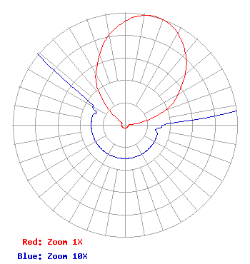 | ||||||||||||||||||
| Azimuth | Ratio | Azimuth | Ratio | Azimuth | Ratio | Azimuth | Ratio | ||||||||||||
| 6 | 0.970 | 16 | 1.000 | 26 | 0.970 | 36 | 0.880 | ||||||||||||
| 46 | 0.760 | 56 | 0.600 | 66 | 0.460 | 76 | 0.250 | ||||||||||||
| 86 | 0.060 | 96 | 0.030 | 106 | 0.030 | 116 | 0.030 | ||||||||||||
| 126 | 0.030 | 136 | 0.030 | 146 | 0.030 | 156 | 0.030 | ||||||||||||
| 166 | 0.030 | 176 | 0.030 | 186 | 0.030 | 196 | 0.030 | ||||||||||||
| 206 | 0.030 | 216 | 0.030 | 226 | 0.030 | 236 | 0.030 | ||||||||||||
| 246 | 0.030 | 256 | 0.030 | 266 | 0.030 | 276 | 0.030 | ||||||||||||
| 286 | 0.030 | 296 | 0.030 | 306 | 0.060 | 316 | 0.250 | ||||||||||||
| 326 | 0.460 | 336 | 0.600 | 346 | 0.760 | 356 | 0.880 | ||||||||||||
Structure Registration Number 1035657 Structure Type: TOWER Registered To: SM TOWERS, LLC Structure Address: 16907 Virginia Avenue Williamsport, MD County Name: Washington County ASR Issued: 04/03/2024 Date Built: 08/16/1999 Site Elevation: 155.4 m (510 ft.) Structure Height: 76.5 m (251 ft.) Height Overall: 82 m (269 ft.) Overall Height AMSL: 237.4 m (779 ft.) FAA Determination: 03/01/1999 FAA Study #: 99-AEA-0048-OE FAA Circular #: 70/7460-1J Paint & Light FAA Chapters: 4, 8, 13 Removed expiration date from determination. Scenario 1./jjs/case#635066 39-36-38.0 N 77-46-54.0 W (NAD 83) 39-36-37.7 N 77-46-55.0 W (Converted to NAD 27) |
Hurst, TX 76054 Phone: 214-770-7770 Corporation | Title: Ceo Date: 06/29/2021 Application Certifier EDGE SPECTRUM, INC. Edge Spectrum, Inc. Hurst, TX 76054 Applicant Caleb Weiss Ark Multicasting, Inc. Cedar Hill, TX 75106 President Randy Weiss Edge Spectrum, Inc. Hurst, TX 76054 CEO Susan Hansen B. W. St. Clair 2305 Vida Shaw Rd. New Iberia, LA 70563 Consultant | |||||||||||||||||