
FCCInfo.com
A Service of Cavell, Mertz & Associates, Inc.
(855) FCC-INFO
|
|
K40IJ-D from 08/22/2005 |
|
|
||||||||||||||||
|
|
Status: STA – Special Temporary Authority (Licensed And Silent) Application Accepted: 06/29/2021 STA Expires: 00/00/0000 File Number: -0000149721 FCC Website Links: LMS Facility Details This Application Other K40IJ-D Applications Including Superseded Applications Mailing Address Correspondence for K40IJ-D Correspondence related to application -0000149721 Service Contour - Open Street Map or USGS Map (51 dBu) Service Contour - KML / Google Earth (51 dBu) Rabbit Ears Info Search for K40IJ-D Site Location: 39-03-50.0 N 95-45-50.0 W (NAD 83) Site Location: 39-03-50.0 N 95-45-49.1 W (Converted to NAD 27) ERP: 5 kW Electrical Beam Tilt: 1 degree R/C AGL: 190.5 m (625 ft.) R/C AMSL: 519.5 m (1704 ft.) Emission Mask: Stringent Site Elevation: 329 m. (1079 ft.) Height Overall*: 285.7 m (937 ft.) (* As Filed In This Application, may differ from ASR Data, Below.) Directional Antenna - Antenna Make/Model: Propagation System Inc PSILP8BA Antenna ID: 20483 | ||||||||||||||||||
| Antenna Data for Antenna Id: 20483 K40IJ-D LD File: -0000149721 Propagation System Inc - PSILP8BA Service: LD Standard Pattern: Y Pattern and Field Values Include a 270° Clockwise Rotation | 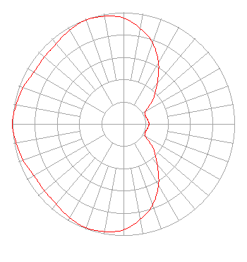 | ||||||||||||||||||
| Azimuth | Ratio | Azimuth | Ratio | Azimuth | Ratio | Azimuth | Ratio | ||||||||||||
| 0 | 0.950 | 10 | 0.870 | 20 | 0.770 | 30 | 0.630 | ||||||||||||
| 40 | 0.470 | 50 | 0.350 | 60 | 0.230 | 70 | 0.210 | ||||||||||||
| 80 | 0.220 | 90 | 0.230 | 100 | 0.220 | 110 | 0.210 | ||||||||||||
| 120 | 0.230 | 130 | 0.350 | 140 | 0.470 | 150 | 0.630 | ||||||||||||
| 160 | 0.770 | 170 | 0.870 | 180 | 0.950 | 190 | 0.980 | ||||||||||||
| 200 | 0.990 | 210 | 0.970 | 220 | 0.940 | 230 | 0.930 | ||||||||||||
| 240 | 0.930 | 250 | 0.960 | 260 | 0.980 | 270 | 1.000 | ||||||||||||
| 280 | 0.980 | 290 | 0.960 | 300 | 0.930 | 310 | 0.930 | ||||||||||||
| 320 | 0.940 | 330 | 0.970 | 340 | 0.990 | 350 | 0.980 | ||||||||||||
Structure Registration Number 1032651 Structure Type: Registered To: WASHBURN UNIVERSITY OF TOPEKA Structure Address: 301 Nw Wanamaker Road Topeka, KS County Name: Shawnee County ASR Issued: 01/02/2018 Date Built: 01/16/2004 Site Elevation: 329 m (1079 ft.) Structure Height: 265 m (869 ft.) Height Overall: 285.7 m (937 ft.) Overall Height AMSL: 614.7 m (2017 ft.) FAA Determination: 06/30/2000 FAA Study #: 00-ACE-0120-OE FAA Circular #: 70/7460-1K Paint & Light FAA Chapters: 3, 4, 5, 12 Removed final date from determination. Scenario 3./jjs/case#635066 39-03-50.0 N 95-45-50.0 W (NAD 83) 39-03-50.0 N 95-45-49.1 W (Converted to NAD 27) |
Hurst, TX 76054 Phone: 214-770-7770 Corporation | Title: Ceo Date: 06/29/2021 Application Certifier EDGE SPECTRUM, INC. Edge Spectrum, Inc. Hurst, TX 76054 Applicant Randy Weiss Edge Spectrum, Inc. Hurst, TX 76054 CEO Caleb Weiss Ark Multicasting, Inc. Cedar Hill, TX 75106 President Susan Hansen B. W. St. Clair 2305 Vida Shaw Rd. New Iberia, LA 70563 Consultant | |||||||||||||||||