
FCCInfo.com
A Service of Cavell, Mertz & Associates, Inc.
(855) FCC-INFO
|
|
K48KJ-D from 04/09/2007 K48KJ-D from 10/23/2006 K48KJ-D from 03/15/2004 |
|
|
||||||||||||||||
|
|
Status: STA – Special Temporary Authority (Licensed And Silent) Application Accepted: 06/29/2021 STA Expires: 00/00/0000 File Number: -0000149726 FCC Website Links: LMS Facility Details This Application Other K48KJ-D Applications Including Superseded Applications Mailing Address Correspondence for K48KJ-D Correspondence related to application -0000149726 Service Contour - Open Street Map or USGS Map (51 dBu) Service Contour - KML / Google Earth (51 dBu) Rabbit Ears Info Search for K48KJ-D Site Location: 44-02-43.9 N 93-23-02.7 W (NAD 83) Site Location: 44-02-44.0 N 93-23-01.9 W (Converted to NAD 27) ERP: 4.92 kW R/C AGL: 180 m (591 ft.) R/C AMSL: 527.4 m (1730 ft.) Emission Mask: Stringent Site Elevation: 347.4 m. (1140 ft.) Height Overall*: 210.3 m (690 ft.) (* As Filed In This Application, may differ from ASR Data, Below.) Directional Antenna - Antenna Make/Model: Jampro JA/LS-AL-8 Antenna ID: 19378 | ||||||||||||||||||
| Antenna Data for Antenna Id: 19378 K48KJ-D LD File: -0000149726 Jampro - JA/LS-AL-8 Service: LD Standard Pattern: Y | 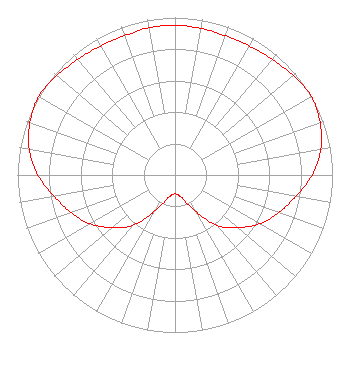 | ||||||||||||||||||
| Azimuth | Ratio | Azimuth | Ratio | Azimuth | Ratio | Azimuth | Ratio | ||||||||||||
| 0 | 0.950 | 10 | 0.945 | 20 | 0.940 | 30 | 0.945 | ||||||||||||
| 40 | 0.960 | 50 | 0.980 | 60 | 1.000 | 70 | 0.980 | ||||||||||||
| 80 | 0.940 | 90 | 0.870 | 100 | 0.780 | 110 | 0.700 | ||||||||||||
| 120 | 0.620 | 130 | 0.520 | 140 | 0.420 | 150 | 0.270 | ||||||||||||
| 160 | 0.170 | 170 | 0.130 | 180 | 0.120 | 190 | 0.130 | ||||||||||||
| 200 | 0.170 | 210 | 0.270 | 220 | 0.420 | 230 | 0.520 | ||||||||||||
| 240 | 0.620 | 250 | 0.700 | 260 | 0.780 | 270 | 0.870 | ||||||||||||
| 280 | 0.940 | 290 | 0.980 | 300 | 1.000 | 310 | 0.980 | ||||||||||||
| 320 | 0.960 | 330 | 0.945 | 340 | 0.940 | 350 | 0.950 | ||||||||||||
Structure Registration Number 1030901 Structure Type: TOWER Registered To: BLOOMING PRAIRIE FARM RADIO INC = KOWZ-FM + KRUE Structure Address: 2 Mi S Of Meriden Nr Waseca, MN County Name: Steele County ASR Issued: 05/27/2011 Date Built: 01/01/1994 Site Elevation: 347.4 m (1140 ft.) Structure Height: 209.4 m (687 ft.) Height Overall: 210.3 m (690 ft.) Overall Height AMSL: 557.7 m (1830 ft.) FAA Determination: 05/26/2011 FAA Study #: 2011-AGL-2683-OE FAA Circular #: 70/7460-1H Paint & Light FAA Chapters: 3, 4, 5, 13 PRIOR STUDY 1994-AGL-2032-OE 44-02-43.9 N 93-23-02.7 W (NAD 83) 44-02-44.0 N 93-23-01.9 W (Converted to NAD 27) |
Hurst, TX 76054 Phone: 214-770-7770 Corporation | Title: Ceo Date: 06/29/2021 Application Certifier EDGE SPECTRUM, INC. Edge Spectrum, Inc. Hurst, TX 76054 Applicant Randy Weiss Edge Spectrum, Inc. Hurst, TX 76054 CEO Caleb Weiss Ark Multicasting, Inc. Cedar Hill, TX 75106 President Susan Hansen B. W. St. Clair 2305 Vida Shaw Rd. New Iberia, LA 70563 Consultant | |||||||||||||||||