
FCCInfo.com
A Service of Cavell, Mertz & Associates, Inc.
(855) FCC-INFO
|
|
KTCJ-LD from 07/16/2007 KTCJ-LD from 08/03/2004 |
|
|
||||||||||||||||
|
|
Status: STA – Special Temporary Authority (Licensed And Silent) Application Accepted: 06/29/2021 STA Expires: 00/00/0000 File Number: -0000149733 FCC Website Links: LMS Facility Details This Application Other KTCJ-LD Applications Including Superseded Applications Mailing Address Correspondence for KTCJ-LD Correspondence related to application -0000149733 Service Contour - Open Street Map or USGS Map (51 dBu) Service Contour - KML / Google Earth (51 dBu) Rabbit Ears Info Search for KTCJ-LD Site Location: 45-04-07.1 N 93-10-35.1 W (NAD 83) Site Location: 45-04-07.2 N 93-10-34.3 W (Converted to NAD 27) ERP: 15 kW R/C AGL: 140 m (459 ft.) R/C AMSL: 421 m (1381 ft.) Emission Mask: Stringent Site Elevation: 281 m. (922 ft.) Height Overall*: 190.5 m (625 ft.) (* As Filed In This Application, may differ from ASR Data, Below.) Directional Antenna - Antenna Make/Model: MICRO COMMUNICATIONS INC 955516 CUSTOM Antenna ID: 93999 | ||||||||||||||||||
| Antenna Data for Antenna Id: 93999 KTCJ-LD LD File: -0000149733 MICRO COMMUNICATIONS INC - 955516 CUSTOM Service: LD Standard Pattern: Y Pattern and Field Values Include a 215° Clockwise Rotation | 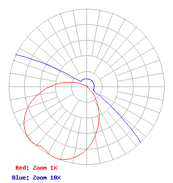 | ||||||||||||||||||
| Azimuth | Ratio | Azimuth | Ratio | Azimuth | Ratio | Azimuth | Ratio | ||||||||||||
| 5 | 0.010 | 15 | 0.010 | 25 | 0.010 | 35 | 0.010 | ||||||||||||
| 45 | 0.010 | 55 | 0.010 | 65 | 0.010 | 75 | 0.010 | ||||||||||||
| 85 | 0.010 | 95 | 0.010 | 105 | 0.010 | 115 | 0.010 | ||||||||||||
| 125 | 0.021 | 135 | 0.094 | 145 | 0.218 | 155 | 0.378 | ||||||||||||
| 165 | 0.556 | 175 | 0.729 | 185 | 0.872 | 195 | 0.967 | ||||||||||||
| 205 | 1.000 | 215 | 0.967 | 225 | 1.000 | 235 | 0.967 | ||||||||||||
| 245 | 0.872 | 255 | 0.729 | 265 | 0.556 | 275 | 0.378 | ||||||||||||
| 285 | 0.218 | 295 | 0.094 | 305 | 0.021 | 315 | 0.010 | ||||||||||||
| 325 | 0.010 | 335 | 0.010 | 345 | 0.010 | 355 | 0.010 | ||||||||||||
Structure Registration Number 1060523 Structure Type: TOWER Registered To: ARDEN TOWERS INC Structure Address: 1777 14th St Arden Hills, MN County Name: Ramsey County ASR Issued: 04/19/2011 Date Built: 04/20/2011 Site Elevation: 281 m (922 ft.) Structure Height: 190.5 m (625 ft.) Height Overall: 190.5 m (625 ft.) Overall Height AMSL: 471.5 m (1547 ft.) FAA Determination: 03/10/2011 FAA Study #: 2011-AGL-1809-OE Paint & Light FAA Chapters: A2, H, 1, 3, 4, 13, 21, 23 PRIOR STUDY 1980-AGL-1037-OE 45-04-07.1 N 93-10-35.1 W (NAD 83) 45-04-07.2 N 93-10-34.3 W (Converted to NAD 27) |
Hurst, TX 76054 Phone: 214-770-7770 Corporation | Title: Ceo Date: 06/29/2021 Application Certifier EDGE SPECTRUM, INC. Edge Spectrum, Inc. Hurst, TX 76054 Applicant Randy Weiss Edge Spectrum, Inc. Hurst, TX 76054 CEO Caleb Weiss Ark Multicasting, Inc. Cedar Hill, TX 75106 President Susan Hansen B. W. St. Clair 2305 Vida Shaw Rd. New Iberia, LA 70563 Consultant | |||||||||||||||||