
FCCInfo.com
A Service of Cavell, Mertz & Associates, Inc.
(855) FCC-INFO
|
|
WAOE from 09/08/1995 |
Post-repack Channel 33 Virtual Channel 59 |  |
|
|||||||||||||||||||||
|
|
Repacking Information: Pre-Repack Channel: 39 Post-Repack Channel: 33 Post-Repack ERP: 23.1 kW Phase: 7 Completion Deadline: 1/17/2020 Find nearby TV Facilities Status: License Application Accepted: 07/02/2021 License Expires: 12/01/2021 File Number: -0000151562 FCC Website Links: LMS Facility Details This Application Other WTVK Applications Including Superseded Applications Mailing Address Correspondence for WTVK Correspondence related to application -0000151562 Service Contour - Open Street Map or USGS Map (36 dBu) Service Contour - KML / Google Earth (36 dBu) Public Inspection Files Rabbit Ears Info Search for WTVK Site Location: 41-16-54.6 N 88-56-11.1 W (NAD 83) Site Location: 41-16-54.5 N 88-56-10.8 W (Converted to NAD 27) ERP: 24 kW Polarization: Elliptically polarized HAAT: 212 m (696 ft.) Electrical Beam Tilt: 0.50 degrees R/C AGL: 404 m (1325 ft.) R/C AMSL: 596.6 m (1957 ft.) Site Elevation: 192.6 m. (632 ft.) Height Overall*: 418.6 m (1373 ft.) (* As Filed In This Application, may differ from ASR Data, Below.) Directional Antenna - Antenna Make/Model: ALIVE TELECOM ATC-BCE04H-VP1-10 Antenna ID: 1008363 Polarization: Elliptically polarized
| ||||||||||||||||||||||||
| Antenna Data for Antenna Id: 1008363 WTVK DT File: -0000151562 ALIVE TELECOM - ATC-BCE04H-VP1-10 Service: DT Standard Pattern: N Pattern and Field Values Include a 220° Clockwise Rotation | 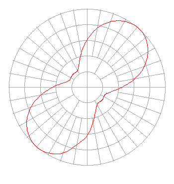 | ||||||||||||||||||||||||
| Azimuth | Ratio | Azimuth | Ratio | Azimuth | Ratio | Azimuth | Ratio | ||||||||||||||||||
| 0 | 0.600 | 10 | 0.764 | 20 | 0.889 | 30 | 0.967 | ||||||||||||||||||
| 40 | 1.000 | 50 | 0.974 | 60 | 0.897 | 70 | 0.781 | ||||||||||||||||||
| 80 | 0.622 | 90 | 0.451 | 100 | 0.324 | 110 | 0.258 | ||||||||||||||||||
| 120 | 0.248 | 130 | 0.256 | 140 | 0.248 | 150 | 0.258 | ||||||||||||||||||
| 160 | 0.324 | 170 | 0.451 | 180 | 0.622 | 190 | 0.748 | ||||||||||||||||||
| 200 | 0.897 | 210 | 0.974 | 220 | 1.000 | 230 | 0.968 | ||||||||||||||||||
| 240 | 0.889 | 250 | 0.764 | 260 | 0.600 | 270 | 0.432 | ||||||||||||||||||
| 280 | 0.302 | 290 | 0.242 | 300 | 0.237 | 310 | 0.242 | ||||||||||||||||||
| 320 | 0.237 | 330 | 0.242 | 340 | 0.302 | 350 | 0.432 | ||||||||||||||||||
Structure Registration Number 1028357 Structure Type: GTOWER Registered To: American Towers LLC Structure Address: 6.1 Km Sw Int Chicago Rd & Sr 71 Oglesby, IL County Name: LaSalle County ASR Issued: 01/05/2021 Date Built: 11/01/2014 Site Elevation: 192.6 m (632 ft.) Structure Height: 418.6 m (1373 ft.) Height Overall: 418.6 m (1373 ft.) Overall Height AMSL: 611.2 m (2005 ft.) FAA Determination: 06/11/2014 FAA Study #: 2014-AGL-3750-OE FAA Circular #: 70/7460-1F Paint & Light FAA Chapters: 4, 6, 9 PRIOR STUDY 1985-AGL-475-OE 41-16-54.6 N 88-56-11.1 W (NAD 83) 41-16-54.5 N 88-56-10.8 W (Converted to NAD 27) |
150 S Arroyo Pkwy #103 Pasadena, CA 91105 Phone: 323-965-5400 Limited Liability Company | Title: Manager Date: 07/02/2021 Application Certifier Four Seasons Peoria, Llc 5670 Wilshire Boulevard, Suite 1620 Los Angeles, CA 90036 Applicant LAWRENCE ROGOW Four Seasons Peoria, Llc 5670 Wilshire Blvd., Suite 1620 Los Angeles, CA 90036 MANAGER JOAN STEWART Wiley Rein Llp 1776 K Street Nw Washington, DC 20006 | |||||||||||||||||||||||
| |||||||||||||||||||||||||