
FCCInfo.com
A Service of Cavell, Mertz & Associates, Inc.
(855) FCC-INFO
|
|
K13XW-D from 01/09/2003 |
|
|
||||||||||||||||
|
|
Status: License Application Accepted: 07/08/2021 License Expires: 04/01/2022 File Number: -0000152087 FCC Website Links: LMS Facility Details This Application Other K13XW-D Applications Including Superseded Applications Mailing Address Correspondence for K13XW-D Correspondence related to application -0000152087 Service Contour - Open Street Map or USGS Map (48 dBu) Service Contour - KML / Google Earth (48 dBu) Rabbit Ears Info Search for K13XW-D Site Location: 40-16-52.0 N 103-05-57.0 W (NAD 83) Site Location: 40-16-52.1 N 103-05-55.2 W (Converted to NAD 27) ERP: 0.026 kW Polarization: Horizontally polarized R/C AGL: 83.8 m (275 ft.) R/C AMSL: 1452 m (4764 ft.) Emission Mask: Simple Site Elevation: 1368.2 m. (4489 ft.) Height Overall*: 95.7 m (314 ft.) (* As Filed In This Application, may differ from ASR Data, Below.) Directional Antenna - Antenna Make/Model: Scala CL-713 (6) Antenna ID: 38826 Polarization: Horizontally polarized
| ||||||||||||||||||
| Antenna Data for Antenna Id: 38826 K13XW-D LD File: -0000152087 Scala - CL-713 (6) Service: LD Standard Pattern: Y Pattern and Field Values Include a 285° Clockwise Rotation | 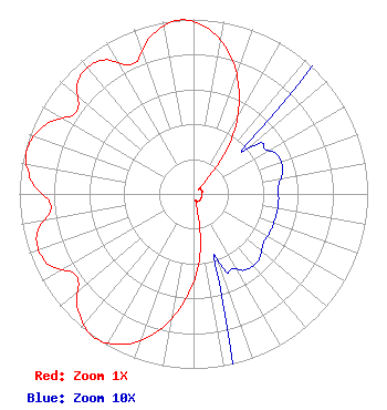 | ||||||||||||||||||
| Azimuth | Ratio | Azimuth | Ratio | Azimuth | Ratio | Azimuth | Ratio | ||||||||||||
| 5 | 0.951 | 15 | 0.820 | 25 | 0.619 | 35 | 0.381 | ||||||||||||
| 45 | 0.068 | 55 | 0.049 | 65 | 0.053 | 75 | 0.053 | ||||||||||||
| 85 | 0.049 | 95 | 0.049 | 105 | 0.049 | 115 | 0.049 | ||||||||||||
| 125 | 0.049 | 135 | 0.053 | 145 | 0.053 | 155 | 0.049 | ||||||||||||
| 165 | 0.068 | 175 | 0.381 | 185 | 0.619 | 195 | 0.820 | ||||||||||||
| 205 | 0.951 | 215 | 1.000 | 225 | 0.937 | 235 | 0.820 | ||||||||||||
| 245 | 0.933 | 255 | 0.933 | 265 | 0.820 | 275 | 0.937 | ||||||||||||
| 285 | 0.990 | 295 | 0.937 | 305 | 0.820 | 315 | 0.933 | ||||||||||||
| 325 | 0.933 | 335 | 0.820 | 345 | 0.937 | 355 | 1.000 | ||||||||||||
Structure Registration Number 1028051 Structure Type: TOWER Registered To: BOARD OF WASHINGTON COUNTY COMMISSIONERS Structure Address: Washington Cr 49 & Jj Akron, CO County Name: Washington County ASR Issued: 04/08/2014 Date Built: 10/21/2005 Site Elevation: 1368.2 m (4489 ft.) Structure Height: 91.4 m (300 ft.) Height Overall: 95.7 m (314 ft.) Overall Height AMSL: 1463.9 m (4803 ft.) FAA Determination: 09/06/2005 FAA Study #: 2005-ANM-1787-OE FAA Circular #: 70/7460-1K Paint & Light FAA Chapters: 4, 8, 12 Removed expiration date from determination. Scenario 1./jjs/case#635066 40-16-52.0 N 103-05-57.0 W (NAD 83) 40-16-52.1 N 103-05-55.2 W (Converted to NAD 27) |
221 S Interocean Ave Holyoke, CO 80734 Phone: 970-854-3778 Government Entity | Title: Chief Operator Date: 07/08/2021 Application Certifier REGION 1 TRANSLATOR ASSOCIATION Region 1 Translator Association 221 S Interocean Ave Holyoke, CO 80734 Applicant Ed Lake Rf Systems Llc 323 W 4th Ave Yuma, CO 80759 Laura Schroetlin Region 1 Translator Association 221 S Interocean Ave Holyoke, CO 80734 | |||||||||||||||||