
FCCInfo.com
A Service of Cavell, Mertz & Associates, Inc.
(855) FCC-INFO
|
|
|
|
|
||||||||||||||||
|
|
Status: License Application Accepted: 07/08/2021 License Expires: 08/01/2022 File Number: -0000151977 FCC Website Links: LMS Facility Details This Application Other K33QH-D Applications Including Superseded Applications Mailing Address Correspondence for K33QH-D Correspondence related to application -0000151977 Service Contour - Open Street Map or USGS Map (51 dBu) Service Contour - KML / Google Earth (51 dBu) Rabbit Ears Info Search for K33QH-D Site Location: 29-12-13.2 N 99-49-29.6 W (NAD 83) Site Location: 29-12-12.3 N 99-49-28.4 W (Converted to NAD 27) ERP: 0.5 kW Polarization: Horizontally polarized R/C AGL: 100 m (328 ft.) R/C AMSL: 386.2 m (1267 ft.) Emission Mask: Full Service Site Elevation: 286.2 m. (939 ft.) Height Overall*: 138.4 m (454 ft.) (* As Filed In This Application, may differ from ASR Data, Below.) Directional Antenna - Antenna Make/Model: SBP UPC Antenna ID: 107572 Polarization: Horizontally polarized | ||||||||||||||||||
| Antenna Data for Antenna Id: 107572 K33QH-D LD File: -0000151977 SBP - UPC Service: LD Standard Pattern: Y Pattern and Field Values Include a 90° Clockwise Rotation | 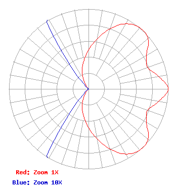 | ||||||||||||||||||
| Azimuth | Ratio | Azimuth | Ratio | Azimuth | Ratio | Azimuth | Ratio | ||||||||||||
| 0 | 0.485 | 10 | 0.636 | 20 | 0.803 | 30 | 0.939 | ||||||||||||
| 40 | 1.000 | 50 | 0.977 | 60 | 0.839 | 70 | 0.789 | ||||||||||||
| 80 | 0.895 | 90 | 0.999 | 100 | 0.895 | 110 | 0.789 | ||||||||||||
| 120 | 0.839 | 130 | 0.977 | 140 | 1.000 | 150 | 0.939 | ||||||||||||
| 160 | 0.803 | 170 | 0.636 | 180 | 0.485 | 190 | 0.348 | ||||||||||||
| 200 | 0.237 | 210 | 0.120 | 220 | 0.024 | 230 | 0.001 | ||||||||||||
| 240 | 0.001 | 250 | 0.001 | 260 | 0.001 | 270 | 0.001 | ||||||||||||
| 280 | 0.001 | 290 | 0.001 | 300 | 0.001 | 310 | 0.001 | ||||||||||||
| 320 | 0.024 | 330 | 0.120 | 340 | 0.237 | 350 | 0.348 | ||||||||||||
Structure Registration Number 1049654 Structure Type: TOWER Registered To: Global Tower, LLC. through American Towers, LLC Structure Address: 2 Mi Sw Of Uvalde Uvalde, TX County Name: Uvalde County ASR Issued: 08/29/2014 Date Built: 02/28/1994 Site Elevation: 286.2 m (939 ft.) Structure Height: 134.7 m (442 ft.) Height Overall: 138.4 m (454 ft.) Overall Height AMSL: 424.6 m (1393 ft.) FAA Determination: 01/21/2007 FAA Study #: 2006-ASW-7609-OE FAA Circular #: 70/7460-1H Paint & Light FAA Chapters: 4, 8, 13 OM&L to remain the same as prior study = A MED-DUAL SYSTEM 29-12-13.2 N 99-49-29.6 W (NAD 83) 29-12-12.3 N 99-49-28.4 W (Converted to NAD 27) |
8330 Lyndon B Johnson Fwy Suite B400 Dallas, TX 75243 Phone: 214-434-5600 Corporation | Title: President Date: 07/08/2021 Application Certifier HISPANIC FAMILY CHRISTIAN NETWORK, INC. Hispanic Family Christian Network, Inc. 8330 Lyndon B Johnson Fwy Suite B310 Dallas, TX 75243 Applicant Dan J Alpert The Law Office Of Dan J. Alpert 2120 21st Rd. N Arlington, VA 22201 Legal Counsel | |||||||||||||||||