
FCCInfo.com
A Service of Cavell, Mertz & Associates, Inc.
(855) FCC-INFO
|
|
W26EP-D from 08/26/2016 |
|
|
||||||||||||||||
|
|
Status: License Application Accepted: 07/13/2021 License Expires: 06/01/2023 File Number: -0000152599 FCC Website Links: LMS Facility Details This Application Other WNGF-LD Applications Including Superseded Applications Mailing Address Correspondence for WNGF-LD Correspondence related to application -0000152599 Service Contour - Open Street Map or USGS Map (51 dBu) Service Contour - KML / Google Earth (51 dBu) Rabbit Ears Info Search for WNGF-LD Site Location: 44-38-54.8 N 75-01-06.4 W (NAD 83) Site Location: 44-38-54.6 N 75-01-07.7 W (Converted to NAD 27) ERP: 0.075 kW Polarization: Horizontally polarized R/C AGL: 70 m (230 ft.) R/C AMSL: 212.3 m (697 ft.) Emission Mask: Stringent Site Elevation: 142.3 m. (467 ft.) Height Overall*: 123.4 m (405 ft.) (* As Filed In This Application, may differ from ASR Data, Below.) Directional Antenna - Antenna Make/Model: Electronics Research Inc. ALP-ER Antenna ID: 1008439 Polarization: Horizontally polarized | ||||||||||||||||||
| Antenna Data for Antenna Id: 1008439 WNGF-LD LD File: -0000152599 Electronics Research Inc. - ALP-ER Service: LD Standard Pattern: N Pattern and Field Values Include a 145° Clockwise Rotation | 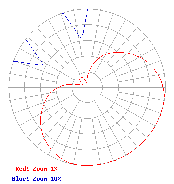 | ||||||||||||||||||
| Azimuth | Ratio | Azimuth | Ratio | Azimuth | Ratio | Azimuth | Ratio | ||||||||||||
| 5 | 0.145 | 15 | 0.292 | 25 | 0.427 | 35 | 0.529 | ||||||||||||
| 45 | 0.623 | 55 | 0.724 | 65 | 0.814 | 75 | 0.886 | ||||||||||||
| 85 | 0.945 | 95 | 0.987 | 105 | 1.000 | 115 | 1.000 | ||||||||||||
| 125 | 1.000 | 135 | 1.000 | 145 | 1.000 | 155 | 1.000 | ||||||||||||
| 165 | 1.000 | 175 | 1.000 | 185 | 1.000 | 195 | 0.987 | ||||||||||||
| 205 | 0.945 | 215 | 0.886 | 225 | 0.814 | 235 | 0.724 | ||||||||||||
| 245 | 0.623 | 255 | 0.529 | 265 | 0.427 | 275 | 0.292 | ||||||||||||
| 285 | 0.145 | 295 | 0.067 | 305 | 0.085 | 315 | 0.136 | ||||||||||||
| 325 | 0.146 | 335 | 0.136 | 345 | 0.085 | 355 | 0.067 | ||||||||||||
Structure Registration Number 1002336 Structure Type: GTOWER Registered To: Spectrum Northeast, LLC Structure Address: 783 Bagdad Rd Potsdam, NY County Name: St. Lawrence County ASR Issued: 09/03/2019 Date Built: 01/01/1990 Site Elevation: 142.3 m (467 ft.) Structure Height: 121.9 m (400 ft.) Height Overall: 123.4 m (405 ft.) Overall Height AMSL: 265.7 m (872 ft.) FAA Determination: 01/17/2018 FAA Study #: 2016-AEA-7661-OE FAA Circular #: 70/7460-1G Paint & Light FAA Chapters: 3, 4, 5, 9 OM&L to remain the same as prior study = PAINT/RED LIGHTS 44-38-54.8 N 75-01-06.4 W (NAD 83) 44-38-54.6 N 75-01-07.7 W (Converted to NAD 27) |
65 King Rd Buskirk, NY 12028 Phone: 518-686-0975 Not-for-Profit | Title: Manager Date: 07/13/2021 Application Certifier NORTHEAST GOSPEL BROADCASTING INC. Northeast Gospel Broadcasting Inc. 65 King Rd Buskirk, NY 12028 Applicant Richard C Goetz R & L Media Systems 135 N Country Clun Dr Hendersonville, TN 37075 Broadcast Consultant JOHN BURRELL Sterling Communications Sterling Communications, Inc. 219 Dodd Road Ringgold, GA 30736 TECHNICAL CONSULTANT Lee G Petro Drinker Biddle & Reath, Llp 1500 K Street, N.w. Suite 1100 Washington, DC 20005 FCC Contact | |||||||||||||||||