
FCCInfo.com
A Service of Cavell, Mertz & Associates, Inc.
(855) FCC-INFO
|
|
WPNY-LD from 10/07/1996 WPNY-LD from 12/22/1995 WPNY-LD from 01/11/1988 |
|
|
||||||||||||||||
|
|
Status: License Application Accepted: 07/14/2021 License Expires: 06/01/2023 File Number: -0000152875 FCC Website Links: LMS Facility Details This Application Other WPNY-LD Applications Including Superseded Applications Mailing Address Correspondence for WPNY-LD Correspondence related to application -0000152875 Service Contour - Open Street Map or USGS Map (48 dBu) Service Contour - KML / Google Earth (48 dBu) Rabbit Ears Info Search for WPNY-LD Site Location: 43-08-41.1 N 75-10-32.2 W (NAD 83) Site Location: 43-08-40.8 N 75-10-33.6 W (Converted to NAD 27) ERP: 0.16 kW Polarization: Horizontally polarized R/C AGL: 59.4 m (195 ft.) R/C AMSL: 431.2 m (1415 ft.) Emission Mask: Stringent Site Elevation: 371.8 m. (1220 ft.) Height Overall*: 130.7 m (429 ft.) (* As Filed In This Application, may differ from ASR Data, Below.) Directional Antenna - Antenna Make/Model: Scala DRV-1/3 HC Antenna ID: 1008448 Polarization: Horizontally polarized | ||||||||||||||||||
| Antenna Data for Antenna Id: 1008448 WPNY-LD LD File: -0000152875 Scala - DRV-1/3 HC Service: LD Standard Pattern: N | 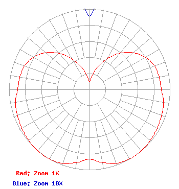 | ||||||||||||||||||
| Azimuth | Ratio | Azimuth | Ratio | Azimuth | Ratio | Azimuth | Ratio | ||||||||||||
| 0 | 0.091 | 10 | 0.166 | 20 | 0.295 | 30 | 0.438 | ||||||||||||
| 40 | 0.584 | 50 | 0.709 | 60 | 0.800 | 70 | 0.856 | ||||||||||||
| 80 | 0.878 | 90 | 0.892 | 100 | 0.933 | 110 | 0.952 | ||||||||||||
| 120 | 0.969 | 130 | 0.986 | 140 | 0.997 | 145 | 1.000 | ||||||||||||
| 150 | 0.996 | 160 | 0.978 | 170 | 0.923 | 180 | 0.869 | ||||||||||||
| 190 | 0.923 | 200 | 0.978 | 210 | 0.996 | 215 | 1.000 | ||||||||||||
| 220 | 0.997 | 230 | 0.986 | 240 | 0.969 | 250 | 0.952 | ||||||||||||
| 260 | 0.933 | 270 | 0.892 | 280 | 0.878 | 290 | 0.856 | ||||||||||||
| 300 | 0.800 | 310 | 0.709 | 320 | 0.584 | 330 | 0.438 | ||||||||||||
| 340 | 0.295 | 350 | 0.166 | ||||||||||||||||
Structure Registration Number 1003764 Structure Type: GTOWER Registered To: Mission Broadcasting, Inc. Structure Address: Atop Smith Hill Rd Approx 2 Mi Ne Utica, NY County Name: Oneida County ASR Issued: 03/09/2015 Date Built: 03/11/2015 Site Elevation: 371.8 m (1220 ft.) Structure Height: 113.6 m (373 ft.) Height Overall: 130.7 m (429 ft.) Overall Height AMSL: 502.5 m (1649 ft.) FAA Determination: 01/30/2015 FAA Study #: 2015-AEA-291-OE Paint & Light FAA Chapters: 1, 3, 12, 21 Continue As Is OM&L = PAINT/RED LIGHTS 43-08-41.1 N 75-10-32.2 W (NAD 83) 43-08-40.8 N 75-10-33.6 W (Converted to NAD 27) |
545 E. John Carpenter Freeway Suite 700 Irving, TX 75062 Phone: 972-373-8800 Corporation | Title: General Counsel Date: 07/14/2021 Application Certifier Nexstar Media Inc. 545 E. John Carpenter Freeway Suite 700 Irving, TX 75062 Applicant Greg Best Greg Best Consulting, Inc 16100 Outlook Ave Stilwell, KS 66085 Consulting Engineer Elizabeth Ryder Nexstar Inc. 545 E John Carpenter Fwy Suite 700 Irving, TX 75062 General Counsel | |||||||||||||||||